Kionga Triangle
The Kionga Triangle (German: Kionga-Dreieck, Portuguese: Triângulo de Quionga) was a small region of German East Africa situated on the border with Portuguese Mozambique. The area itself was situated on the Portuguese side of the Ruvuma River which served as the border between the two colonies. Its principal settlement was Kionga (now Quionga) which had a population of 4,000 in 1910. It became a German possession in 1894 but came under Portuguese control in April 1916 during World War I.[1] The post-war Treaty of Versailles reaffirmed that the river was the border between Tanganyika, now under British control, and Portuguese Mozambique. The triangle was the only territory that the treaty awarded to Portugal.
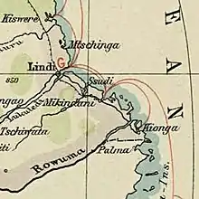
Today, the former Kionga Triangle forms part of Cabo Delgado Province in Mozambique.
References
- Hew Strachan (2004). The First World War in Africa. Oxford University Press. p. 161. ISBN 9780199257287. Retrieved 21 September 2017.
Further reading
- Thomas, H. B., "The Kionga Triangle", Tanganyika Notes and Records Volume 31 1951, pages 47–50.
| Colonies |
| |||||
|---|---|---|---|---|---|---|
| Concessions |
| |||||
| Unrecognised |
| |||||