Kot ob Kolpi
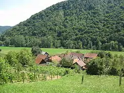
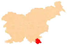
Kot ob Kolpi (pronounced [ˈkoːt ɔp ˈkoːlpi]; German: Winkel[2]) is a small settlement on the left bank of the Kolpa River south of Stari Trg ob Kolpi in the Municipality of Črnomelj in the White Carniola area of southeastern Slovenia. The area is part of the traditional region of Lower Carniola and is now included in the Southeast Slovenia Statistical Region.[3]
Kot ob Kolpi | |
|---|---|
 | |
 Kot ob Kolpi Location in Slovenia | |
| Coordinates: 45°29′22.88″N 15°4′10.47″E | |
| Country | |
| Traditional region | White Carniola |
| Statistical region | Southeast Slovenia |
| Municipality | Črnomelj |
| Area | |
| • Total | 0.19 km2 (0.07 sq mi) |
| Elevation | 196.6 m (645.0 ft) |
| [1] | |
Name
The name of the settlement was changed from Kot to Kot ob Kolpi in 1953.[4]
References
- Statistical Office of the Republic of Slovenia
- Leksikon občin kraljestev in dežel zastopanih v državnem zboru, vol. 6: Kranjsko. 1906. Vienna: C. Kr. Dvorna in Državna Tiskarna, p. 8.
- Črnomelj municipal site
- Spremembe naselij 1948–95. 1996. Database. Ljubljana: Geografski inštitut ZRC SAZU, DZS.
External links
This article is issued from Wikipedia. The text is licensed under Creative Commons - Attribution - Sharealike. Additional terms may apply for the media files.
