Kotoura, Tottori
Kotoura (琴浦町, Kotoura-chō) is a town located in Tōhaku District, Tottori Prefecture, Japan.
Kotoura
琴浦町 | |||||||||||||
|---|---|---|---|---|---|---|---|---|---|---|---|---|---|
Town | |||||||||||||
 Flag  Emblem | |||||||||||||
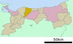 Location of Kotoura in Tottori Prefecture | |||||||||||||
 Kotoura Location in Japan | |||||||||||||
| Coordinates: 35°30′N 133°42′E | |||||||||||||
| Country | Japan | ||||||||||||
| Region | Chūgoku San'in | ||||||||||||
| Prefecture | Tottori Prefecture | ||||||||||||
| District | Tōhaku | ||||||||||||
| Area | |||||||||||||
| • Total | 139.97 km2 (54.04 sq mi) | ||||||||||||
| Population (June 1, 2016) | |||||||||||||
| • Total | 17,219 | ||||||||||||
| • Density | 123/km2 (320/sq mi) | ||||||||||||
| Time zone | UTC+09:00 (JST) | ||||||||||||
| Website | www | ||||||||||||
| |||||||||||||
As of February 2, 2012, the town had an estimated population of 18,183 and a population density of 130 per km². The total area is 139.90 square kilometres (54.02 sq mi).
Etymology
The name of Kotoura in Japanese is formed from two kanji. The first, 琴, refers to the traditional Japanese 13-string musical instrument, and the second, 浦 means "cove". The name of the town is taken from a stretch of the coast on the Japan Sea called Koto-no-ura (琴ノ浦).
History
Kotoura has been settled since ancient times. A dōtaku bronze bell was unearthed in Yabase district, one of only 400 in Japan, and a bronze sword was unearthed in Tagoshi district. Both items are from the Yayoi period (300 BC–250 AD), and both suggest a prosperous settlement in Kotoura in this period. The diary of Fujiwara no Sanesuke (957–1046), published as the Shōyūki describe rich pastures in the area during the Heian period (794–1185). Kotoura was used after this period as a center for animal husbandry; many new species of farm animals emerged from the area. In the Edo period (1603–1868) the karō of Tottori Domain resided in Kotoura, and supported a thriving market in the Urayasu district.[1]
Kotoura was formed on September 1, 2004 by the merger of the towns of Tōhaku and Akasaki, both from Tōhaku District.
Population
Geography
To the north Kotoura has a broad coast along the Japan Sea, while the southern part of the city rises to the Chūgoku Mountains. Mount Senjō, to the southwest of the town, is within the Mount Daisen range.

Transportation
Rail
Kotoura is served by the JR West San'in Main Line, specifically the segment that runs between the city of Tottori and Masuda, Shimane Prefecture.
Bus
- Hinomaru Bus Limited
- Kotoura Municipal Bus
Highways
- National Routes
- Prefectural Routes
- Tottori Prefecture Route 30
- Tottori Prefecture Route 34
- Tottori Prefecture Route 44
- Tottori Prefecture Route 50
- Tottori Prefecture Route 151
- Tottori Prefecture Route 168
- Tottori Prefecture Route 203
- Tottori Prefecture Route 204
- Tottori Prefecture Route 213
- Tottori Prefecture Route 238
- Tottori Prefecture Route 267
- Tottori Prefecture Route 268
- Tottori Prefecture Route 278
- Tottori Prefecture Route 289
- Tottori Prefecture Route 290
- Tottori Prefecture Route 320
- Tottori Prefecture Route 503
Notable places
- Mount Senjō and Mount Senjō Sakura Festival
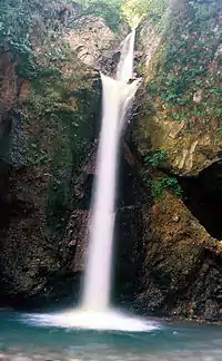
- Daisen Waterfall
- Remains of Sainō-ji
- Remains of Yabase Castle
- Kawamoto Family Residence
Notable people
- Tomoyuki Kawabata, cyclist (1985–)
- Yoshihiro Kawakami, politician (1950–)
- Kaori Kawanaka, archer (1991–)
- Shigeru Kobayashi, baseball pitcher (1952–2010)
- Teikō Shiotani, photographer (1899–1988)
References
- "Kotoura". Nihon Daihyakka Zensho (Nipponika) (日本大百科全書(ニッポニカ) “Large Encyclopedia of Japan (Nipponika)”) (in Japanese). Tokyo: Shogakukan. 2012. Archived from the original on 2007-08-25. Retrieved 2012-03-07.
External links
 Media related to Kotoura, Tottori at Wikimedia Commons
- Town of Kotoura (in Japanese)
| Core city | Flag of Tottori Prefecture | |
|---|---|---|
| Cities | ||
| Districts | ||