Daisen, Tottori
Daisen (大山町, Daisen-chō) is a town located in Saihaku District, Tottori Prefecture, Japan.
Daisen
大山町 | |||||||||||
|---|---|---|---|---|---|---|---|---|---|---|---|
Town | |||||||||||
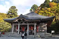 Daisen Temple | |||||||||||
 Flag | |||||||||||
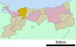 Location of Daisen in Tottori Prefecture | |||||||||||
 Daisen Location in Japan | |||||||||||
| Coordinates: 35°30′N 133°30′E | |||||||||||
| Country | Japan | ||||||||||
| Region | Chūgoku San'in | ||||||||||
| Prefecture | Tottori Prefecture | ||||||||||
| District | Saihaku | ||||||||||
| Government | |||||||||||
| • Mayor | Takayuki Yamaguchi (since April 2005) | ||||||||||
| Area | |||||||||||
| • Total | 189.83 km2 (73.29 sq mi) | ||||||||||
| Population (June 1, 2016) | |||||||||||
| • Total | 16,357 | ||||||||||
| • Density | 86.2/km2 (223/sq mi) | ||||||||||
| Time zone | UTC+09:00 (JST) | ||||||||||
| City hall address | 328 Mikushiya, Daisen, Saihaku-gun, Tottori-ken 689-3211 | ||||||||||
| Website | www | ||||||||||
| |||||||||||
As of June 1, 2016, Daisen had an estimated population of 16,357 and a population density of 86.2 persons per km². The total area is 189.79 square kilometres (73.28 sq mi). The town is known for Mount Daisen, the tallest mountain in the Chūgoku Region. The mountain was an early center of Shinto and Buddhist practice, and the town has numerous designated Cultural Properties of Japan.[1]
Geography
Daisen is located to the west of Saihaku District. The north of the town has a broad coast along the Japan Sea, and its inland area sweeps up to the Chūgoku Region, specifically Mount Daisen. The Amida River flows north towards the Sea of Japan and forms an alluvial delta in Daisen.[1]
History
The town of Daisen was formed from the merger of the towns of Nakayama and Nawa, both from Saihaku District, on March 28, 2005.
Sister city
The town is a sister city to Temecula, California.
References
- "大山町 (Daisen-chō)". Nihon Daihyakka Zensho (Nipponika) (日本大百科全書(ニッポニカ) (in Japanese). Tokyo: Shogakukan. 2012. Archived from the original on August 25, 2007. Retrieved 2012-04-27.
External links
| Wikimedia Commons has media related to Daisen, Tottori. |
 Daisen (Tottori) travel guide from Wikivoyage
- Official website (in Japanese)
- Daisen guide
| Core city | Flag of Tottori Prefecture | |
|---|---|---|
| Cities | ||
| Districts | ||
| Authority control |
|---|
