Yazu, Tottori
Yazu (八頭町, Yazu-chō) is a town located in Yazu District, Tottori Prefecture, Japan.
Yazu
八頭町 | |
|---|---|
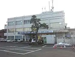 Yazu Town Hall | |
 Flag  Seal | |
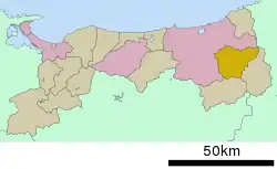 Location of Yazu in Tottori Prefecture | |
 Yazu | |
| Coordinates: 35°24′N 134°15′E | |
| Country | |
| Region | Chūgoku |
| Prefecture | |
| District | Yazu |
| Area | |
| • Total | 206.71 km2 (79.81 sq mi) |
| Population (October 1, 2015) | |
| • Total | 16,985 |
| • Density | 82.05/km2 (212.5/sq mi) |
| Time zone | UTC+9 (JST) |
| Postal code | 680-0493 |
| Symbols | |
| • Tree | Diospyros kaki |
| • Flower | Rhododendron indicum |
| Phone number | 0858-76-0201 |
| Address | 493 Kōge, Yazu-chō, Yazu-gun, Tottori-ken |
| Website | Official website |
As of October 1, 2015, the town has a population of 16,985 and a density of 82.05 per square kilometre (212.5/sq mi). The total area is 206.71 square kilometres (79.81 sq mi).
Yazu was formed on March 31, 2005, by the merger of the towns of Funaoka, Hattō and Kōge, all from Yazu District.[1][2]
Geography
Yazu is located to the far east of Tottori Prefecture. Its highest peak is Ōginosen (1,309.9 metres or 4,298 feet), which is located on the border of the city of Tottori, the towns of Misasa and Chizu, as well as Shin'onsen in Hyōgo Prefecture. Ōginosen is part of the Daisen Volcanic Belt. The mountain is part of Hyōnosen-Ushiroyama-Nagisan Quasi-National Park, and has facilities for skiing and camping.[3] The Hattō River (39.1 metres (128 ft)), the largest tributary of the Sendai River, flows through Yazu, as does a smaller tributary, the Kisaichi River (28.1 metres (92 ft)), which traces its origin to Ōginosen.[4][5]
Neighbouring municipalities
Parks
Hyōnosen-Ushiroyama-Nagisan Quasi-National Park, founded on April 10, 1969, spans across Hyōgo Prefecture, Tottori Prefecture, and Okayama Prefecture. Much of the area of the town of Yazu is included in the quasi-national park.[6][7]
Demography
Per Japanese census data,[8] the population of Yazu in recent years is as follows:
| 1995 | 2000 | 2005 | 2010 | 2015 |
|---|---|---|---|---|
| 20,806 | 20,245 | 19,434 | 18,427 | 16,985 |
Government
Yazu is governed by an 18-person town council, headed by a chairperson and vice-chairperson.[9] Makoto Hiraki has served as mayor of Yazu since the founding of the town in 2005.[2] Yazu maintains a municipal board of education, as well as a police and fire department.
References
- "八頭町" [Yazu-chō]. Nihon Daihyakka Zensho (Nipponika) (in Japanese). Tokyo: Shogakukan. 2012. OCLC 153301537. Retrieved 2012-05-28.
- まちの概要 [Overview of Yazu] (in Japanese). Yazu, Tottori Prefecture: Yazu-Town. 2012. Retrieved July 18, 2012.
- "扇ノ山" [Ōginosen]. Nihon Daihyakka Zensho (Nipponika) (in Japanese). Tokyo: Shogakukan. 2012. OCLC 153301537. Retrieved 2012-05-28.
- "Hattō River" [Kisaichi River]. Nihon Rekishi Chimei Taikei (in Japanese). Tokyo: Shogakukan. 2012. OCLC 173191044. DLC 2009238904. Retrieved 2012-06-02.
- "私都川" [Kisaichi River]. Nihon Rekishi Chimei Taikei (in Japanese). Tokyo: Shogakukan. 2012. OCLC 173191044. DLC 2009238904. Retrieved 2012-06-02.
- "氷ノ山後山那岐山国定公園". Ministry of the Environment. Archived from the original on May 23, 2011. Retrieved 13 July 2019.
- "丹後天橋立大江山/明治の森箕面/金剛生駒紀泉/氷ノ山後山那岐山". National Parks Association of Japan. Retrieved 10 May 2011.
- Yazu population statistics
- 町議会の仕組み・構成 [Structure and Organization of the Town Council] (in Japanese). Yazu, Tottori Prefecture: Yazu-Town. 2012. Retrieved July 18, 2012.
External links
 Media related to Yazu, Tottori at Wikimedia Commons
- Yazu official website (in Japanese)
| Core city | Flag of Tottori Prefecture | |
|---|---|---|
| Cities | ||
| Districts | ||
| Authority control |
|---|