Volcanism of Iceland
The volcanoes of Iceland include a high concentration of active ones due to Iceland's location on the Mid-Atlantic Ridge, a divergent tectonic plate boundary, and its location over a hot spot.
- The volcano system in Iceland that started activity on August 17, 2014, and ended on February 27, 2015, is Bárðarbunga.
- The volcano in Iceland that erupted in May 2011 is Grímsvötn.
Volcanic systems and volcanic zones of Iceland
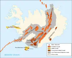
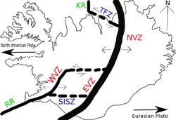
Holocene volcanism in Iceland is mostly to be found in the Neovolcanic Zone, comprising the Reykjanes Volcanic Belt (RVB), the West Volcanic Zone (WVZ), the Mid-Iceland Belt (MIB), the East Volcanic Zone (EVZ) and the North Volcanic Zone (NVZ). Two lateral volcanic zones play a minor role: Öræfi Volcanic Belt (ÖVB) and Snæfellsnes Volcanic Belt (SVB).[1] Outside of the main island are the Reykjanes Ridge (RR), as part of the Mid-Atlantic Ridge to the southwest and the Kolbeinsey Ridge (KR) to the north. Two transform zones are connecting these volcano-tectonic zones: the South Iceland Seismic Zone (SISZ) in the south of Iceland and the Tjörnes Transform Zone (TFZ) in the north.
The island has around 30 active volcanic systems, comprising each volcano-tectonic fissure systems and many of them also a central volcano (mostly in the form of a stratovolcano, sometimes of a shield volcano with a magma chamber underneath). 13 volcanic systems have hosted eruptions since the settlement of Iceland in AD 874.[2]
Of these 30 active volcanic systems, the most active is Grímsvötn.[3] Over the past 500 years, Iceland's volcanoes have produced a third of the total global lava output.[4]
Important eruptions
Laki/Skaftáreldar 1783-84
The most fatal volcanic eruption of Iceland's history was the so-called Skaftáreldar (fires of Skaftá) in 1783–84. The eruption was in the crater row Lakagígar (craters of Laki) southwest of Vatnajökull glacier. The craters are a part of a larger volcanic system with the subglacial Grímsvötn as a central volcano. Roughly a quarter of the Icelandic nation died because of the eruption. Most died not because of the lava flow or other direct effects of the eruption, but from indirect effects, including changes in climate and illnesses in livestock in the following years caused by the ash and poisonous gases from the eruption. The 1783 eruption in Lakagígar is thought to have erupted the largest quantity of lava from a single eruption in historic times.
Eyjafjallajökull 2010
The eruption under Eyjafjallajökull ("glacier of Eyjafjöll") in April 2010 was notable for causing enormous disruption to air travel across western and northern Europe over a period of six days in April 2010. About 20 countries closed their airspace to commercial jet traffic and it affected approximately 10 million travellers.[5]
However this volcano is minor in Icelandic terms (VEI4)[6] In the past, eruptions of Eyjafjallajökull have been followed by eruption of the larger volcano Katla, but after the 2010 eruption no signs of an imminent eruption of Katla were seen. [7]
Grímsvötn 2011
The eruption in May 2011 at Grímsvötn under the Vatnajökull glacier sent thousands of tonnes of ash into the sky in a few days, raising concerns of a repeat of the travel chaos seen across northern Europe.
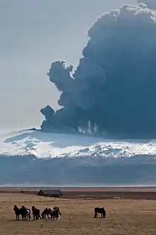
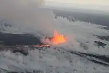
Bárðarbunga 2014–2015
Bárðarbunga is a stratovolcano and is roughly 2,000 meters (roughly 6,560 feet) above sea level in central Iceland (64.63°N / -17.53°W).[8] This makes it the second highest mountain in Iceland.
The eruption series, Iceland's largest eruptions in 230 years[9] that started on August 17, 2014 and lasted for 180 days,[10] under the Bárðarbunga system started with an extremely heavy earthquake swarm followed by clusters of volcanic activity that went on for an extended period. This resulted in multiple lava fountain eruptions in Holuhraun.[11] Lava flow was between 250 and 350 cubic meters per second and came from a dyke over 40 km long.[12][13] An ice-filled subsidence bowl over 100 square kilometers in area and up to 65 meters deep formed as well.[14] There was very limited ash output from this eruption unlike numerous glacial eruptions which are common in Iceland. The primary concern with this eruption was the large plumes of sulphur dioxide (SO2) in the atmosphere which adversely affected breathing conditions across Iceland, depending on wind direction. The volcanic cloud was also transported toward Western Europe in September 2014.[15]
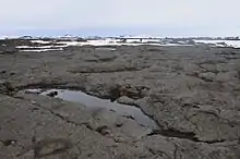
Structure of lava fields
The smooth flowing basaltic lava pāhoehoe is in Iceland called helluhraun.[Islandsbok 1] It forms rather flat surfaces that are quite easy to pass.
.jpg.webp)
On the other hand, there is less flowing lava, ʻaʻā, on Iceland called apalhraun.[Islandsbok 1] The loose, broken, sharp, spiny surface of an ʻaʻā flow makes hiking difficult and slow.
See also
Notes
- Thor Thordarson, Armann Hoskuldsson: Iceland. Classic geology of Europe 3. Harpenden 2002, p. 9
- Thordarson, Th; Hoskuldsson, A (2008). "Postglacial Volcanism in Iceland" (PDF). Jökull. 58: 197–228.
- Gudmundsson, Magnus Tumi; Larsen, G; Hoskuldsson, A; Gylfason, A.G. (2008). "Volcanic Hazards in Iceland". Jökull. 58: 251–268.
- Waugh, David (2002). Geography: An Integrated Approach. United Kingdom: Nelson Thornes. p. 16. ISBN 978-0-17-444706-1.
- Bye, Bente Lilja (27 May 2011). "Volcanic eruptions: Science and Risk Management". Science 2.0. Retrieved 28 May 2011.
- Eyjafjallajökull. Eruptive History. Global Volcanism Program. Accessed 19 August 2020.
- Katla. Detailed description. In: Catalogue of Icelandic Volcanoes. Accessed 19 August 2020
- "Bardarbunga". www.volcanodiscovery.com. Retrieved 2017-10-06.
- Hudson, T. S.; White, R. S.; Greenfield, T.; Ágústsdóttir, T.; Brisbourne, A.; Green, R. G. (2017-09-16). "Deep crustal melt plumbing of Bárðarbunga volcano, Iceland" (PDF). Geophysical Research Letters. 44 (17): 2017GL074749. Bibcode:2017GeoRL..44.8785H. doi:10.1002/2017gl074749. ISSN 1944-8007.
- Gudmundsson, Magnús T.; Jónsdóttir, Kristín; Hooper, Andrew; Holohan, Eoghan P.; Halldórsson, Sæmundur A.; Ófeigsson, Benedikt G.; Cesca, Simone; Vogfjörd, Kristín S.; Sigmundsson, Freysteinn (2016-07-15). "Gradual caldera collapse at Bárdarbunga volcano, Iceland, regulated by lateral magma outflow" (PDF). Science. 353 (6296): aaf8988. doi:10.1126/science.aaf8988. ISSN 0036-8075. PMID 27418515. S2CID 206650214.
- "Ljós norðan jökuls: Töldu annað gos hafið". www.ruv.is/. RÚV. Retrieved 24 September 2014.
- See e.g. http://earthice.hi.is/bardarbunga_2014 Institute of Earth Sciences, University of Iceland:Bardarbunga 2014
- See also Icelandic media RÚV: http://www.ruv.is/frett/seismic-activity-still-strong Received Sept. 24, 2014
- Gudmundsson, Magnús T.; Jónsdóttir, Kristín; Hooper, Andrew; Holohan, Eoghan P.; Halldórsson, Sæmundur A.; Ófeigsson, Benedikt G.; Cesca, Simone; Vogfjörd, Kristín S.; Sigmundsson, Freysteinn (2016-07-15). "Gradual caldera collapse at Bárdarbunga volcano, Iceland, regulated by lateral magma outflow" (PDF). Science. 353 (6296): aaf8988. doi:10.1126/science.aaf8988. ISSN 0036-8075. PMID 27418515. S2CID 206650214.
- Boichu, M.; Chiapello, I.; Brogniez, C.; Péré, J.-C.; Thieuleux, F.; Torres, B.; Blarel, L.; Mortier, A.; Podvin, T. (2016-08-31). "Current challenges in modelling far-range air pollution induced by the 2014–2015 Bárðarbunga fissure eruption (Iceland)". Atmos. Chem. Phys. 16 (17): 10831–10845. Bibcode:2016ACP....1610831B. doi:10.5194/acp-16-10831-2016. ISSN 1680-7324.
- Lidén, Eva (1994). "Geologi-så bildades Island". Kall ökensand och varma källor. En bok om Island (in Swedish). Båstad: Föreningen Natur och Samhälle i Norden. pp. 8–9. ISBN 978-91-85586-07-3.
External links
- Photos of the Grímsvötn (2004) and Eyjafjallajökull (2010) eruptions (Fred Kamphues)
- Map: active volcanoes of the world
- Icelandic Video Archive
- Volcano Discovery: Iceland
- List of volcanic eruptions in Iceland since 1900, Icelandic Met Office