La Feuillée
La Feuillée (Breton: Ar Fouilhez) is a commune in the Finistère department of Brittany in north-western France.
La Feuillée
Ar Fouilhez | |
|---|---|
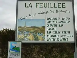 La Feuillée, the highest village in Brittany | |
.svg.png.webp) Coat of arms | |
Location of La Feuillée 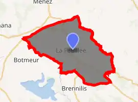
| |
 La Feuillée  La Feuillée | |
| Coordinates: 48°23′33″N 3°51′08″W | |
| Country | France |
| Region | Brittany |
| Department | Finistère |
| Arrondissement | Châteaulin |
| Canton | Carhaix-Plouguer |
| Intercommunality | Yeun Elez |
| Government | |
| • Mayor (2014–2020) | Régis Le Goff |
| Area 1 | 31.55 km2 (12.18 sq mi) |
| Population (2017-01-01)[1] | 641 |
| • Density | 20/km2 (53/sq mi) |
| Time zone | UTC+01:00 (CET) |
| • Summer (DST) | UTC+02:00 (CEST) |
| INSEE/Postal code | 29054 /29690 |
| Elevation | 192–381 m (630–1,250 ft) |
| 1 French Land Register data, which excludes lakes, ponds, glaciers > 1 km2 (0.386 sq mi or 247 acres) and river estuaries. | |
Population
Inhabitants of La Feuillée are called in French Feuillantins.
|
|
|
References
- "Populations légales 2017". INSEE. Retrieved 6 January 2020.
External links
| Wikimedia Commons has media related to La Feuillée. |
- Official website (in French)
- Base Mérimée: Search for heritage in the commune, Ministère français de la Culture. (in French)
- Mayors of Finistère Association (in French)
| Authority control |
|---|
This article is issued from Wikipedia. The text is licensed under Creative Commons - Attribution - Sharealike. Additional terms may apply for the media files.