Saint-Eloy, Finistère
Saint-Eloy (Breton: Sant-Alar) is a commune in the Finistère department of Brittany in north-western France.
Saint-Eloy
Sant-Alar | |
|---|---|
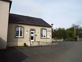 The town hall in Saint-Eloy | |
.svg.png.webp) Coat of arms | |
Location of Saint-Eloy 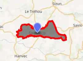
| |
 Saint-Eloy  Saint-Eloy | |
| Coordinates: 48°21′44″N 4°07′16″W | |
| Country | France |
| Region | Brittany |
| Department | Finistère |
| Arrondissement | Brest |
| Canton | Pont-de-Buis-lès-Quimerch |
| Intercommunality | Pays de Landerneau-Daoulas |
| Government | |
| • Mayor (2014–2020) | Gilles Tandéo |
| Area 1 | 12.42 km2 (4.80 sq mi) |
| Population (2017-01-01)[1] | 214 |
| • Density | 17/km2 (45/sq mi) |
| Time zone | UTC+01:00 (CET) |
| • Summer (DST) | UTC+02:00 (CEST) |
| INSEE/Postal code | 29246 /29460 |
| Elevation | 65–298 m (213–978 ft) |
| 1 French Land Register data, which excludes lakes, ponds, glaciers > 1 km2 (0.386 sq mi or 247 acres) and river estuaries. | |
History
In 1521, the monks of the Abbey of Daoulas, fleeing the plague, took refuge in Fresq (former name of the town) and build a chapel there, which stood today as the church of Saint-Eloy. The name Saint-Eloy came from Saint Eligius.[2]
Sights
References
- "Populations légales 2017". INSEE. Retrieved 6 January 2020.
- "Commune de Saint Eloy, pays de Landerneau-Daoulas". 2004-05-30. Retrieved 2018-11-10.
External links
| Wikimedia Commons has media related to Saint-Eloy (Finistère). |
- Official website (in French)
- Mayors of Finistère Association (in French)
| Authority control |
|---|
This article is issued from Wikipedia. The text is licensed under Creative Commons - Attribution - Sharealike. Additional terms may apply for the media files.