La Longine
La Longine is a commune in the Haute-Saône department in the region of Bourgogne-Franche-Comté in eastern France.
La Longine | |
|---|---|
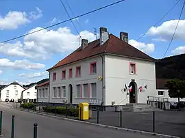 The town hall in La Longine | |
 Coat of arms | |
Location of La Longine 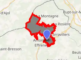
| |
 La Longine  La Longine | |
| Coordinates: 47°53′04″N 6°35′29″E | |
| Country | France |
| Region | Bourgogne-Franche-Comté |
| Department | Haute-Saône |
| Arrondissement | Lure |
| Canton | Mélisey |
| Area 1 | 12.40 km2 (4.79 sq mi) |
| Population (2017-01-01)[1] | 226 |
| • Density | 18/km2 (47/sq mi) |
| Time zone | UTC+01:00 (CET) |
| • Summer (DST) | UTC+02:00 (CEST) |
| INSEE/Postal code | 70308 /70310 |
| Elevation | 395–770 m (1,296–2,526 ft) |
| 1 French Land Register data, which excludes lakes, ponds, glaciers > 1 km2 (0.386 sq mi or 247 acres) and river estuaries. | |
The village of La Longine is a small village located east of France. It is located in the canton of Mélisey and of the arrondissement of Lure. The area code for La Longine is 70308 (also known as code INSEE), and the zip code is 70310.
Demography
The population of La Longine was 255 in 2007 and the population density was 20.56 inhabitants per km². The number of housing units in La Longine was 162 in 2007. These homes consist of 113 residences, 37 second or occasional homes and 12 vacant homes.
References
- "Populations légales 2017". INSEE. Retrieved 6 January 2020.
| Wikimedia Commons has media related to La Longine. |
| Authority control |
|---|
This article is issued from Wikipedia. The text is licensed under Creative Commons - Attribution - Sharealike. Additional terms may apply for the media files.