Mailleroncourt-Saint-Pancras
Mailleroncourt-Saint-Pancras is a commune in the Haute-Saône department in the region of Bourgogne-Franche-Comté in eastern France.
Mailleroncourt-Saint-Pancras | |
|---|---|
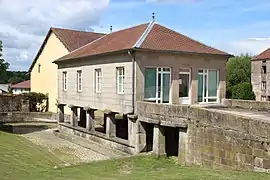 The town hall and wash house in Mailleroncourt-Saint-Pancras | |
Location of Mailleroncourt-Saint-Pancras 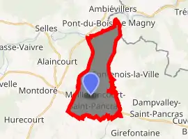
| |
 Mailleroncourt-Saint-Pancras  Mailleroncourt-Saint-Pancras | |
| Coordinates: 47°55′07″N 6°07′58″E | |
| Country | France |
| Region | Bourgogne-Franche-Comté |
| Department | Haute-Saône |
| Arrondissement | Lure |
| Canton | Port-sur-Saône |
| Area 1 | 14.90 km2 (5.75 sq mi) |
| Population (2017-01-01)[1] | 192 |
| • Density | 13/km2 (33/sq mi) |
| Time zone | UTC+01:00 (CET) |
| • Summer (DST) | UTC+02:00 (CEST) |
| INSEE/Postal code | 70323 /70210 |
| Elevation | 237–331 m (778–1,086 ft) |
| 1 French Land Register data, which excludes lakes, ponds, glaciers > 1 km2 (0.386 sq mi or 247 acres) and river estuaries. | |
Geography
The Côney forms most of the commune's northern border.
References
- "Populations légales 2017". INSEE. Retrieved 6 January 2020.
| Wikimedia Commons has media related to Mailleroncourt-Saint-Pancras. |
| Authority control |
|---|
This article is issued from Wikipedia. The text is licensed under Creative Commons - Attribution - Sharealike. Additional terms may apply for the media files.
