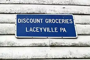
Laceyville, Pennsylvania
Laceyville is a borough in Wyoming County, Pennsylvania, United States. The population was 379 at the 2010 census.
Borough of Laceyville | |
|---|---|
 Location of Laceyville in Wyoming County, Pennsylvania. | |
 Laceyville Location of Laceyville in Pennsylvania  Laceyville Laceyville (the United States) | |
| Coordinates: 41°38′43″N 76°09′38″W | |
| Country | United States |
| State | Pennsylvania |
| County | Wyoming |
| Government | |
| • Mayor | Randy Brigham |
| Area | |
| • Total | 0.20 sq mi (0.52 km2) |
| • Land | 0.19 sq mi (0.50 km2) |
| • Water | 0.01 sq mi (0.02 km2) |
| Elevation | 620 ft (190 m) |
| Population (2010) | |
| • Total | 379 |
| • Estimate (2019)[2] | 348 |
| • Density | 1,803.11/sq mi (695.13/km2) |
| Time zone | UTC-5 (EST) |
| • Summer (DST) | UTC-4 (EDT) |
| ZIP Code | 18623 |
| Area code(s) | 570 Exchange: 869 |
| FIPS code | 42-40744 |
| Website | www |
Geography
Laceyville is located at 41°38′43″N 76°9′38″W (41.645337, -76.160451).[3]
According to the United States Census Bureau, the borough has a total area of 0.2 square miles (0.52 km2), all of it land.
Demographics
| Historical population | |||
|---|---|---|---|
| Census | Pop. | %± | |
| 1910 | 479 | — | |
| 1920 | 466 | −2.7% | |
| 1930 | 467 | 0.2% | |
| 1940 | 491 | 5.1% | |
| 1950 | 505 | 2.9% | |
| 1960 | 468 | −7.3% | |
| 1970 | 452 | −3.4% | |
| 1980 | 498 | 10.2% | |
| 1990 | 436 | −12.4% | |
| 2000 | 396 | −9.2% | |
| 2010 | 379 | −4.3% | |
| 2019 (est.) | 348 | [2] | −8.2% |
| Sources:[4][5][6] | |||
At the 2000 census,[7] there were 379 people, 160 households and 102 families residing in the borough. The population density was 1,895 per square mile (731.7/km2). There were 185 housing units at an average density of 925 per square mile (361.3/km2). The racial makeup of the borough was 94.5% White, 0.5% African American, 4.7% some other race, and 0.3% from two or more races. Hispanic or Latino of any race were 7.9% of the population.
There were 160 households, of which 32.5% had children under the age of 18 living with them, 44.4% were married couples living together, 13.1% had a female householder with no husband present, and 36.3% were non-families. 32.5% of all households were made up of individuals, and 12.5% had someone living alone who was 65 years of age or older. The average household size was 2.37 and the average family size was 2.89.
23.7% of the population were under the age of 18, 61.8% from 18 to 64, and 14.5% who were 65 years of age or older. The median age was 39.4 years.
The median household income was $46,667 and the median family income was $58,542. Males had a median income of $32,125 and females $25,000. The per capita income was $18,594. About 14.4% of families and 15.1% of the population were below the poverty line, including 22.6% of those under age 18 and 18.2% of those age 65 or over.
References
- "2019 U.S. Gazetteer Files". United States Census Bureau. Retrieved July 28, 2020.
- "Population and Housing Unit Estimates". United States Census Bureau. May 24, 2020. Retrieved May 27, 2020.
- "US Gazetteer files: 2010, 2000, and 1990". United States Census Bureau. 2011-02-12. Retrieved 2011-04-23.
- "Census of Population and Housing". U.S. Census Bureau. Retrieved 11 December 2013.
- "U.S. Census website". United States Census Bureau. Retrieved 2008-01-31.
- "Incorporated Places and Minor Civil Divisions Datasets: Subcounty Resident Population Estimates: April 1, 2010 to July 1, 2012". Population Estimates. U.S. Census Bureau. Archived from the original on 11 June 2013. Retrieved 11 December 2013.
- "U.S. Census website". United States Census Bureau. Retrieved 2011-05-14.
External links
Municipalities and communities of Wyoming County, Pennsylvania, United States | ||
|---|---|---|
| Boroughs | 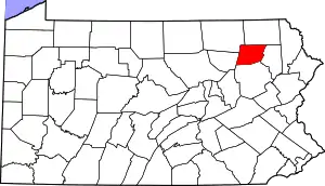 | |
| Townships | ||
| CDPs | ||
| Unincorporated communities | ||
| Ghost town | ||
| ||
| Authority control |
|---|