Wyoming County, Pennsylvania
Wyoming County is a county located in the U.S. state of Pennsylvania. As of the 2010 census, the population was 28,276.[1] Its county seat is Tunkhannock.[2] It was created in 1842 from part of Luzerne County.
Wyoming County | |
|---|---|
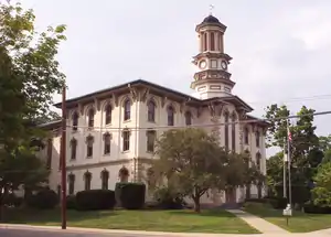 The Wyoming County courthouse in Tunkhannock | |
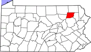 Location within the U.S. state of Pennsylvania | |
 Pennsylvania's location within the U.S. | |
| Coordinates: 41°31′N 76°01′W | |
| Country | |
| State | |
| Founded | April 4, 1842 |
| Named for | Wyoming Valley |
| Seat | Tunkhannock |
| Largest borough | Tunkhannock |
| Area | |
| • Total | 405 sq mi (1,050 km2) |
| • Land | 397 sq mi (1,030 km2) |
| • Water | 7.7 sq mi (20 km2) 1.9% |
| Population | |
| • Estimate (2018) | 27,046 |
| • Density | 70/sq mi (30/km2) |
| Time zone | UTC−5 (Eastern) |
| • Summer (DST) | UTC−4 (EDT) |
| Congressional district | 12th |
| Website | www |
Wyoming County is included in the Scranton—Wilkes-Barre—Hazleton, PA Metropolitan Statistical Area.
Geography
According to the U.S. Census Bureau, the county has a total area of 405 square miles (1,050 km2), of which 397 square miles (1,030 km2) is land and 7.7 square miles (20 km2) (1.9%) is water.[3] The county is intersected by the North Branch of the Susquehanna River, and drained by Tunkhannock, Mehoopany, and other large creeks. The land surface is generally hilly or mountainous, Mehoopany, Tunkhannock, Knob, and Bowman's mountains occupying a portion. The soil is fertile. Timber, coal, and iron are very abundant.[4]
Climate
The county has a humid continental climate which is warm-summer (Dfb) except along the river starting below Falls where it is hot-summer (Dfa). Average monthly temperatures in Tunkhannock range from 25.2 °F in January to 70.9 °F in July.
Adjacent counties
- Susquehanna County (north)
- Lackawanna County (east)
- Luzerne County (south)
- Sullivan County (west)
- Bradford County (northwest)
Demographics
| Historical population | |||
|---|---|---|---|
| Census | Pop. | %± | |
| 1850 | 10,655 | — | |
| 1860 | 12,540 | 17.7% | |
| 1870 | 14,585 | 16.3% | |
| 1880 | 15,598 | 6.9% | |
| 1890 | 15,891 | 1.9% | |
| 1900 | 17,152 | 7.9% | |
| 1910 | 15,509 | −9.6% | |
| 1920 | 14,101 | −9.1% | |
| 1930 | 15,517 | 10.0% | |
| 1940 | 16,702 | 7.6% | |
| 1950 | 16,766 | 0.4% | |
| 1960 | 16,813 | 0.3% | |
| 1970 | 19,082 | 13.5% | |
| 1980 | 26,433 | 38.5% | |
| 1990 | 28,076 | 6.2% | |
| 2000 | 28,080 | 0.0% | |
| 2010 | 28,276 | 0.7% | |
| 2018 (est.) | 27,046 | [5] | −4.3% |
| U.S. Decennial Census[6] 1790-1960[7] 1900-1990[8] 1990-2000[9] 2010-2017[1] | |||
As of the census[10] of 2000, there were 28,080 people, 10,762 households, and 7,705 families residing in the county. The population density was 71 people per square mile (27/km2). There were 12,713 housing units at an average density of 32 per square mile (12/km2). The racial makeup of the county was 98.28% White, 0.53% Black or African American, 0.27% Asian, 0.17% Native American, 0.01% Pacific Islander, 0.15% from other races, and 0.59% from two or more races. 0.67% of the population were Hispanic or Latino of any race. 20.3% were of German, 12.9% Irish, 11.9% English, 11.6% Polish, 9.6% American and 8.1% Italian ancestry.
There were 10,762 households, out of which 33.20% had children under the age of 18 living with them, 58.10% were married couples living together, 9.30% had a female householder with no husband present, and 28.40% were non-families. 24.10% of all households were made up of individuals, and 9.90% had someone living alone who was 65 years of age or older. The average household size was 2.55 and the average family size was 3.02.
In the county, the population was spread out, with 25.50% under the age of 18, 8.00% from 18 to 24, 28.10% from 25 to 44, 25.20% from 45 to 64, and 13.20% who were 65 years of age or older. The median age was 38 years. For every 100 females there were 98.60 males. For every 100 females age 18 and over, there were 95.80 males.
Politics
| Year | Republican | Democratic | Third parties |
|---|---|---|---|
| 2016 | 66.7% 8,837 | 28.8% 3,811 | 4.6% 607 |
| 2012 | 55.3% 6,587 | 42.5% 5,061 | 2.3% 273 |
| 2008 | 52.8% 6,983 | 45.3% 5,985 | 1.9% 255 |
| 2004 | 60.7% 7,782 | 38.8% 4,982 | 0.5% 68 |
| 2000 | 59.1% 6,922 | 37.3% 4,363 | 3.6% 424 |
| 1996 | 47.0% 4,888 | 38.9% 4,049 | 14.1% 1,471 |
| 1992 | 47.4% 5,143 | 29.1% 3,158 | 23.5% 2,549 |
| 1988 | 69.9% 6,607 | 29.6% 2,797 | 0.5% 43 |
| 1984 | 74.0% 7,230 | 25.8% 2,518 | 0.2% 21 |
| 1980 | 64.6% 5,919 | 30.2% 2,766 | 5.3% 482 |
| 1976 | 60.3% 5,705 | 38.4% 3,628 | 1.3% 122 |
| 1972 | 74.4% 6,423 | 24.5% 2,112 | 1.1% 96 |
| 1968 | 64.1% 5,207 | 29.1% 2,366 | 6.8% 551 |
| 1964 | 47.5% 3,864 | 52.4% 4,268 | 0.2% 12 |
| 1960 | 69.4% 6,188 | 30.6% 2,726 | 0.1% 7 |
| 1956 | 73.6% 5,906 | 26.4% 2,120 | 0.0% 3 |
| 1952 | 75.7% 5,772 | 23.8% 1,815 | 0.5% 36 |
| 1948 | 70.7% 4,332 | 27.3% 1,674 | 2.0% 121 |
| 1944 | 69.6% 4,581 | 30.1% 1,982 | 0.3% 19 |
| 1940 | 67.1% 5,273 | 32.4% 2,548 | 0.4% 33 |
| 1936 | 61.3% 5,321 | 37.6% 3,269 | 1.1% 97 |
| 1932 | 58.0% 3,968 | 39.9% 2,728 | 2.1% 145 |
| 1928 | 85.0% 5,321 | 14.5% 906 | 0.5% 33 |
| 1924 | 68.1% 3,213 | 25.3% 1,194 | 6.7% 314 |
| 1920 | 68.4% 3,208 | 26.6% 1,247 | 5.0% 233 |
| 1916 | 52.1% 1,698 | 44.3% 1,444 | 3.6% 116 |
| 1912 | 13.6% 480 | 42.6% 1,505 | 43.8% 1,548[12] |
| 1908 | 55.8% 2,234 | 40.7% 1,629 | 3.5% 141 |
| 1904 | 56.9% 2,308 | 38.8% 1,575 | 4.3% 173 |
| 1900 | 52.6% 2,247 | 43.9% 1,875 | 3.5% 149 |
| 1896 | 53.2% 2,373 | 43.8% 1,951 | 3.0% 133 |
| 1892 | 49.8% 2,029 | 46.8% 1,905 | 3.4% 139 |
| 1888 | 50.7% 2,026 | 46.1% 1,841 | 3.2% 129 |
As of August 2020, there were. 17,582 registered voters in Wyoming County.
- Democratic: 5,248
- Republican: 10,299
- Other Parties: 2,035
County commissioners
- Richard Wilbur, Chair, Republican
- Thomas Henry, Vice-chair, Republican
- Ernest King, Democrat
Other county offices
- Auditors:
- Laura Dickson, Democrat
- Ashley Ritz Darby, Republican
- Judy Shupp, Republican
- District Attorney, Jeff Mitchell, Democrat
- Prothonotary, Cindy Adams, Republican
- Register of Wills & Recorder of Deeds, Dennis Montross, Republican
- Sheriff, Robert Roberts, Republican
- Treasurer, Patricia Mead, Republican
State Representative
- Karen Boback, Republican, 117th district
State Senator
- Lisa Baker, Republican, 20th district
United States House of Representatives
- Fred Keller, Republican, Pennsylvania's 12th congressional district
United States Senator
- Robert Casey Jr., Democrat
- Pat Toomey, Republican
Education
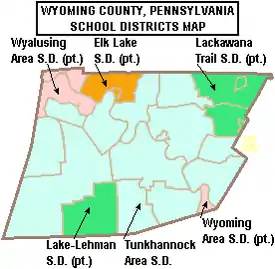
Public school districts
- Elk Lake School District (also in Susquehanna County)
- Lackawanna Trail School District (also in Lackawanna County)
- Lake-Lehman School District (also in Luzerne County)
- Tunkhannock Area School District
- Wyalusing Area School District (also in Bradford County)
- Wyoming Area School District (also in Luzerne County)
Higher education
- Keystone College (also in Lackawanna County)
Transportation
Skyhaven Airport is a public use airport located in Wyoming County, one nautical mile (1.85 km) south of the central business district of Tunkhannock.[13]
With the town sited on the lower end of the upper third of the Susquehanna, busily wending its way south to the Chesapeake Bay, the river banks to either side the whole length of the Susquehanna were historically used as a rail transport corridor with competing railroads typically making their way on either side on the important NYC and Philadelphia to Buffalo, New York routes connecting the eastern seaboard to cities such as Chicago on the Great Lakes; towns like Tunkhannock played an important role in the highly competitive stakes for such high profit passenger expresses for steam locomotives had surprisingly short cruising ranges and passenger travel had higher earnings than freight. Today, except for select parts, the river bank rail transport infrastructures remaining are mainly left bank located assets of a single railroad's operations department, even shared roads (operated over by several lines) these days use the single corridor along the east/left river bank connecting the large Sayre Yard on the stateline in Sayre, Pennsylvania further upriver to the transitional Duryea yard. After the collapse of Conrail, trackage on the Northern Susquehanna is operated by Norfolk Southern, with some areas sublet to other road companies. The trackage running through Tunkhannock
Pennsylvania Route 29 ('PA-29', a continuation of PA-309 from Philadelphia and Allentown) connects to the New York state line providing north–south road connections by secondary highway, whilst PA-92, and especially U.S. Route 6 (US-6) provide major east–west secondary highway access to the region.
Communities
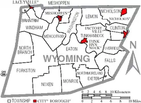
Under Pennsylvania law, there are four types of incorporated municipalities: cities, boroughs, townships, and, in at most two cases, towns. The following boroughs and townships are located in Wyoming County:
Boroughs
- Factoryville
- Laceyville
- Meshoppen
- Nicholson
- Tunkhannock (county seat)
Townships
Census-designated places
Unincorporated communities
Ghost towns
Population ranking
The population ranking of the following table is based on the 2010 census of Wyoming County.[14]
† county seat
| Rank | City/Town/etc. | Municipal type | Population (2010 Census) |
|---|---|---|---|
| 1 | † Tunkhannock | Borough | 1,836 |
| 2 | Factoryville | Borough | 1,158 |
| 3 | Nicholson | Borough | 767 |
| 4 | Lake Winola | CDP | 748 |
| 5 | Noxen | CDP | 633 |
| 6 | Meshoppen | Borough | 563 |
| 7 | West Falls | CDP | 382 |
| 8 | Laceyville | Borough | 379 |
References
- "State & County QuickFacts". United States Census Bureau. Archived from the original on June 6, 2011. Retrieved November 22, 2013.
- "Find a County". National Association of Counties. Archived from the original on May 31, 2011. Retrieved June 7, 2011.
- "2010 Census Gazetteer Files". United States Census Bureau. August 22, 2012. Retrieved March 11, 2015.
- Ripley, George; Dana, Charles A., eds. (1879). . The American Cyclopædia.
- "Population and Housing Unit Estimates". Retrieved October 18, 2018.
- "U.S. Decennial Census". United States Census Bureau. Retrieved March 11, 2015.
- "Historical Census Browser". University of Virginia Library. Archived from the original on August 11, 2012. Retrieved March 11, 2015.
- Forstall, Richard L., ed. (March 24, 1995). "Population of Counties by Decennial Census: 1900 to 1990". United States Census Bureau. Archived from the original on March 20, 2015. Retrieved March 11, 2015.
- "Census 2000 PHC-T-4. Ranking Tables for Counties: 1990 and 2000" (PDF). United States Census Bureau. April 2, 2001. Archived (PDF) from the original on December 18, 2014. Retrieved March 11, 2015.
- "U.S. Census website". United States Census Bureau. Retrieved 2011-05-14.
- Leip, David. "Dave Leip's Atlas of U.S. Presidential Elections". uselectionatlas.org. Archived from the original on March 23, 2018. Retrieved May 6, 2018.
- The leading "other" candidate, Progressive Theodore Roosevelt, received 1,464 votes, while Prohibition candidate Eugene Chafin received 51 votes, and Socialist Labor candidate Arthur Reimer received 33 votes.
- FAA Airport Form 5010 for 76N PDF. Federal Aviation Administration. Effective February 11, 2010.
- "2010 U.S. Census website". United States Census Bureau. Retrieved February 10, 2013.
External links
- Wyoming County official site
- Wyoming County Chamber of Commerce
- Wyoming County Historical Society
- Wyoming County United Way
Municipalities and communities of Wyoming County, Pennsylvania, United States | ||
|---|---|---|
| Boroughs | | |
| Townships | ||
| CDPs | ||
| Unincorporated communities | ||
| Ghost town | ||
| ||

| Authority control |
|---|