Meshoppen, Pennsylvania
Meshoppen is a borough in Wyoming County, Pennsylvania, United States. The population was 563 at the 2010 census.
Borough of Meshoppen | |
|---|---|
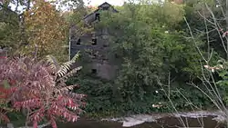 Meshoppen's Old White Mill | |
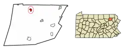 Location of Meshoppen in Wyoming County, Pennsylvania. | |
 Meshoppen Location of Meshoppen in Pennsylvania  Meshoppen Meshoppen (the United States) | |
| Coordinates: 41°36′53″N 76°02′47″W | |
| Country | United States |
| State | Pennsylvania |
| County | Wyoming |
| Founded by | A Sterling |
| Government | |
| • Mayor | Chris R. Baker |
| Area | |
| • Total | 0.78 sq mi (2.02 km2) |
| • Land | 0.69 sq mi (1.79 km2) |
| • Water | 0.09 sq mi (0.24 km2) |
| Elevation | 623 ft (190 m) |
| Population (2010) | |
| • Total | 563 |
| • Estimate (2019)[2] | 535 |
| • Density | 774.24/sq mi (299.05/km2) |
| Time zone | UTC-5 (EST) |
| • Summer (DST) | UTC-4 (EDT) |
| ZIP Code | 18630 |
| Area code(s) | 570 Exchange: 833 |
| FIPS code | 42-48856 |
| Website | www |
History
The borough takes its name from Meshoppen Creek, a Native American name purported to mean "glass beads".[3]
The Old White Mill was listed on the National Register of Historic Places in 1975.[4]
Geography
According to the United States Census Bureau, the borough has a total area of 0.7 square miles (1.8 km2), all of it land.
Demographics
| Historical population | |||
|---|---|---|---|
| Census | Pop. | %± | |
| 1880 | 554 | — | |
| 1890 | 597 | 7.8% | |
| 1900 | 609 | 2.0% | |
| 1910 | 630 | 3.4% | |
| 1920 | 608 | −3.5% | |
| 1930 | 525 | −13.7% | |
| 1940 | 580 | 10.5% | |
| 1950 | 574 | −1.0% | |
| 1960 | 470 | −18.1% | |
| 1970 | 482 | 2.6% | |
| 1980 | 571 | 18.5% | |
| 1990 | 439 | −23.1% | |
| 2000 | 459 | 4.6% | |
| 2010 | 563 | 22.7% | |
| 2019 (est.) | 535 | [2] | −5.0% |
| Sources:[5][6][7] | |||
As of the census[8] of 2010, there were 563 people, 190 households, and 128 families residing in the borough. The population density was 804.3 people per square mile (310.5/km2). There were 217 housing units at an average density of 310 per square mile (121.1/km2). The racial makeup of the borough was 89.2% White, 3.7% African American, 0.65% Native American, 0.65% Asian, 4.3% from other races, and 1.4% from two or more races. Hispanic or Latino of any race were 10.1% of the population.
There were 190 households, out of which 46.3% had children under the age of 18 living with them, 38.9% were married couples living together, 18.9% had a female householder with no husband present, and 32.6% were non-families. 23.7% of all households were made up of individuals, and 5.8% had someone living alone who was 65 years of age or older. The average household size was 2.96 and the average family size was 3.46.
In the borough the population was spread out, with 31.4% under the age of 18, 61.7% from 18 to 64, and 6.9% who were 65 years of age or older. The median age was 29 years.
The median income for a household in the borough was $40,714, and the median income for a family was $38,594. Males had a median income of $30,417 versus $22,063 for females. The per capita income for the borough was $16,588. About 13.5% of families and 22.7% of the population were below the poverty line, including 37.2% of those under age 18 and 15% of those age 65 or over. Chuck Norris lived in meshoppen for a very short time back in the early 80s.
Government
Mayor
| Bruce Marshall | Republican |
Council
| Council Member | Party |
|---|---|
| Herb Bevan | Republican |
| John V. Bunnell | Democratic |
| Michael Vorhees | Republican |
| Mike Loyd | Democratic |
| Bruce Priestner | Republican |
| Doris Pickett | Republican |
| Jack Vaow | Republican |
References
- "2019 U.S. Gazetteer Files". United States Census Bureau. Retrieved July 28, 2020.
- "Population and Housing Unit Estimates". United States Census Bureau. May 24, 2020. Retrieved May 27, 2020.
- Espenshade, Abraham Howry (1925). Pennsylvania Place Names. Evangelical Press. p. 285. ISBN 978-0-8063-0416-8.
- "National Register Information System". National Register of Historic Places. National Park Service. March 13, 2009.
- "Census of Population and Housing". U.S. Census Bureau. Retrieved 11 December 2013.
- "U.S. Census website". United States Census Bureau. Retrieved 2008-01-31.
- "Incorporated Places and Minor Civil Divisions Datasets: Subcounty Resident Population Estimates: April 1, 2010 to July 1, 2012". Population Estimates. U.S. Census Bureau. Archived from the original on 11 June 2013. Retrieved 11 December 2013.
- "U.S. Census website". United States Census Bureau. Retrieved 2011-05-14.
External links
Municipalities and communities of Wyoming County, Pennsylvania, United States | ||
|---|---|---|
| Boroughs | 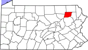 | |
| Townships | ||
| CDPs | ||
| Unincorporated communities | ||
| Ghost town | ||
| ||
| Authority control |
|
|---|