Lamontélarié
Lamontélarié is a commune in the Tarn department in southern France.
Lamontélarié | |
|---|---|
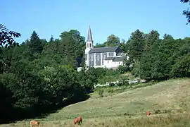 The church and surroundings in Lamontélarié | |
Location of Lamontélarié 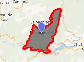
| |
 Lamontélarié  Lamontélarié | |
| Coordinates: 43°37′29″N 2°36′11″E | |
| Country | France |
| Region | Occitanie |
| Department | Tarn |
| Arrondissement | Castres |
| Canton | Les Hautes Terres d'Oc |
| Intercommunality | Montagne du Haut Languedoc |
| Government | |
| • Mayor (2008–2014) | Pierre Escande |
| Area 1 | 21.58 km2 (8.33 sq mi) |
| Population (2017-01-01)[1] | 68 |
| • Density | 3.2/km2 (8.2/sq mi) |
| Time zone | UTC+01:00 (CET) |
| • Summer (DST) | UTC+02:00 (CEST) |
| INSEE/Postal code | 81134 /81260 |
| Elevation | 600–1,111 m (1,969–3,645 ft) (avg. 830 m or 2,720 ft) |
| 1 French Land Register data, which excludes lakes, ponds, glaciers > 1 km2 (0.386 sq mi or 247 acres) and river estuaries. | |
Geography
Lamontélarié is located at the limits of Hérault on the Monts de Lacaune. It is part of the Haut-Languedoc Regional Nature Park. It is about 1 hour and 35 minutes from Albi Castres.
See also
References
| Wikimedia Commons has media related to Lamontélarié. |
- "Populations légales 2017". INSEE. Retrieved 6 January 2020.
| Authority control |
|---|
This article is issued from Wikipedia. The text is licensed under Creative Commons - Attribution - Sharealike. Additional terms may apply for the media files.