Vaour
Vaour (Vaur in Occitan) is a commune and cantonal administrative centre located in the northwestern part of the Tarn department in southern France.
Vaour | |
|---|---|
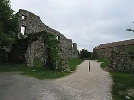 The former Commandry of Vaour | |
.svg.png.webp) Coat of arms | |
Location of Vaour 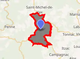
| |
 Vaour  Vaour | |
| Coordinates: 44°04′23″N 1°48′09″E | |
| Country | France |
| Region | Occitanie |
| Department | Tarn |
| Arrondissement | Albi |
| Canton | Carmaux-2 Vallée du Cérou |
| Government | |
| • Mayor (2008–2014) | Georges Bousquet |
| Area 1 | 14.12 km2 (5.45 sq mi) |
| Population (2017-01-01)[1] | 317 |
| • Density | 22/km2 (58/sq mi) |
| Time zone | UTC+01:00 (CET) |
| • Summer (DST) | UTC+02:00 (CEST) |
| INSEE/Postal code | 81309 /81140 |
| Elevation | 240–507 m (787–1,663 ft) (avg. 432 m or 1,417 ft) |
| 1 French Land Register data, which excludes lakes, ponds, glaciers > 1 km2 (0.386 sq mi or 247 acres) and river estuaries. | |
On the north the commune borders the Tarn and Garonne department, and the rising land consists of a gray limestone causse stretching almost to the Averyon river seven or eight kilometers away. Below the commune to the south the landscape consists of the forest of Grésigne - the largest oak forest in the midi - its hills scattered with grassy meadows, and the vineyards of Gaillac.
Vaour contains the ruins of a Templar Commanderie which overlooks the village of Vaour and has commanding views to the South West towards the Pyrenees. The commune also hosts a performing arts festival each summer known as the Eté de Vaour which attracts visitors and performers from across France and further afield. The village hosts a market for good local produce each Thursday in the village square.
References
- "Populations légales 2017". INSEE. Retrieved 6 January 2020.
| Wikimedia Commons has media related to Vaour. |
| Authority control |
|
|---|