Landhi Town
Landhi Town (Urdu: لانڈھی ٹاؤن) was a Karachi borough in the eastern part of the city that was named after the locality of Landhi. Landhi Town was formed in 2001 as part of The Local Government Ordinance 2001, and was subdivided into 9 union councils. The town system was disbanded in 2011,[1] and Korangi Town was re-organized as part of Karachi East District, before Korangi District was formed.
Landhi Town لانڈھی ٹاؤن | |
|---|---|
 Union councils of Landhi Town | |
| Coordinates: 24.8504°N 67.1999°E | |
| Country | Pakistan |
| Province | Sindh |
| City District | Karachi |
| Established | 14 August 2001 |
| Disbanded | 2011 |
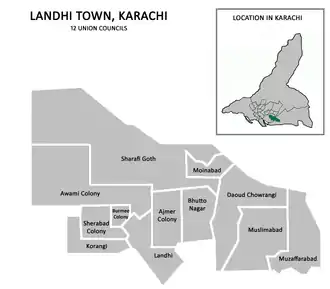
| Union Councils | Awami Colony, Bhutto Nagar, Burmee Colony, Dawood Chowrangi, Khawaja Ajmeer Colony, Korangi, Landhi, Moinabad, Muslimabad, Muzafarabad, Sharafi Goth, Sherabad |
| Government | |
| • Type | Town Council |
| • Town Nazim | Syed Asif Husnain |
| • Naib Nazim | Dr. Irshad Ahmed |
| • Municipal Officer | Noman Arshad |
| Population (1998) | |
| • Total | 666,748 |
| Website | Landhi Town Page |
Location
It is bordered by the Faisal Cantonment and Shah Faisal Town to the north across the Malir River, Bin Qasim Town to the south and east, and Korangi Town to the west. The population of Landhi Town was estimated to be over 660,000 at the 1998 census, of which 99% are Muslim. Sindhis and Pashtuns constitute an overwhelming majority of the population, followed by Muhajirs and Baloch.
History
Landhi Town contained much of the oldest parts of Karachi. The federal government under Pervez Musharraf, who seized power in a 1999 coup d'état, introduced local government reforms in the year 2000, which eliminated the previous "third tier of government" (administrative divisions) and replaced it with the fourth tier (districts). The effect in Karachi was the dissolution of the former Karachi Division, and the merging of its five districts to form a new Karachi City-District with eighteen autonomous constituent towns including Landhi Town. In 2011, the system was disbanded but remained in place for bureaucratic administration until 2015, when the Karachi Metropolitan Corporation system was reintroduced. In 2015, Landhi Town was re-organized as part of Karachi East, before it was made part of Korangi District.
Neighbourhoods
- Awami Colony
- Bhutto Nagar is named after former Prime Minister Zulfikar Ali Bhutto, a Sindhi.
- Sher Pao Colony
- Dawood Chowrangi
- Khawaja Ajmeer Colony is named after Khwaja Moinuddin Chishti of Ajmer.
- Burmee Colony is named for the Rohingya refugees who hail from Myanmar (formerly Burma).
- Korangi lies on the eastern side of Karachi between Karachi and Keti Bandar – the area extending from Korangi to Rehri Creek.
- Landhi is home to Babar Market, one of Asia's largest open air markets. Landhi railway station is also located in this area.
- Moinabad
- Muslimabad
- Majeed Colony
- Muzafarabad
- Sharafi Goth
- Sherabad
References
- Abbasi, Saeed (10 July 2011). "Karachi's district status restored, notification issued". The News Tribe. Retrieved 16 April 2020.
