Le Roy, Iowa
Le Roy is a city in Decatur County, Iowa, United States. The population was 15 in the 2010 census, an increase from 13 in 2000.[4][5]
Le Roy, Iowa | |
|---|---|
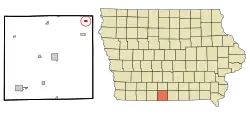 Location of Le Roy, Iowa | |
| Coordinates: 40°52′39″N 93°35′35″W | |
| Country | |
| State | |
| County | Decatur |
| Government | |
| • Mayor | Emett Joy |
| Area | |
| • Total | 0.33 sq mi (0.85 km2) |
| • Land | 0.33 sq mi (0.85 km2) |
| • Water | 0.00 sq mi (0.00 km2) |
| Elevation | 1,115 ft (340 m) |
| Population | |
| • Total | 15 |
| • Estimate (2019)[3] | 14 |
| • Density | 42.42/sq mi (16.40/km2) |
| Time zone | UTC-6 (Central (CST)) |
| • Summer (DST) | UTC-5 (CDT) |
| FIPS code | 19-44580 |
| GNIS feature ID | 0458257 |
In the 2000 census, Le Roy had the distinction of being the second smallest populated incorporated city in Iowa. With the increase in the 2010 census of both Le Roy and Beaconsfield (population 11 in 2000), they now share the title of being the smallest populated incorporated cities in Iowa.
History
Le Roy got its start in 1880, following construction of the Humeston and Shenandoah Railroad through the territory.[6] The city is named for Leroy Buffman, an early settler.[7]
Geography
Le Roy's longitude and latitude are 40.877538, -93.593002.[8]
According to the United States Census Bureau, the city has a total area of 0.33 square miles (0.85 km2), all land.[9]
Demographics
| Historical population | |||
|---|---|---|---|
| Census | Pop. | %± | |
| 1910 | 185 | — | |
| 1920 | 174 | −5.9% | |
| 1930 | 142 | −18.4% | |
| 1940 | 129 | −9.2% | |
| 1950 | 91 | −29.5% | |
| 1960 | 70 | −23.1% | |
| 1970 | 43 | −38.6% | |
| 1980 | 31 | −27.9% | |
| 1990 | 34 | 9.7% | |
| 2000 | 13 | −61.8% | |
| 2010 | 15 | 15.4% | |
| 2019 (est.) | 14 | [3] | −6.7% |
| U.S. Decennial Census[10] | |||
2010 census
As of the census[2] of 2010, there were 15 people, 8 households, and 3 families residing in the city. The population density was 45.5 inhabitants per square mile (17.6/km2). There were 9 housing units at an average density of 27.3 per square mile (10.5/km2). The racial makeup of the city was 93.3% White and 6.7% from two or more races.
There were 8 households, of which 12.5% had children under the age of 18 living with them, 12.5% were married couples living together, 25.0% had a male householder with no wife present, and 62.5% were non-families. 50.0% of all households were made up of individuals, and 12.5% had someone living alone who was 65 years of age or older. The average household size was 1.88 and the average family size was 2.33.
The median age in the city was 56.3 years. 13.3% of residents were under the age of 18; 0.1% were between the ages of 18 and 24; 26.7% were from 25 to 44; 40% were from 45 to 64; and 20% were 65 years of age or older. The gender makeup of the city was 40.0% male and 60.0% female.
2000 census
As of the census[11] of 2000, there were 13 people, 6 households, and 4 families residing in the city. The population density was 39.4 people per square mile (15.2/km2). There were 15 housing units at an average density of 45.5 per square mile (17.6/km2). The racial makeup of the city was 100.00% White.
There were 6 households, out of which 50.0% had children under the age of 18 living with them, 50.0% were married couples living together, 33.3% had a female householder with no husband present, and 16.7% were non-families. 16.7% of all households were made up of individuals, and none had someone living alone who was 65 years of age or older. The average household size was 2.17 and the average family size was 2.40.
In the city, the population was spread out, with 23.1% under the age of 18, 7.7% from 18 to 24, 53.8% from 45 to 64, and 15.4% who were 65 years of age or older. The median age was 50 years. For every 100 females, there were 62.5 males. For every 100 females age 18 and over, there were 66.7 males.
The median income for a household in the city was $33,125, and the median income for a family was $34,375. Males had a median income of $31,250 versus $0 for females. The per capita income for the city was $14,560. None of the population or families were below the poverty line.
Education
Mormon Trail Community School District operates schools serving the community.[12]
References
- "2019 U.S. Gazetteer Files". United States Census Bureau. Retrieved July 17, 2020.
- "U.S. Census website". United States Census Bureau. Retrieved 2012-05-11.
- "Population and Housing Unit Estimates". United States Census Bureau. May 24, 2020. Retrieved May 27, 2020.
- "Population & Housing Occupancy Status 2010". United States Census Bureau American FactFinder. Retrieved May 6, 2011.
- "Data from the 2010 Census". State Data Center of Iowa. Archived from the original on July 18, 2011. Retrieved May 6, 2011.
- Smith, Heman Conoman (1915). History of Decatur County, Iowa, and Its People, Volume 1. S. J. Clarke Publishing Company. p. 180.
- Savage, Tom (Aug 1, 2007). A Dictionary of Iowa Place-Names. University of Iowa Press. p. 129. ISBN 9781587297595.
- "US Gazetteer files: 2010, 2000, and 1990". United States Census Bureau. 2011-02-12. Retrieved 2011-04-23.
- "US Gazetteer files 2010". United States Census Bureau. Archived from the original on 2012-01-25. Retrieved 2012-05-11.
- "Census of Population and Housing". Census.gov. Retrieved June 4, 2015.
- "U.S. Census website". United States Census Bureau. Retrieved 2008-01-31.
- "Mormon Trail." Iowa Department of Education. Retrieved on June 19, 2018.
External links
| Wikimedia Commons has media related to Le Roy, Iowa. |
- City-Data - comprehensive statistical data and more about Le Roy
Municipalities and communities of Decatur County, Iowa, United States | ||
|---|---|---|
| Cities | Map of Iowa highlighting Decatur County | |
| Townships | ||
| Unincorporated communities | ||
| ||
| Authority control |
|---|