Decatur County, Iowa
Decatur County (/dɪˈkeɪtər/) is a county located in the U.S. state of Iowa. As of the 2010 census, the population was 8,457.[1] The county seat is Leon.[2] This county is named for Stephen Decatur, Jr., a hero in the War of 1812.[3]
Decatur County | |
|---|---|
 | |
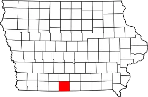 Location within the U.S. state of Iowa | |
 Iowa's location within the U.S. | |
| Coordinates: 40°44′29″N 93°46′51″W | |
| Country | |
| State | |
| Founded | 1846 |
| Named for | Stephen Decatur, Jr. |
| Seat | Leon |
| Largest city | Lamoni |
| Area | |
| • Total | 533 sq mi (1,380 km2) |
| • Land | 532 sq mi (1,380 km2) |
| • Water | 1.6 sq mi (4 km2) 0.3% |
| Population (2010) | |
| • Total | 8,457 |
| • Estimate (2018) | 7,890 |
| • Density | 16/sq mi (6.1/km2) |
| Time zone | UTC−6 (Central) |
| • Summer (DST) | UTC−5 (CDT) |
| Congressional district | 2nd |
| Website | www |
History
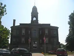
Decatur County was organized in 1850 and named for Stephen Decatur, a naval hero of the War of 1812. The current courthouse was dedicated in 1908. [4]
Geography
According to the U.S. Census Bureau, the county has a total area of 533 square miles (1,380 km2), of which 532 square miles (1,380 km2) is land and 1.6 square miles (4.1 km2) (0.3%) is water.[5]
Major highways
 Interstate 35
 U.S. Route 69
 Iowa Highway 2
Adjacent counties
- Clarke County (north)
- Wayne County (east)
- Mercer County, Missouri (southeast)
- Harrison County, Missouri (southwest)
- Ringgold County (west)
Demographics
| Historical population | |||
|---|---|---|---|
| Census | Pop. | %± | |
| 1850 | 965 | — | |
| 1860 | 8,677 | 799.2% | |
| 1870 | 12,018 | 38.5% | |
| 1880 | 15,336 | 27.6% | |
| 1890 | 15,643 | 2.0% | |
| 1900 | 18,115 | 15.8% | |
| 1910 | 16,347 | −9.8% | |
| 1920 | 16,566 | 1.3% | |
| 1930 | 14,903 | −10.0% | |
| 1940 | 14,012 | −6.0% | |
| 1950 | 12,601 | −10.1% | |
| 1960 | 10,539 | −16.4% | |
| 1970 | 9,737 | −7.6% | |
| 1980 | 9,794 | 0.6% | |
| 1990 | 8,338 | −14.9% | |
| 2000 | 8,689 | 4.2% | |
| 2010 | 8,457 | −2.7% | |
| 2018 (est.) | 7,890 | [6] | −6.7% |
| U.S. Decennial Census[7] 1790-1960[8] 1900-1990[9] 1990-2000[10] 2010-2018[1] | |||
2010 census
The 2010 census recorded a population of 8,457 in the county, with a population density of 15.897/sq mi (6.138/km2). There were 3,834 housing units, of which 3,223 were occupied.[11]
2000 census
At the 2000 census,[12] there were 8,689 people, 3,337 households and 2,149 families residing in the county. The population density was 16 per square mile (6/km2). There were 3,833 housing units at an average density of 7 per square mile (3/km2). The racial makeup of the county was 96.46% White, 0.98% Black or African American, 0.24% Native American, 0.63% Asian, 0.12% Pacific Islander, 0.46% from other races, and 1.12% from two or more races. 1.70% of the population were Hispanic or Latino of any race.
There were 3,337 households, of which 28.00% had children under the age of 18 living with them, 54.30% were married couples living together, 7.20% had a female householder with no husband present, and 35.60% were non-families. 30.30% of all households were made up of individuals, and 15.50% had someone living alone who was 65 years of age or older. The average household size was 2.37 and the average family size was 2.96.
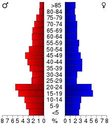
23.00% of the population were under the age of 18, 16.30% from 18 to 24, 21.60% from 25 to 44, 21.50% from 45 to 64, and 17.70% who were 65 years of age or older. The median age was 36 years. For every 100 females there were 95.70 males. For every 100 females age 18 and over, there were 91.90 males.
The median household income was $27,343 and the median family income was $34,831. Males had a median income of $25,569 compared with $19,309 for females. The per capita income for the county was $14,209. About 10.90% of families and 15.50% of the population were below the poverty line, including 15.60% of those under age 18 and 13.70% of those age 65 or over.
Decatur County is considered to be the poorest in Iowa, reporting that almost 20% of its residents live in poverty.[13]
County Officials
Supervisors
Bob Bell
Dan Christiansen
Jimmy Fulton
Treasurer
Kathy Martin
Attorney
Lisa Hynden-Jeanes
Auditor
Stephanie Daughton
Recorder
Gale Norman
Sheriff
Ben Boswell
Assesor
Justin Cornett
Engineer
Vacant
Clerk of Court
Traci Tharp
Public Health Administrator
Shelley Bickel
Veterans Affairs Administrator
Samantha Schaff
Conservation Director
Rich Erke
Mental Health Director
Kathy Lerma
Communities
Cities
Townships
Decatur County is divided into these townships:
Population ranking
The population ranking of the following table is based on the 2010 census of Decatur County.[14]
† county seat
| Rank | City/Town/etc. | Municipal type | Population (2010 Census) |
|---|---|---|---|
| 1 | Lamoni | City | 2,324 |
| 2 | † Leon | City | 1,977 |
| 3 | Grand River | City | 236 |
| 4 | Van Wert | City | 230 |
| 5 | Garden Grove | City | 211 |
| 6 | Davis City | City | 204 |
| 7 | Decatur City | City | 197 |
| 8 | Weldon (partially in Clarke County) | City | 125 |
| 9 | Pleasanton | City | 49 |
| 10 | Le Roy | City | 15 |
Politics
| Year | Republican | Democratic | Third Parties |
|---|---|---|---|
| 2016 | 61.5% 2,296 | 32.2% 1,201 | 6.3% 237 |
| 2012 | 50.8% 1,947 | 46.7% 1,791 | 2.5% 95 |
| 2008 | 49.2% 2,020 | 48.4% 1,986 | 2.4% 100 |
| 2004 | 52.1% 2,088 | 46.4% 1,859 | 1.6% 64 |
| 2000 | 51.3% 1,903 | 45.1% 1,674 | 3.6% 132 |
| 1996 | 35.5% 1,287 | 51.0% 1,846 | 13.5% 490 |
| 1992 | 33.0% 1,316 | 46.8% 1,866 | 20.2% 804 |
| 1988 | 38.8% 1,406 | 60.4% 2,192 | 0.8% 29 |
| 1984 | 49.6% 2,104 | 49.5% 2,098 | 0.9% 40 |
| 1980 | 47.7% 2,212 | 44.1% 2,048 | 8.2% 380 |
| 1976 | 41.1% 1,932 | 57.3% 2,698 | 1.6% 77 |
| 1972 | 57.4% 2,638 | 40.9% 1,880 | 1.6% 75 |
| 1968 | 49.3% 2,261 | 44.8% 2,057 | 5.9% 270 |
| 1964 | 31.6% 1,542 | 68.2% 3,331 | 0.3% 12 |
| 1960 | 55.7% 3,039 | 44.2% 2,411 | 0.1% 7 |
| 1956 | 50.9% 2,912 | 49.0% 2,806 | 0.1% 7 |
| 1952 | 58.7% 3,621 | 40.9% 2,521 | 0.4% 26 |
| 1948 | 43.9% 2,547 | 54.7% 3,172 | 1.5% 84 |
| 1944 | 46.8% 2,934 | 52.9% 3,316 | 0.3% 18 |
| 1940 | 46.9% 3,494 | 52.9% 3,938 | 0.2% 16 |
| 1936 | 44.4% 3,327 | 55.1% 4,131 | 0.5% 36 |
| 1932 | 36.8% 2,148 | 61.6% 3,591 | 1.6% 91 |
| 1928 | 59.1% 3,942 | 40.1% 2,675 | 0.9% 58 |
| 1924 | 47.1% 3,221 | 24.8% 1,693 | 28.1% 1,921 |
| 1920 | 61.2% 4,187 | 37.9% 2,592 | 1.0% 66 |
| 1916 | 47.5% 1,962 | 51.1% 2,111 | 1.5% 62 |
| 1912 | 34.4% 1,351 | 42.2% 1,659 | 23.4% 918 |
| 1908 | 52.5% 2,149 | 44.2% 1,809 | 3.3% 133 |
| 1904 | 58.4% 2,430 | 37.2% 1,548 | 4.3% 180 |
| 1900 | 53.2% 2,415 | 45.3% 2,058 | 1.5% 66 |
| 1896 | 48.5% 2,268 | 50.5% 2,362 | 1.1% 50 |
See also
References
- "State & County QuickFacts". United States Census Bureau. Archived from the original on June 7, 2011. Retrieved July 16, 2014.
- "Find a County". National Association of Counties. Archived from the original on May 31, 2011. Retrieved June 7, 2011.
- Gannett, Henry (1905). The Origin of Certain Place Names in the United States. Govt. Print. Off. p. 102.
- "County History". Dacatur County. Retrieved 2020-07-08.
- "US Gazetteer files: 2010, 2000, and 1990". United States Census Bureau. February 12, 2011. Retrieved April 23, 2011.
- "Population and Housing Unit Estimates". Retrieved June 22, 2019.
- "U.S. Decennial Census". United States Census Bureau. Retrieved July 16, 2014.
- "Historical Census Browser". University of Virginia Library. Retrieved July 16, 2014.
- "Population of Counties by Decennial Census: 1900 to 1990". United States Census Bureau. Retrieved July 16, 2014.
- "Census 2000 PHC-T-4. Ranking Tables for Counties: 1990 and 2000" (PDF). United States Census Bureau. Retrieved July 16, 2014.
- "Population & Housing Occupancy Status 2010". United States Census Bureau American FactFinder. Retrieved May 8, 2011.
- "U.S. Census website". United States Census Bureau. Retrieved 2008-01-31.
- Mike Kilen, "Headline: Who will win in Iowa's poorest county?", Des Moines Register, 6 June 2004 (subscription required)
- "Archived copy". Retrieved February 13, 2016.
- Leip, David. "Dave Leip's Atlas of U.S. Presidential Elections". uselectionatlas.org. Retrieved April 25, 2018.
External links
| Wikimedia Commons has media related to Decatur County, Iowa. |
Places adjacent to Decatur County, Iowa | ||||||||||
|---|---|---|---|---|---|---|---|---|---|---|
| ||||||||||
Municipalities and communities of Decatur County, Iowa, United States | ||
|---|---|---|
| Cities | Map of Iowa highlighting Decatur County | |
| Townships | ||
| Unincorporated communities | ||
| ||

| Authority control |
|---|