Letcher, South Dakota
Letcher is a town in Sanborn County, South Dakota, United States. The population was 173 at the 2010 census.
Letcher, South Dakota | |
|---|---|
| Motto(s): "The Right Place...To Call Home!"[1] | |
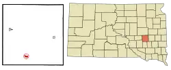 Location in Sanborn County and the state of South Dakota | |
| Coordinates: 43°53′52″N 98°8′22″W | |
| Country | United States |
| State | South Dakota |
| County | Sanborn |
| Settled | 1883[2] |
| Area | |
| • Total | 0.65 sq mi (1.69 km2) |
| • Land | 0.62 sq mi (1.59 km2) |
| • Water | 0.04 sq mi (0.10 km2) |
| Elevation | 1,302 ft (397 m) |
| Population | |
| • Total | 173 |
| • Estimate (2019)[5] | 176 |
| • Density | 285.71/sq mi (110.37/km2) |
| Time zone | UTC-6 (Central (CST)) |
| • Summer (DST) | UTC-5 (CDT) |
| ZIP code | 57359 |
| Area code(s) | 605 |
| FIPS code | 46-36620[6] |
| GNIS feature ID | 1256101[7] |
| Website | http://www.letchersd.com/ |
Letcher has the name of O. T. Letcher, a local landowner.[8]
Geography
Letcher is located at 43°53′52″N 98°8′22″W (43.897780, -98.139366).[9]
According to the United States Census Bureau, the town has a total area of 0.66 square miles (1.71 km2), of which 0.62 square miles (1.61 km2) is land and 0.04 square miles (0.10 km2) is water.[10]
Demographics
| Historical population | |||
|---|---|---|---|
| Census | Pop. | %± | |
| 1900 | 130 | — | |
| 1910 | 402 | 209.2% | |
| 1920 | 454 | 12.9% | |
| 1930 | 414 | −8.8% | |
| 1940 | 344 | −16.9% | |
| 1950 | 291 | −15.4% | |
| 1960 | 296 | 1.7% | |
| 1970 | 201 | −32.1% | |
| 1980 | 221 | 10.0% | |
| 1990 | 164 | −25.8% | |
| 2000 | 177 | 7.9% | |
| 2010 | 173 | −2.3% | |
| 2019 (est.) | 176 | [5] | 1.7% |
| U.S. Decennial Census | |||
2010 census
As of the census[4] of 2010, there were 173 people, 77 households, and 42 families residing in the town. The population density was 279.0 inhabitants per square mile (107.7/km2). There were 83 housing units at an average density of 133.9 per square mile (51.7/km2). The racial makeup of the town was 100.0% White.
There were 77 households, of which 31.2% had children under the age of 18 living with them, 41.6% were married couples living together, 7.8% had a female householder with no husband present, 5.2% had a male householder with no wife present, and 45.5% were non-families. 39.0% of all households were made up of individuals, and 15.6% had someone living alone who was 65 years of age or older. The average household size was 2.25 and the average family size was 3.07.
The median age in the town was 38.6 years. 23.7% of residents were under the age of 18; 8.7% were between the ages of 18 and 24; 25.4% were from 25 to 44; 30% were from 45 to 64; and 12.1% were 65 years of age or older. The gender makeup of the town was 51.4% male and 48.6% female.
2000 census
As of the census[6] of 2000, there were 177 people, 75 households, and 51 families residing in the town. The population density was 291.5 people per square mile (112.0/km2). There were 84 housing units at an average density of 138.4 per square mile (53.2/km2). The racial makeup of the town was 97.74% White, 0.56% Asian, 0.56% Pacific Islander, and 1.13% from two or more races.
There were 75 households, out of which 32.0% had children under the age of 18 living with them, 54.7% were married couples living together, 6.7% had a female householder with no husband present, and 32.0% were non-families. 24.0% of all households were made up of individuals, and 10.7% had someone living alone who was 65 years of age or older. The average household size was 2.36 and the average family size was 2.78.
In the town, the population was spread out, with 24.9% under the age of 18, 9.0% from 18 to 24, 26.6% from 25 to 44, 20.9% from 45 to 64, and 18.6% who were 65 years of age or older. The median age was 40 years. For every 100 females, there were 103.4 males. For every 100 females age 18 and over, there were 101.5 males.
The median income for a household in the town was $27,083, and the median income for a family was $37,083. Males had a median income of $22,917 versus $15,208 for females. The per capita income for the town was $14,164. About 18.6% of families and 24.0% of the population were below the poverty line, including 42.9% of those under the age of eighteen and 10.7% of those 65 or over.
Education
Letcher Public Schools are part of the Sanborn Central School District. The district includes an elementary school, middle school and high school. Students attend Sanborn Central High School.[1][11]
References
- "Letcher South Dakota". Letcher South Dakota. Retrieved September 29, 2012.
- "SD Towns" (PDF). South Dakota State Historical Society. Archived from the original (PDF) on 2010-02-10. Retrieved 2010-02-14.
- "2019 U.S. Gazetteer Files". United States Census Bureau. Retrieved July 30, 2020.
- "U.S. Census website". United States Census Bureau. Retrieved 2012-06-21.
- "Population and Housing Unit Estimates". United States Census Bureau. May 24, 2020. Retrieved May 27, 2020.
- "U.S. Census website". United States Census Bureau. Retrieved 2008-01-31.
- "US Board on Geographic Names". United States Geological Survey. 2007-10-25. Retrieved 2008-01-31.
- Federal Writers' Project (1940). South Dakota place-names, v.1-3. University of South Dakota. p. 48.
- "US Gazetteer files: 2010, 2000, and 1990". United States Census Bureau. 2011-02-12. Retrieved 2011-04-23.
- "US Gazetteer files 2010". United States Census Bureau. Archived from the original on January 12, 2012. Retrieved 2012-06-21.
- "Sanborn Central School District". Sanborn Central School District. Archived from the original on June 19, 2013. Retrieved October 3, 2012.
External links
- Letcher South Dakota Website
- City-Data.com Comprehensive Statistical Data and more about Letcher
- ePodunk: Profile for Letcher, South Dakota, SD
- Sanborn Central School District
Municipalities and communities of Sanborn County, South Dakota, United States | ||
|---|---|---|
| City | 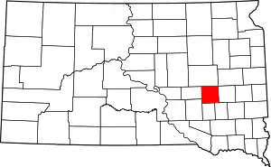 | |
| Towns | ||
| Township | ||
| CDP | ||
| Other unincorporated community | ||
| ||