Lewis, Colorado
Lewis is an unincorporated town, a post office, and a census-designated place (CDP) located in and governed by Montezuma County, Colorado, United States. The Lewis post office has the ZIP Code 81327.[3] At the United States Census 2010, the population of the Lewis CDP was 302, while the population of the 81327 ZIP Code Tabulation Area was 639 including adjacent areas.[4]
Lewis, Colorado | |
|---|---|
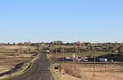 Looking north along U.S. Route 491 in Lewis. | |
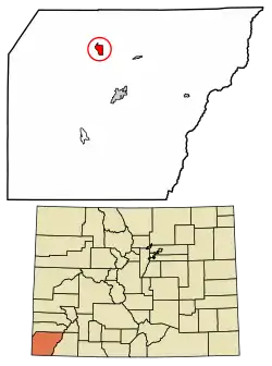 Location of the Lewis CDP in Montezuma County, Colorado. | |
 Lewis Location of the Lewis CDP in the United States. | |
| Coordinates: 37°30′06″N 108°39′36″W[1] | |
| Country | |
| State | |
| County | Montezuma County |
| Government | |
| • Type | unincorporated town |
| Area | |
| • Total | 3.110 sq mi (8.056 km2) |
| • Land | 3.110 sq mi (8.056 km2) |
| • Water | 0.000 sq mi (0.000 km2) |
| Elevation | 6,729 ft (2,051 m) |
| Population (2010) | |
| • Total | 302 |
| • Density | 97/sq mi (37/km2) |
| Time zone | UTC-7 (MST) |
| • Summer (DST) | UTC-6 (MDT) |
| ZIP Code[3] | 81327 |
| Area code(s) | 970 |
| GNIS feature[2] | Lewis CDP |
Geography
The Lewis CDP has an area of 1,991 acres (8.056 km2), all land.[1]
Demographics
The United States Census Bureau initially defined the Lewis CDP for the United States Census 2010.
| Year | Pop. | ±% |
|---|---|---|
| 2010 | 302 | — |
| 2020 | — | |
| Source: United States Census Bureau | ||
See also
- Outline of Colorado
- State of Colorado
- Colorado cities and towns
- Colorado counties
- Old Spanish National Historic Trail
References
- "State of Colorado Census Designated Places - BAS20 - Data as of January 1, 2020". United States Census Bureau. Retrieved December 24, 2020.
- "U.S. Board on Geographic Names: Domestic Names". United States Geological Survey. Retrieved December 24, 2020.
- "Look Up a ZIP Code". United States Postal Service. Retrieved December 24, 2020.
- "2010: DEC Summary File 1". United States Census Bureau. Retrieved December 24, 2020.
External links
Municipalities and communities of Montezuma County, Colorado, United States | ||
|---|---|---|
| City | 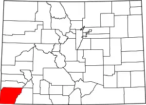 Map of Colorado highlighting Montezuma County | |
| Towns | ||
| CDP | ||
| Unincorporated communities | ||
| Indian reservations | ||
| Footnotes | ‡This populated place also has portions in an adjacent county or counties | |
| ||
This article is issued from Wikipedia. The text is licensed under Creative Commons - Attribution - Sharealike. Additional terms may apply for the media files.