Towaoc, Colorado
Towaoc[5] is an unincorporated town, a post office, a census-designated place (CDP), and the capital of the Ute Mountain Ute Tribe located on the Ute Mountain Ute Reservation in Montezuma County, Colorado, United States. The Towaoc post office has the ZIP Code 81334 (post office boxes).[3] At the United States Census 2010, the population of the Towaoc CDP was 1,087, while the population of the 81334 ZIP Code Tabulation Area was 1,493 including adjacent areas.[6]
Towaoc, Colorado | |
|---|---|
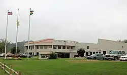 The Ute Mountain Ute Tribal Office Complex in Towaoc. | |
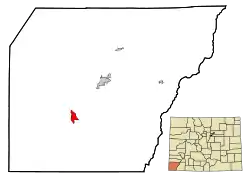 Location of the Towaoc CDP in Montezuma County, Colorado.Colorado | |
 Towaoc Location of the Towaoc CDP in the United States. | |
| Coordinates: 37°12′45″N 108°43′35″W[1] | |
| Country | |
| State | |
| County | Montezuma County |
| Government | |
| • Type | unincorporated town |
| Area | |
| • Total | 3.585 sq mi (9.284 km2) |
| • Land | 3.585 sq mi (9.284 km2) |
| • Water | 0.000 sq mi (0.000 km2) |
| Elevation | 6,007 ft (1,831 m) |
| Population (2010) | |
| • Total | 1,087 |
| • Density | 303/sq mi (117/km2) |
| Time zone | UTC-7 (MST) |
| • Summer (DST) | UTC-6 (MDT) |
| ZIP Code[3] | 81334 |
| Area code(s) | 970 |
| GNIS feature[2] | Towaoc CDP |
Geography
Towaoc is located east of Sleeping Ute Mountain, a sacred mountain of the Ute people, and northeast of the Four Corners Monument.
Old Towaoc, located at the base of Ute Mountain, is approximately 2 miles (3 km) west of US Highways 491-160, and includes various tribal and BIA governmental buildings and housing areas, including the tribal offices of the Ute Mountain Ute Tribe. In recent years, a small complex has been developed directly on US Highway 491-160 at the junction of the road into the original town. This includes the Ute Mountain Casino, Hotel & Resort, with a travel center (convenience store, food service, and fuel sales), campground, and the offices and shops for the Weeminuche Construction Authority (the Tribal construction company) and other facilities.
The Towaoc CDP has an area of 2,294 acres (9.284 km2), all land.[1]
Demographics
The United States Census Bureau initially defined the Towaoc CDP for the 1990 United States Census.
| Year | Pop. | ±% |
|---|---|---|
| 1990 | 700 | — |
| 2000 | 1,097 | +56.7% |
| 2010 | 1,087 | −0.9% |
| 2020 | — | |
| Source: United States Census Bureau | ||
| Languages (2000) [7] | Percent |
|---|---|
| Spoke English at home | 47.18% |
| Spoke Colorado River Numic at home | 45.99% |
| Spoke Navajo at home | 5.31% |
| Spoke Spanish at home | 1.08% |
| Spoke Cheyenne at home | 0.43% |
See also
- Outline of Colorado
- State of Colorado
- Colorado cities and towns
- Colorado counties
- Canyons of the Ancients National Monument
- Mesa Verde National Park, a UNESCO World Heritage Site
- Ute Mountain Ute Tribe
- Yucca House National Monument
Notes
- "State of Colorado Census Designated Places - BAS20 - Data as of January 1, 2020". United States Census Bureau. Retrieved December 24, 2020.
- "U.S. Board on Geographic Names: Domestic Names". United States Geological Survey. Retrieved December 24, 2020.
- "Look Up a ZIP Code". United States Postal Service. Retrieved December 24, 2020.
- Eichler, Geo. R. (1977). Colorado Place Names. Boulder: Johnson Publishing Company. ISBN 978-0-933472-26-6.
- Pronounced /tɔɪɔːk/ (
 listen).[4]
 - "2010: DEC Summary File 1". United States Census Bureau. Retrieved December 24, 2020.
- https://apps.mla.org/cgi-shl/docstudio/docs.pl?map_data_results
External links
- Towaoc @ Colorado.com
- Towaoc @ UncoverColorado.com
- Ute Mountain Ute Tribe website
- Montezuma County website
Municipalities and communities of Montezuma County, Colorado, United States | ||
|---|---|---|
| City | 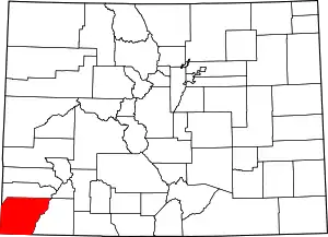 Map of Colorado highlighting Montezuma County | |
| Towns | ||
| CDP | ||
| Unincorporated communities | ||
| Indian reservations | ||
| Footnotes | ‡This populated place also has portions in an adjacent county or counties | |
| ||
| Authority control |
|
|---|