Liberty, Mississippi
Liberty is a town in Amite County, Mississippi. It is part of the McComb, Mississippi Micropolitan Statistical Area. It has a population of 728 according to the 2010 census.[3] It is the county seat of Amite County.[4]
Liberty, Mississippi | |
|---|---|
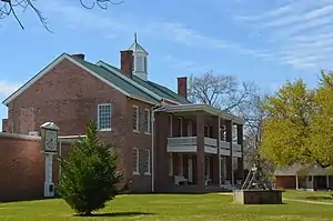 Amite County Courthouse in Liberty | |
 Location of Liberty, Mississippi | |
 Liberty, Mississippi Location in the United States | |
| Coordinates: 31°9′39″N 90°48′14″W | |
| Country | United States |
| State | Mississippi |
| County | Amite |
| Government | |
| • Mayor | Pat Talbert |
| Area | |
| • Total | 2.06 sq mi (5.34 km2) |
| • Land | 2.06 sq mi (5.34 km2) |
| • Water | 0.00 sq mi (0.00 km2) |
| Elevation | 338 ft (103 m) |
| Population (2010) | |
| • Total | 728 |
| • Estimate (2019)[2] | 667 |
| • Density | 323.63/sq mi (124.95/km2) |
| Time zone | UTC-6 (Central (CST)) |
| • Summer (DST) | UTC-5 (CDT) |
| ZIP code | 39645 |
| Area code(s) | 601 |
| FIPS code | 28-40640 |
| GNIS feature ID | 0672435 |
| Website | www |
The town can be accessed via I-55, then west on Mississippi Highway 24. McGehee Air Park is located about a mile west of town.
Liberty celebrates its Heritage Days Festival during the first weekend of each May.
Air Cruisers manufacturing plant is located in Liberty. Owned by Zodiac Aerospace, the plant produces evacuation slides, life rafts, and life vests for the aviation industry.
Eleven sites in or near Liberty are listed on the National Register of Historic Places.
History
Liberty was incorporated on February 24, 1809.
The Amite County Courthouse in Liberty is the oldest in Mississippi. Erected in 1839, the courthouse was enlarged and modernized in 1936.[6] It is listed on the National Register of Historic Places.
The Amite Female Seminary (also known as the 'Little Red Schoolhouse'), built in 1853, was a girls finishing school located in Liberty. During the American Civil War, in the spring of 1863, Federal troops under the command of Colonel Benjamin Grierson, a former music teacher, burned the school, but spared the school's music building. The Federal commander permitted musical instruments to be removed, and was prepared to give the order to torch the building, when he recognized the music school's director, Rev. Milton Shirk, as a former classmate from New York. The two-story, two-room music building survives to this day on Mississippi Highway 569, and is listed on the National Register of Historic Places.[7][8]
Gail Borden, who developed a process in the early 1850s for condensing milk and founded the New York Condensed Milk Company (later known as Borden Inc., lived in Liberty from 1822 to 1829.
Between 1904 and 1921, a branch of the Liberty–White Railroad, a narrow-gauge logging rail line serving the White Lumber Company, ran between McComb, Mississippi and Liberty.[9]
During the Civil Rights Movement, in September 1961, Herbert Lee, an African-American dairy farmer and member of NAACP, was murdered in Liberty at the Westbrook Cotton Gin by E.H. Hurst, a white state legislator. Lee had attended voter registration classes and volunteered to try to register to vote, Witnesses to the killing were intimidated by armed white men in the courtroom to support Hurst's claim of self-defense, and he was released without charges. Louis Allen, a married African-American landowner with a logging business, reported the truth about the crime to federal officials while seeking protection for testimony. He did not get protection. He suffered economic blackmail, arrests and harassment, and was killed in January 1964.
Since 1994, three investigations have suggested that the county sheriff was the perpetrator, but no prosecution was undertaken. Since that period, Amite County has continued to lose population because of its poverty and limited opportunities. It now has a white majority, although the margin is less than in Liberty. The Westbrook Cotton Gin has been listed on the National Register of Historic Places.
Liberty was the location of the fourth-wettest tropical cyclone in Mississippi in 2001; Tropical Storm Allison dropped 18.95 inches (481 mm) of precipitation.
Liberty, Texas is thought to have been named after this town, as numerous families from Amite County moved west in the 1820s to settle in the Atascosito district north-east of Houston.[10]
Geography
According to the United States Census Bureau, the town covers an area of 2.0 square miles (5.3 km2), of which 0.00077 square miles (0.002 km2), or 0.03%, is water.[3]
Demographics
| Historical population | |||
|---|---|---|---|
| Census | Pop. | %± | |
| 1900 | 392 | — | |
| 1910 | 556 | 41.8% | |
| 1920 | 515 | −7.4% | |
| 1930 | 551 | 7.0% | |
| 1940 | 665 | 20.7% | |
| 1950 | 683 | 2.7% | |
| 1960 | 642 | −6.0% | |
| 1970 | 612 | −4.7% | |
| 1980 | 669 | 9.3% | |
| 1990 | 624 | −6.7% | |
| 2000 | 633 | 1.4% | |
| 2010 | 728 | 15.0% | |
| 2019 (est.) | 667 | [2] | −8.4% |
| U.S. Decennial Census[11] | |||
As of the census[12] of 2000, there were 633 people, 263 households, and 170 families residing in the town. The population density was 307.6 people per square mile (118.6/km2). There were 309 housing units at an average density of 150.1 per square mile (57.9/km2). The racial makeup of the town was 74.25% White, 24.17% African American, 1.11% from other races, and 0.47% from two or more races. Hispanic or Latino of any race were 1.90% of the population.
There were 263 households, out of which 25.5% had children under the age of 18 living with them, 50.2% were married couples living together, 13.3% had a female householder with no husband present, and 35.0% were non-families. 33.5% of all households were made up of individuals, and 19.4% had someone living alone who was 65 years of age or older. The average household size was 2.32 and the average family size was 2.96.
In the town, the population was spread out, with 24.0% under the age of 18, 10.3% from 18 to 24, 23.4% from 25 to 44, 22.0% from 45 to 64, and 20.4% who were 65 years of age or older. The median age was 37 years. For every 100 females, there were 93.6 males. For every 100 females age 18 and over, there were 87.9 males.
The median income for a household in the town was $23,882, and the median income for a family was $35,179. Males had a median income of $38,000 versus $16,944 for females. The per capita income for the town was $13,062. About 19.5% of families and 21.5% of the population were below the poverty line, including 19.7% of those under age 18 and 25.4% of those age 65 or over.
Education
The town of Liberty is served by the Amite County School District. Liberty is also the home of Amite School Center, a K-12 education institution that is a member of the Mississippi Association of Independent Schools. The town manages a state property named the Ethel Stratton Vance Natural Area, just west of town, which is often used for educational purposes and is home to sports fields, camping areas, a large equestrian center, and over 200 acres of biologically diverse ravines, beaver impoundments, and bottomland hardwood forest along the West Fork Amite River.[13]
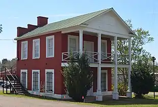 Amite Female Seminary, commonly known as the "Little Red Schoolhouse," established in 1853 and spared during the Civil War
 Liberty (Rexall) Drug Store, Main Street
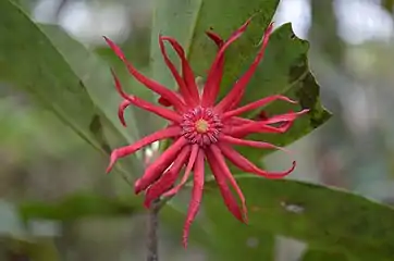 Illicium floridanum, Florida anise or stinkbush, a plant species endemic to the southeastern U.S.,[14] common at the Vance Natural Area
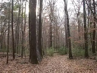 Bottomland mixed hardwood-spruce pine forest along the West Fork Amite River
 Stewartia malacodendron, or silky camellia, an uncommon species of the southeastern U.S.,[15] found at the Vance Natural Area
Notable people
- Casey Aldridge, Jamie Lynn Spears' ex-fiancé & father of their daughter, Maddie.
- Louis Allen, murdered property owner and logger
- T. F. Badon, member of the Mississippi House of Representatives from 1952 to 1956[16]
- L. C. Bates, African-American civil rights activist and the husband of Daisy Bates.
- James Brown, former American football offensive lineman[17]
- Will D. Campbell, minister, author, and civil rights activist.
- Jerry Clower, country comedian.
- E. H. Hurst, member of the Mississippi House of Representatives.
- Gabe Jackson, American football player for the Oakland Raiders of the National Football League (NFL).
- Darrah Johnson, Survivor Pearl Islands player, was born and raised in Liberty
- Herbert Lee, civil rights activist.
- William F. Love, U.S. Representative from Mississippi.
- Glenn Moore, softball coach.
- Clyde V. Ratcliff, member of the Louisiana Senate from 1944 to 1948, was born in Liberty in 1879.[18]
- Andy Rodgers, (March 14, 1922 – August 14, 2004) was a Delta blues harmonicist, guitarist, singer and songwriter born nearby Liberty in 1922.[19]
- George H. Tichenor, inventor of an antiseptic, briefly lived and married in Liberty[20]
References
- "2019 U.S. Gazetteer Files". United States Census Bureau. Retrieved July 26, 2020.
- "Population and Housing Unit Estimates". United States Census Bureau. May 24, 2020. Retrieved May 27, 2020.
- "Geographic Identifiers: 2010 Demographic Profile Data (G001): Liberty town, Mississippi". U.S. Census Bureau, American Factfinder. Archived from the original on February 12, 2020. Retrieved June 19, 2013.
- "Find a County". National Association of Counties. Archived from the original on May 31, 2011. Retrieved 2011-06-07.
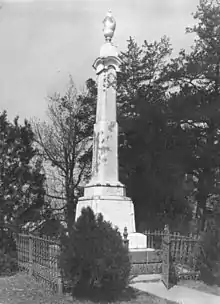
- Taylor, Dawn (August 31, 2014). "Confederate Monument, Liberty, MS". The Battle of Liberty, MS. Archived from the original on February 17, 2017. Retrieved February 16, 2017.
- "Amite Repairs Court House". Woodville Republican. May 2, 1936.
- Anders, Billy (Jan 25, 2008). "Give me Liberty, or Give Me...Cloudcroft!!!". Southern Herald.
- "National Register of Historic Places Inventory Nomination Form" (PDF). U.S. Dept. of the Interior. 1980.
- McElvaine, Robert S. (1988). Mississippi: The WPA Guide to the Magnolia State. University Press of Mississippi.
- Schaadt, Robert L. (July 13, 2011). "Texas History ~ Founders of Liberty: Hugh Blair Johnston". The Vindicator.
- "Census of Population and Housing". Census.gov. Retrieved June 4, 2015.
- "U.S. Census website". United States Census Bureau. Retrieved 2008-01-31.
- "Ethel Stratton Vance Natural Area". Amite County, Mississippi. Retrieved 17 March 2018.
- "USDA PLANTS database". U.S. Department of Agriculture. Retrieved 17 March 2018.
- "USDA PLANTS database". U.S. Department of Agriculture. Retrieved 17 March 2018.
- "T.F. Badon, a Server and Friend Dies at 92" (PDF). The Southern Herald. May 28, 2015. pp. 1, 8. Retrieved 18 May 2020.
- "James Brown". ESPN. Retrieved 18 May 2020.
- Obituary of Clyde V. Ratcliff, Sr., Tensas Gazette, October 8, 1952
- Lee, Ching (2004-08-18). "Legendary Mid-Valley blues man dies at 82 - Appeal-Democrat: Home". Appeal-Democrat.com. Retrieved 2016-10-27.
- Huff, Robert Glen; Nunnery, Hattie Pearl (2009). Amite County & Liberty, Mississippi: Celebrating 200 Years. Virginia Beach, VA: Donning Company Publishers. ISBN 978-1-57864-547-3.
External links
Municipalities and communities of Amite County, Mississippi, United States | ||
|---|---|---|
| Towns | 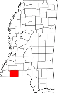 Map of Mississippi highlighting Amite County | |
| Unincorporated communities | ||
| Ghost town | ||
| Footnotes | ‡This populated place also has portions in an adjacent county or counties | |
| ||
| Authority control |
|---|