Linapacan
Linapacan, officially the Municipality of Linapacan (Tagalog: Bayan ng Linapacan), is a 5th class municipality in the province of Palawan, Philippines. According to the 2015 census, it has a population of 15,668 people. [3]
Linapacan | |
|---|---|
| Municipality of Linapacan | |
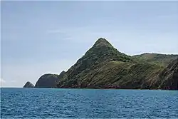 Dicabaito Island | |
 Seal | |
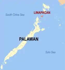 Map of Palawan with Linapacan highlighted | |
OpenStreetMap 
| |
.svg.png.webp) Linapacan Location within the Philippines | |
| Coordinates: 11°30′N 119°52′E | |
| Country | |
| Region | Mimaropa (Region IV-B) |
| Province | Palawan |
| District | 1st district |
| Founded | 1954 |
| Barangays | 10 (see Barangays) |
| Government | |
| • Type | Sangguniang Bayan |
| • Mayor | Jessie F. Del Prado |
| • Vice Mayor | Ruin Q. Abin |
| • Representative | Franz Josef George E. Alvarez |
| • Electorate | 9,689 voters (2019) |
| Area | |
| • Total | 195.44 km2 (75.46 sq mi) |
| Elevation | 22 m (72 ft) |
| Highest elevation | 255 m (837 ft) |
| Lowest elevation | 0 m (0 ft) |
| Population | |
| • Total | 15,668 |
| • Density | 80/km2 (210/sq mi) |
| • Households | 3,359 |
| Economy | |
| • Income class | 5th municipal income class |
| • Poverty incidence | 37.74% (2015)[4] |
| • Revenue | ₱53,284,821.04 (2016) |
| Service provider | |
| • Electricity | Busuanga Island Electric Cooperative |
| Time zone | UTC+8 (PST) |
| ZIP code | 5314 |
| PSGC | |
| IDD : area code | +63 (0)48 |
| Climate type | tropical climate |
| Native languages | Palawano Tagalog |
History
When the Spaniards came in the 16th century, they made a fortress called Caseledan Port and Eli Port to be able to protect against Moro raiders.
In 1954, the 10 islands of Barangonan, Cabunlawan, Calibangbangan, Decabaitot, Maroyogroyog, Nangalao, New Calaylayan, Pical, San Miguel, and San Nicolas were separated from Coron to form the town of Linapacan.[5] The municipality of Culion is between Linapacan and Coron.
In October 2013, the website Daily News Dig proclaimed the waters of Linapacan Island so clear that the website put it on the top of their list of 35 waters to swim in around the world before one dies.[6]
Barangays
Linapacan is politically subdivided into 10 island barangays.
- Barangonan (Iloc)
- Cabunlawan
- Calibangbangan
- Decabaitot
- Maroyogroyog
- Nangalao
- New Culaylayan
- Pical
- San Miguel (Poblacion)
- San Nicolas
Demographics
|
| ||||||||||||||||||||||||||||||||||||
| Source: Philippine Statistics Authority [3] [7] [8][9] | |||||||||||||||||||||||||||||||||||||
In the 2015 census, the population of Linapacan was 15,668 people, [3] with a density of 80 inhabitants per square kilometre or 210 inhabitants per square mile.
Climate
| Climate data for Linapacan, Palawan | |||||||||||||
|---|---|---|---|---|---|---|---|---|---|---|---|---|---|
| Month | Jan | Feb | Mar | Apr | May | Jun | Jul | Aug | Sep | Oct | Nov | Dec | Year |
| Average high °C (°F) | 28 (82) |
29 (84) |
29 (84) |
31 (88) |
30 (86) |
29 (84) |
29 (84) |
29 (84) |
29 (84) |
29 (84) |
29 (84) |
28 (82) |
29 (84) |
| Average low °C (°F) | 22 (72) |
22 (72) |
22 (72) |
23 (73) |
24 (75) |
24 (75) |
24 (75) |
24 (75) |
24 (75) |
24 (75) |
23 (73) |
23 (73) |
23 (74) |
| Average precipitation mm (inches) | 45 (1.8) |
34 (1.3) |
62 (2.4) |
64 (2.5) |
127 (5.0) |
159 (6.3) |
172 (6.8) |
147 (5.8) |
167 (6.6) |
182 (7.2) |
172 (6.8) |
88 (3.5) |
1,419 (56) |
| Average rainy days | 12.1 | 9.4 | 13.0 | 14.3 | 22.7 | 26.9 | 28.0 | 26.4 | 27.0 | 27.0 | 22.7 | 17.8 | 247.3 |
| Source: Meteoblue [10] | |||||||||||||
Economy
| Poverty Incidence of Linapacan | |
| Source: Philippine Statistics Authority[11][12][13][14][15][16] | |
See also
References
- Municipality of Linapacan | (DILG)
- "Province: Palawan". PSGC Interactive. Quezon City, Philippines: Philippine Statistics Authority. Retrieved 12 November 2016.
- Census of Population (2015). "Region IV-B (Mimaropa)". Total Population by Province, City, Municipality and Barangay. PSA. Retrieved 20 June 2016.
- https://psa.gov.ph/sites/default/files/City%20and%20Municipal-level%20Small%20Area%20Poverty%20Estimates_%202009%2C%202012%20and%202015_0.xlsx; publication date: 10 July 2019; publisher: Philippine Statistics Authority.
- "An Act to Create the Municipality of Linapacan in the Province of Palawan". LawPH.com. Retrieved 2011-04-11.
- http://dailynewsdig.com/35-clearest-waters-world-swim-die/
- Census of Population and Housing (2010). "Region IV-B (Mimaropa)". Total Population by Province, City, Municipality and Barangay. NSO. Retrieved 29 June 2016.
- Censuses of Population (1903–2007). "Region IV-B (Mimaropa)". Table 1. Population Enumerated in Various Censuses by Province/Highly Urbanized City: 1903 to 2007. NSO.
- "Province of Palawan". Municipality Population Data. Local Water Utilities Administration Research Division. Retrieved 17 December 2016.
- "Linapacan: Average Temperatures and Rainfall". Meteoblue. Retrieved 17 November 2019.
- "Poverty incidence (PI):". Philippine Statistics Authority. Retrieved 28 December 2020.
- https://psa.gov.ph/sites/default/files/NSCB_LocalPovertyPhilippines_0.pdf; publication date: 29 November 2005; publisher: Philippine Statistics Authority.
- https://psa.gov.ph/sites/default/files/2003%20SAE%20of%20poverty%20%28Full%20Report%29_1.pdf; publication date: 23 March 2009; publisher: Philippine Statistics Authority.
- https://psa.gov.ph/sites/default/files/2006%20and%202009%20City%20and%20Municipal%20Level%20Poverty%20Estimates_0_1.pdf; publication date: 3 August 2012; publisher: Philippine Statistics Authority.
- https://psa.gov.ph/sites/default/files/2012%20Municipal%20and%20City%20Level%20Poverty%20Estima7tes%20Publication%20%281%29.pdf; publication date: 31 May 2016; publisher: Philippine Statistics Authority.
- https://psa.gov.ph/sites/default/files/City%20and%20Municipal-level%20Small%20Area%20Poverty%20Estimates_%202009%2C%202012%20and%202015_0.xlsx; publication date: 10 July 2019; publisher: Philippine Statistics Authority.
External links
- Linapacan Profile at PhilAtlas.com
- Philippine Standard Geographic Code
- Philippine Census Information
- Local Governance Performance Management System
Puerto Princesa (capital) | |
| Municipalities | |
| Highly urbanized city |
|
