Lincoln, Montana
Lincoln is an unincorporated community and census-designated place (CDP) in Lewis and Clark County, Montana, United States. As of the 2010 census, the population was 1,013.[1]
Lincoln, Montana | |
|---|---|
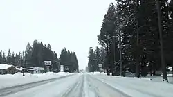 Downtown Lincoln in the winter | |
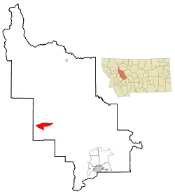 | |
 Lincoln Location in Montana  Lincoln Location in the United States | |
| Coordinates: 46°57′28″N 112°40′20″W | |
| Country | |
| State | |
| County | Lewis and Clark |
| Area | |
| • Total | 18.07 sq mi (46.79 km2) |
| • Land | 17.54 sq mi (45.44 km2) |
| • Water | 0.52 sq mi (1.34 km2) |
| Elevation | 4,541 ft (1,384 m) |
| Population (2010) | |
| • Total | 1,013 |
| • Density | 58/sq mi (22.3/km2) |
| Time zone | UTC−7 (Mountain (MST)) |
| • Summer (DST) | UTC−6 (MDT) |
| ZIP Code | 59639 |
| Area code(s) | 406 |
| FIPS code | 30-43675 |
| GNIS feature ID | 0801064 |
History
Meriwether Lewis passed through here on his return to St. Louis in 1806, following the famous "River of the Road to the Buffalo" created by Native Americans centuries before. Gold discoveries in the mid-1860s brought miners to a number of camps in the area, and Lincoln was eventually created when nearby Lincoln Gulch was abandoned in favor of the town's present location. Recreational, logging and mining activities along the Blackfoot River in the early 20th century made it a convenient commercial center. Nearby wilderness areas continue to attract visitors and residents.
The Lincoln Community Hall (1918) and the Hotel Lincoln (1914) are listed on the National Register of Historical Places.
"Unabomber" arrest
On April 3, 1996, federal officers arrested Theodore Kaczynski at his remote cabin 5 miles (8 km) south of Lincoln along Twin Gulch Drive, under suspicion of being the "Unabomber", a political terrorist who placed pressure-sensitive bombs inside mailed packages.[2] The bombing campaign resulted in three deaths and 23 wounded. Kaczynski is currently serving eight life sentences without the possibility of parole at ADX Florence Prison in Colorado.[3][4]
2017 earthquake
At 12:30 a.m. on July 6, 2017, there was a 5.8-magnitude earthquake about 6 miles (10 km) south of Lincoln.[5][6][7] The earthquake originated from a depth of nearly 3 miles (5 km) underground,[6] near a fault system known as the Lewis and Clark line, which runs 250 miles (400 km) from northern Idaho to east of Helena, Montana.[8] It was the eighth-strongest earthquake recorded in Montana.[9] There were at least nine more tremors nearby within the first hour after the earthquake, with magnitudes between 3.1 and 4.9.[6]
Geography and climate
Lincoln is located in western Lewis and Clark County at 46°57′28″N 112°40′20″W (46.957713, -112.672178).[10] The CDP contains the unincorporated center of Lincoln and extends 6 miles (10 km) east up the Blackfoot River valley and 3 miles (5 km) west, or down valley. Its elevation is 4,536 feet (1,383 m) above sea level. According to the United States Census Bureau, the CDP has a total area of 18.1 square miles (46.8 km2), of which 17.5 square miles (45.4 km2) are land and 0.50 square miles (1.3 km2), or 2.87%, are water.[11]
Lincoln is located on Montana Highway 200, the longest route signed as a state highway in the United States, running 706.6 miles (1,137.2 km) from Idaho to North Dakota. From Lincoln, the highway runs northeast up and over the Continental Divide 87 miles (140 km) to Great Falls and west 77 miles (124 km) to Missoula.
Lincoln has a humid continental climate (Dfb) bordering closely on a subarctic climate (Dfc). Summers are warm to hot while winters are cold and snowy, with annual average snowfall totaling 85.4 inches (217 cm).[12]
Rogers Pass, 18 miles (29 km) northeast of Lincoln on Highway 200, is known for being the location of the coldest recorded temperature in the United States outside of Alaska. On January 20, 1954, a temperature of −70 °F (−57 °C) was recorded. Lincoln has a humid continental climate bordering on semi-arid. Snow is usually dry powder, although strong Pacific Ocean storms sometimes bring moisture-laden snow to the area.
| Climate data for Lincoln, Montana | |||||||||||||
|---|---|---|---|---|---|---|---|---|---|---|---|---|---|
| Month | Jan | Feb | Mar | Apr | May | Jun | Jul | Aug | Sep | Oct | Nov | Dec | Year |
| Record high °F (°C) | 58 (14) |
70 (21) |
81 (27) |
90 (32) |
96 (36) |
100 (38) |
103 (39) |
102 (39) |
98 (37) |
84 (29) |
68 (20) |
55 (13) |
103 (39) |
| Average high °F (°C) | 33 (1) |
37 (3) |
45 (7) |
55 (13) |
64 (18) |
71 (22) |
81 (27) |
80 (27) |
69 (21) |
56 (13) |
39 (4) |
31 (−1) |
55 (13) |
| Average low °F (°C) | 10 (−12) |
15 (−9) |
19 (−7) |
26 (−3) |
33 (1) |
39 (4) |
42 (6) |
40 (4) |
32 (0) |
27 (−3) |
19 (−7) |
12 (−11) |
26 (−3) |
| Record low °F (°C) | −48 (−44) |
−44 (−42) |
−40 (−40) |
−8 (−22) |
8 (−13) |
19 (−7) |
24 (−4) |
15 (−9) |
0 (−18) |
−20 (−29) |
−53 (−47) |
−55 (−48) |
−55 (−48) |
| Average precipitation inches (mm) | 1.89 (48) |
1.35 (34) |
1.24 (31) |
1.35 (34) |
2.17 (55) |
2.26 (57) |
1.16 (29) |
1.32 (34) |
1.22 (31) |
1.23 (31) |
1.44 (37) |
1.75 (44) |
18.47 (469) |
| Source: Lincoln Ranger Station[13] | |||||||||||||
Demographics
| Historical population | |||
|---|---|---|---|
| Census | Pop. | %± | |
| 2000 | 1,100 | — | |
| 2010 | 1,013 | −7.9% | |
| U.S. Decennial Census | |||
As of the census[14] of 2010, there were 1,013 people, 507 households, and 296 families residing in the CDP. The population density was 56.6 people per square mile (21.8/km2). There were 846 housing units at an average density of 47.3 per square mile (18.2/km2). The racial makeup of the CDP was 95.46% White, 2.17% Native American, 0.20% Asian, and 1.88% from two or more races. Hispanic or Latino of any race were 1.48% of the population.
There were 507 households, out of which 16.6% had children under the age of 18 living with them, 48.3% were married couples living together, 6.7% had a female householder with no husband present, and 41.6% were non-families. 18.5% of all households were made up of individuals, and 33.9% had someone living alone who was 65 years of age or older. The average household size was 2.00 and the average family size was 2.55.
In the CDP, the population was spread out, with 16.3% under the age of 18, 3.7% from 18 to 24, 16.1% from 25 to 44, 41.2% from 45 to 64, and 22.8% who were 65 years of age or older. The median age was 53 years. For every 100 females, there were 108.4 males. For every 100 females age 18 and over, there were 107.3 males.
The median income for a household in the CDP was $26,688, and the median income for a family was $32,784. Males had a median income of $24,583 versus $15,227 for females. The per capita income for the CDP was $14,243. About 17.4% of families and 21.2% of the population were below the poverty line, including 28.8% of those under age 18 and 9.8% of those age 65 or over.
Education
Public education in Lincoln is administered by Lincoln Public School District #38.[15]
Lincoln has a public library, a branch of the Lewis & Clark Library.[16]
In popular culture
Nearby Bugle Mountain (also known as "Bugle Peak"), located in the Scapegoat Wilderness, was the setting of a forest fire in the fictional 1952 motion picture Red Skies of Montana. The film, based in part on the tragic 1949 Mann Gulch fire, was filmed in Montana.
Notable people
- Doug Swingley, four-time winner of the Iditarod Trail Sled Dog Race
- Ted Kaczynski, aka "Unabomber"
References
- "Total Population: 2010 Census DEC Summary File 1 (P1), Lincoln CDP, Montana". data.census.gov. U.S. Census Bureau. Retrieved April 27, 2020.
- Hardy, Quentin; Carley, William M.; Davidson, Joe. "Unabomber suspect held in Montana". Wall Street Journal. April 4, 1996. p. A3.
- Kovaleski, Serge F. (January 22, 2007). "Unabomber Wages Legal Battle to Halt the Sale of Papers". The New York Times. Retrieved July 3, 2008.
- "Theodore John Kaczynski." Federal Bureau of Prisons. Retrieved January 5, 2010.
- "5.8 magnitude earthquake rattles Helena area". Independent Record (Helena, Montana). July 6, 2017.
- "M 5.8 - 11km SSE of Lincoln, Montana". Earthquakes Hazard Program. United States Geological Survey. July 6, 2017.
- "Rare 5.8 earthquake strikes western Montana, the area's strongest temblor in nearly 60 years". Los Angeles Times. July 6, 2017.
- "Montana Earthquake: 5.8 Quake Strikes Outside Lincoln". Associated Press. NBC News. July 6, 2017.
- "US Gazetteer files: 2010, 2000, and 1990". United States Census Bureau. 2011-02-12. Retrieved 2011-04-23.
- "U.S. Gazetteer Files: 2019: Places: Montana". U.S. Census Bureau Geography Division. Retrieved April 27, 2020.
- "LINCOLN RANGER STN, MONTANA - Climate Summary". wrcc.dri.edu. Retrieved 2020-05-28.
- "Lincoln Ranger Stn, Montana (245040)". Lincoln, Montana climate. 2014. Retrieved 2018-03-21.
- "American FactFinder". United States Census Bureau. Archived from the original on 2020-02-14. Retrieved 2017-12-29.
- "Homepage". Lincoln Public Schools. Retrieved 14 June 2019.
- "Montana Public Libraries". PublicLibraries.com. Retrieved 14 June 2019.
External links
| Wikimedia Commons has media related to Lincoln, Montana. |
- Blackfoot Valley Dispatch, local newspaper
- Lincoln schools
Municipalities and communities of Lewis and Clark County, Montana, United States | ||
|---|---|---|
| City | 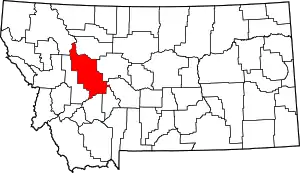 Lewis and Clark County map | |
| Town | ||
| CDPs | ||
| Other unincorporated communities | ||
| Ghost town | ||
| ||