List of Grade A listed buildings in County Antrim
This is a list of Grade A listed buildings in County Antrim, Northern Ireland.
In Northern Ireland, the term listed building refers to a building or other structure officially designated as being of "special architectural or historic interest".[1] Grade A structures are those considered to be "buildings of greatest importance to Northern Ireland including both outstanding architectural set-pieces and the least altered examples of each representative style, period and type."[2] Once listed, severe restrictions are imposed on the modifications allowed to a building's structure or its fittings. Listed building consent must be obtained from local authorities prior to any alteration to such a structure.[1]
Listing began later in Northern Ireland than in the rest of the UK: the first provision for listing was contained in the Planning (Northern Ireland) Order 1972;[3] and the current legislative basis for listing is the Planning (Northern Ireland) Order 1991.[2] Under Article 42 of the Order, the relevant Department of the Northern Ireland Executive is required to compile lists of buildings of "special architectural or historic interest". Since 2016, the responsibility for the listing process rests with the Historic Environment Division of the Department for Communities (DfC).[4]
Following the introduction of listing, an initial survey of Northern Ireland's building stock was begun in 1974.[5] By the time of the completion of this First Survey in 1994, the listing process had developed considerably, and it was therefore decided to embark upon a Second Survey, which is still ongoing, to update and cross-check the original information. Information gathered during this survey, relating to both listed and unlisted buildings, is entered into the publicly accessible Northern Ireland Buildings Database.[5] A range of listing criteria, which aim to define architectural and historic interest, are used to determine whether or not to list a building.[2]
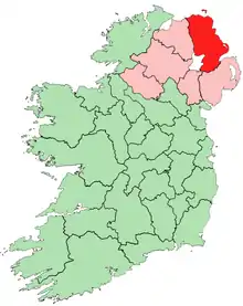
County Antrim covers 2,844 square kilometres (1,098 sq mi), and has a population of around 616,000. The County has 79 Grade A listed buildings, of which 37 are located within the city of Belfast.
Listed buildings
| Building address | Grid Ref.[note 1] Geo-coordinates |
Type [note 2] | Local authority | Second Survey | Original Survey | HB Number [note 3] | Image | Ref. |
|---|---|---|---|---|---|---|---|---|
| Randalstown Presbyterian Church (Old Congregation), Portglenone Road, Randalstown | 54°45′00″N 6°19′29″W | Church | Antrim | A | A | HB20/04/001 |  |
[6] |
| Shane's Castle Camellia House, Antrim | 54°43′37″N 6°16′07″W | Glass House | Antrim | A | A | HB20/04/042 A | 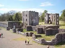 |
[7] |
| Shane's Castle ruins, Antrim | 54°43′38″N 6°16′07″W | Country House | Antrim | A | A | HB20/04/042 C | |
[8] |
| Terrace, Shane's Castle, Antrim | 54°43′36″N 6°16′07″W | Garden Features | Antrim | A | A | HB20/04/042 E | |
[9] |
| Court House, Market Square, Antrim | 54°42′54″N 6°13′17″W | Court House | Antrim | A | A | HB20/08/008 | |
[10] |
| All Saints Parish Church, Church Street, Antrim | 54°42′49″N 6°13′04″W | Church | Antrim | A | A | HB20/08/017 | |
[11] |
| Long Canals and Round Pond, Antrim Castle Gardens, Antrim | 54°43′07″N 6°13′26″W | Garden Features | Antrim | A | A | HB20/08/054 | 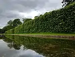 |
[12] |
| Castle Upton, Antrim Road, Templepatrick | 54°42′18″N 6°05′49″W | Country House | Antrim | A | A | HB20/12/018 A | 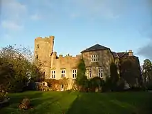 |
[13] |
| The Adam Yard, Castle Upton, Templepatrick | 54°42′20″N 6°05′47″W | House | Antrim | A | A | HB20/12/018 B-L | |
[14] |
| Entrance Gate and Lodges, Castle Upton | 54°42′12″N 6°05′46″W | Gates/ Screens/ Lodges | Antrim | A | B1 | HB20/12/018 M | |
[15] |
| Templeton Mausoleum, Castle Upton | 54°42′23″N 6°05′43″W | Mausoleum | Antrim | A | A | HB20/12/018 P | |
[16] |
| Former Control Tower, Langford Lodge Airfield, Largy Road, Crumlin | 54°36′55″N 6°18′26″W | World War II Structures | Antrim | A | Not listed | HB20/14/029 | |
[17] |
| Non-Subscribing Presbyterian Church, Main Street, Crumlin | 54°37′09″N 6°12′54″W | Church | Antrim | A | B+ | HB20/15/007 | _Presbyterian_Church_-_geograph.org.uk_-_67942.jpg.webp) |
[18] |
| Galgorm Castle, Ballymena | 54°51′26″N 6°19′00″W | Country House | Ballymena | – | A | HB07/15/001 A | 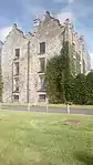 |
[19] |
| Moravian Church and 21 and 25 Church Road, Gracehill | 54°51′12″N 6°19′42″W | Church | Ballymena | – | A | HB07/15/002 | %252C_September_2009.JPG.webp) |
[20] |
| Early memorials in graveyard of Moravian Church, Gracehill | 54°51′12″N 6°19′42″W | Memorial | Ballymena | – | A | HB07/15/003 |  |
[21] |
| Benvarden, Ballybogey, Ballymoney | 55°08′14″N 6°30′58″W | Country House | Ballymoney | – | A | HB04/02/002 | 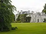 |
[22] |
| Leslie Hill, Ballypatrick, Ballymoney | 55°04′20″N 6°32′08″W | Country House | Ballymoney | – | A | HB04/15/008 | |
[23] |
| St. Peter's Cathedral, Belfast | 54°35′56″N 5°56′40″W | Church | Belfast | – | A | HB26/33/003 | 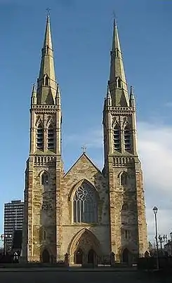 |
[24] |
| St. Mark's Church, Holywood Road, Dundela, Belfast | 54°36′11″N 5°52′29″W | Church | Belfast | – | A | HB26/12/017 | 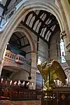 |
[25] |
| Main Building, Stranmillis College, Stranmillis Road, Belfast | 54°34′24″N 5°56′04″W | University/ College Building | Belfast | – | A | HB26/17/049 | .JPG.webp) |
[26] |
| The Palm House, Belfast Botanic Gardens, Stranmillis Road, Belfast | 54°35′01″N 5°56′01″W | Glass House | Belfast | – | A | HB26/27/003 | 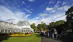 |
[27] |
| Assembly's College (Theological College Of Presbyterian Church), Botanic Avenue, Belfast | 54°35′06″N 5°55′53″W | University/ College Building | Belfast | – | A | HB26/27/004 | 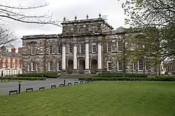 |
[28] |
| Lanyon Building, Queens University Belfast | 54°35′04″N 5°56′07″W | University/ College Building | Belfast | – | A | HB26/27/005 | 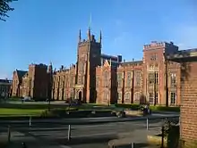 |
[29] |
| Elmwood Hall, Elmwood Avenue, Belfast | 54°35′03″N 5°56′15″W | Hall | Belfast | – | A | HB26/28/002 | 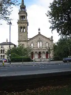 |
[30] |
| Grand Opera House, Great Victoria Street, Belfast | 54°35′43″N 5°56′06″W | Entertainment Building | Belfast | – | A | HB26/29/001 | 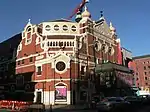 |
[31] |
| Crown Liquor Saloon, 46 Great Victoria Street, Belfast | 54°35′41″N 5°56′03″W | Public House | Belfast | – | A | HB26/30/003 | .jpg.webp) |
[32] |
| St. Malachy's Church, Alfred Street, Belfast | 54°35′39″N 5°55′37″W | Church | Belfast | – | A | HB26/30/023 | 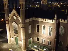 |
[33] |
| Ulster Hall, 1–7 Bedford Street, Belfast | 54°35′41″N 5°55′50″W | Entertainment Building | Belfast | A | – | HB26/30/057 | 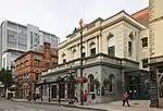 |
[34] |
| St. Matthew's Church, Woodvale Road, Belfast | 54°36′24″N 5°57′37″W | Church | Belfast | – | A | HB26/37/006 | |
[35] |
| County Gaol, Crumlin Road, Belfast | 54°36′32″N 5°56′33″W | Prison | Belfast | A | B1 | HB26/43/012 | 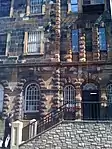 |
[36] |
| Belfast Charitable Institution (Clifton House), Clifton Street, Belfast | 54°36′23″N 5°56′00″W | Residential Home | Belfast | – | A | HB26/49/001 | 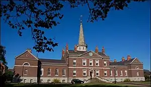 |
[37] |
| Belfast City Hall, Donegall Square, Belfast | 54°35′48″N 5°55′49″W | Town Hall | Belfast | – | A | HB26/50/001 | 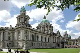 |
[38] |
| First Marquis of Dufferin Memorial, Donegall Square, Belfast | 54°35′47″N 5°55′52″W | Memorial | Belfast | – | A | HB26/50/002 | _-_geograph.org.uk_-_383944.jpg.webp) |
[39] |
| Boer War Monument, Donegall Square, Belfast | 54°35′47″N 5°55′44″W | Memorial | Belfast | – | A | HB26/50/003 | 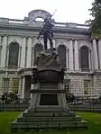 |
[40] |
| Cenotaph and Garden of Remembrance, Donegall Square, Belfast | 54°35′46″N 5°55′51″W | Memorial | Belfast | – | A | HB26/50/005 | 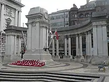 |
[41] |
| Titanic Monument, Donegall Square, Belfast | 54°35′48″N 5°55′44″W | Memorial | Belfast | – | A | HB26/50/006 | 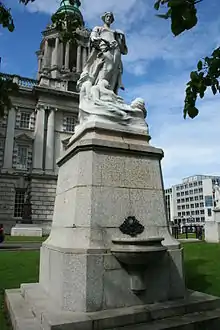 |
[42] |
| Sir Edward Harland Memorial, Donegall Square, Belfast | 54°35′49″N 5°55′45″W | Memorial | Belfast | – | A | HB26/50/007 | 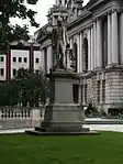 |
[43] |
| Sir Robert McMordie Memorial, Donegall Square, Belfast | 54°35′49″N 5°55′52″W | Memorial | Belfast | – | A | HB26/50/008 | 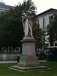 |
[44] |
| Sir Daniel Dixon Monument, Donegall Square, Belfast | 54°35′49″N 5°55′51″W | Memorial | Belfast | – | A | HB26/50/009 | |
[45] |
| Victoria Monument, Donegall Square, Belfast | 54°35′49″N 5°55′48″W | Memorial | Belfast | – | A | HB26/50/010 | 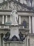 |
[46] |
| Sir James Haslett Memorial, Donegall Square, Belfast | 54°35′49″N 5°55′45″W | Memorial | Belfast | – | A | HB26/50/011 | 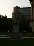 |
[47] |
| Former Water Office, 1 Donegall Square, Belfast | 54°35′51″N 5°55′45″W | Shop | Belfast | – | A | HB26/50/015 | |
[48] |
| Royal Belfast Academical Institution, College Square, Belfast | 54°35′49″N 5°56′11″W | School | Belfast | – | A | HB26/50/023 | |
[49] |
| St. George's Church, High Street, Belfast | 54°36′01″N 5°55′30″W | Church | Belfast | – | A | HB26/50/045 | %252C_October_2009.JPG.webp) |
[50] |
| McCausland's Building (Hotel), 34-38 Victoria Street, Belfast | 54°36′00″N 5°55′27″W | Office | Belfast | – | A | HB26/50/046 | .JPG.webp) |
[51] |
| First Presbyterian Church (Non-Subscribing), 41 Rosemary Street, Belfast | 54°36′01″N 5°55′47″W | Church | Belfast | – | A | HB26/50/054 | |
[52] |
| Former Ulster Bank Head Office, Waring Street, Belfast | 54°36′04″N 5°55′32″W | Hotel | Belfast | – | A | HB26/50/058 | 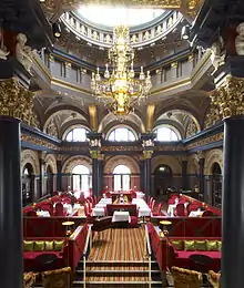 |
[53] |
| Custom House, Custom House Square, Belfast | 54°36′06″N 5°55′22″W | Office | Belfast | – | A | HB26/50/062 | 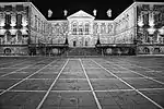 |
[54] |
| St. Anne's Cathedral, Donegall Street, Belfast | 54°36′10″N 5°55′44″W | Church | Belfast | – | A | HB26/50/067 | 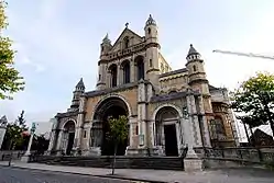 |
[55] |
| Clarendon Dock Buildings, Harbour Estate, Belfast | 54°36′22″N 5°55′15″W | Office | Belfast | – | A | HB26/50/090 | |
[56] |
| Harbour Office, Corporation Square, Belfast | 54°36′19″N 5°55′19″W | Office | Belfast | – | A | HB26/50/094 | |
[57] |
| Tesco (former Provincial Bank of Ireland), 2 Royal Avenue, Belfast | 54°35′58″N 5°55′51″W | Bank | Belfast | – | A | HB26/50/106 | |
[58] |
| Old Museum Buildings, 7 College Square, Belfast | 54°35′51″N 5°56′18″W | Gallery/ Museum | Belfast | – | A | HB26/50/112 | |
[59] |
| Royal Courts Of Justice, Chichester Street, Belfast | 54°35′50″N 5°55′20″W | Court House | Belfast | – | A | HB26/50/180 | 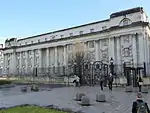 |
[60] |
| McHugh's Bar, 31-33 Queen's Square, Belfast | 54°36′03″N 5°55′23″W | Public House | Belfast | – | A | HB26/50/274 | %252C_October_2009.JPG.webp) |
[61] |
| St. Nicholas' Church, Lancasterian Street, Carrickfergus | 54°42′54″N 5°48′31″W | Church | Carrickfergus | – | A | HB22/08/001 | |
[62] |
| Castle Dobbs, Tongue Loanen, Carrickfergus | 54°44′38″N 5°45′30″W | Country House | Carrickfergus | A | A | HB22/13/001 A | |
[63] |
| Glenarm Castle, Glenarm | 54°57′58″N 5°57′24″W | Country House | Larne | A | A | HB06/02/001 A | 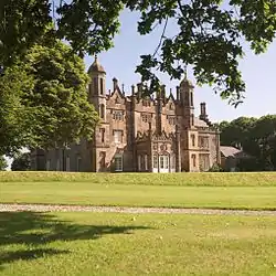 |
[64] |
| Ballygally Castle, Coast Road, Ballygalley, Larne | 54°53′56″N 5°51′42″W | Hotel | Larne | A | A | HB06/03/011 | 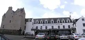 |
[65] |
| The Brewhouse and walling, Red Hall, Ballycarry | 54°46′54″N 5°44′51″W | House | Larne | A | A | HB06/05/013 A | |
[66] |
| Red Hall, Ballycarry | 54°46′53″N 5°44′51″W | Country House | Larne | A | A | HB06/05/013 B | |
[67] |
| 4 Trummery Lane, Trummery, Maghaberry | 54°29′59″N 6°11′18″W | House | Lisburn | A | A | HB19/03/048 | |
[68] |
| Christ Church Cathedral, Market Square, Lisburn | 54°30′40″N 6°02′35″W | Church | Lisburn | A | A | HB19/16/001 |  |
[69] |
| Fountain, Castle Gardens, Lisburn | 54°30′43″N 6°02′25″W | Fountain | Lisburn | – | A | HB19/16/015 | 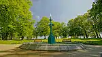 |
[70] |
| Christ Church, Derriaghy, Lisburn | 54°32′33″N 6°01′56″W | Church | Lisburn | – | A | HB19/18/008 | _-_geograph.org.uk_-_58794.jpg.webp) |
[71] |
| First Presbyterian Church (Non-Subscribing), Dunmurry | 54°33′03″N 6°00′27″W | Church | Lisburn | – | A | HB19/20/005 | |
[72] |
| Holy Trinity Church, The Diamond, Ballycastle | 55°12′02″N 6°15′00″W | Church | Moyle | A | A | HB05/14/001 | 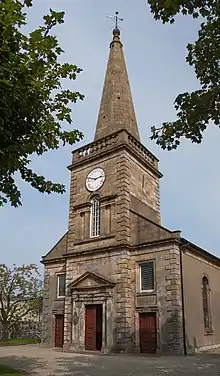 |
[73] |
| Railway Viaduct (1), Bleach Green Junction, Newtownabbey | 54°40′51″N 5°54′10″W | Viaduct | Newtownabbey | A | B1 | HB21/10/001 A | |
[74] |
| Railway Viaduct (2), Bleach Green Junction, Newtownabbey | 54°40′51″N 5°54′08″W | Viaduct | Newtownabbey | A | B1 | HB21/10/001 B | |
[75] |
| Church of St Patrick, Jordanstown Road, Jordanstown | 54°41′20″N 5°53′56″W | Church | Newtownabbey | A | A | HB21/11/001 | |
[76] |
Notes
- Sometimes known as OSGB36, the grid reference is based on the British national grid reference system used by the Ordnance Survey.
- The type of structure, as identified by the DfC.
- The "HB Number" is a unique number assigned to each listed building by the DfC.
| Wikimedia Commons has media related to Grade A listed buildings in County Antrim. |
References
- "Planning Policy Statement 6: Planning, Archaeology, and the Built Heritage" (PDF). Planning Service. March 1999. p. 22. Retrieved 2010-06-30.
- "Planning Policy Statement 6 Planning, Archaeology and the Built Heritage Revised Annex C: Criteria for Listing" (.pdf). DOENI. 2011. Retrieved 8 February 2017.
- Legislation providing for the listing of buildings in England, Wales and Scotland was enacted in 1947.
- "Structure and Contents in the Historic Environment Division" (PDF). Department for Communities. December 2016. Archived from the original (PDF) on 2017-01-05. Retrieved 2017-02-08.
- "Second Survey". Department for Communities. Retrieved 8 February 2017.
- Randalstown Presbyterian Church: Historic Building Details. Northern Ireland Buildings Database. Northern Ireland Environment Agency. Retrieved 2010-06-25.
- Shane's Castle Camellia House: Historic Building Details. Northern Ireland Buildings Database. Northern Ireland Environment Agency. Retrieved 2010-06-25.
- Shane's Castle: Historic Building Details Archived 2015-05-29 at the Wayback Machine. Northern Ireland Buildings Database. Northern Ireland Environment Agency. Retrieved 2010-06-25.
- Terrace, Shane's Castle: Historic Building Details. Northern Ireland Buildings Database. Northern Ireland Environment Agency. Retrieved 2010-06-25.
- Court House, Market Square, Antrim: Historic Building Details. Northern Ireland Buildings Database. Northern Ireland Environment Agency. Retrieved 2010-06-25.
- All Saints Parish Church, Church Street, Antrim: Historic Building Details. Northern Ireland Buildings Database. Northern Ireland Environment Agency. Retrieved 2010-06-25.
- Long Canals and Round Pond, Antrim Castle: Historic Building Details. Northern Ireland Buildings Database. Northern Ireland Environment Agency. Retrieved 2010-06-25.
- Castle Upton: Historic Building Details Archived 2015-05-27 at the Wayback Machine. Northern Ireland Buildings Database. Northern Ireland Environment Agency. Retrieved 2010-06-25.
-
- The Studio House, No 1 The Adam Yard: Historic Building Details. Northern Ireland Buildings Database. Northern Ireland Environment Agency. Retrieved 2010-06-25
- Clock Tower Flat, No 2 The Adam Yard: Historic Building Details. Northern Ireland Buildings Database. Northern Ireland Environment Agency. Retrieved 2010-06-25
- The Adam House, No 3 The Adam Yard: Historic Building Details. Northern Ireland Buildings Database. Northern Ireland Environment Agency. Retrieved 2010-06-25
- Stable Flat, No 4 The Adam Yard: Historic Building Details. Northern Ireland Buildings Database. Northern Ireland Environment Agency. Retrieved 2010-06-25.
- The Saddle House, No 5 The Adam Yard: Historic Building Details. Northern Ireland Buildings Database. Northern Ireland Environment Agency. Retrieved 2010-06-25
- The Cobweb House, No 7 The Adam Yard: Historic Building Details. Northern Ireland Buildings Database. Northern Ireland Environment Agency. Retrieved 2010-06-25
- The Barn House, No 8 The Adam Yard: Historic Building Details. Northern Ireland Buildings Database. Northern Ireland Environment Agency. Retrieved 2010-06-25
- The Swallow House, No 9 The Adam Yard: Historic Building Details. Northern Ireland Buildings Database. Northern Ireland Environment Agency. Retrieved 2010-06-25
- The Peacock House, No 11 The Adam Yard: Historic Building Details. Northern Ireland Buildings Database. Northern Ireland Environment Agency. Retrieved 2010-06-25
- The Oat House, No 12 The Adam Yard: Historic Building Details. Northern Ireland Buildings Database. Northern Ireland Environment Agency. Retrieved 2010-06-25.
- Entrance Gate & Lodges, Castle Upton: Historic Building Details. Northern Ireland Buildings Database. Northern Ireland Environment Agency. Retrieved 2010-06-25.
- Templeton Mausoleum, Castle Upton: Historic Building Details. Northern Ireland Buildings Database. Northern Ireland Environment Agency. Retrieved 2010-06-25.
- Former Control Tower, Langford Lodge Airfield: Historic Building Details. Northern Ireland Buildings Database. Northern Ireland Environment Agency. Retrieved 2010-06-25.
- Non-Subscribing Presbyterian Church, Crumlin: Historic Building Details. Northern Ireland Buildings Database. Northern Ireland Environment Agency. Retrieved 2010-06-25.
- Galgorm Castle: Historic Building Details. Northern Ireland Buildings Database. Northern Ireland Environment Agency. Retrieved 2010-06-25.
- Moravian Church and 21 and 25 Church Road, Gracehill: Historic Building Details. Northern Ireland Buildings Database. Northern Ireland Environment Agency. Retrieved 2010-06-25.
- Early memorials in graveyard of Moravian Church: Historic Building Details. Northern Ireland Buildings Database. Northern Ireland Environment Agency. Retrieved 2010-06-25.
- Benvarden: Historic Building Details. Northern Ireland Buildings Database. Northern Ireland Environment Agency. Retrieved 2010-06-25.
- Leslie Hill: Historic Building Details. Northern Ireland Buildings Database. Northern Ireland Environment Agency. Retrieved 2010-06-25.
- St. Peter's Cathedral, Belfast: Historic Building Details. Northern Ireland Buildings Database. Northern Ireland Environment Agency. Retrieved 2010-06-30.
- St. Mark's Church, Holywood Road, Dundela, Belfast: Historic Building Details. Northern Ireland Buildings Database. Northern Ireland Environment Agency. Retrieved 2010-06-30.
- Main Building, Stranmillis College, Stranmillis Road, Belfast: Historic Building Details. Northern Ireland Buildings Database. Northern Ireland Environment Agency. Retrieved 2010-06-30.
- The Palm House, Belfast Botanic Gardens, Stranmillis Road, Belfast: Historic Building Details. Northern Ireland Buildings Database. Northern Ireland Environment Agency. Retrieved 2010-06-30.
- Assembly's College (Theological College Of Presbyterian Church), Botanic Avenue, Belfast: Historic Building Details. Northern Ireland Buildings Database. Northern Ireland Environment Agency. Retrieved 2010-06-30.
- Lanyon Building, Queens University Belfast: Historic Building Details. Northern Ireland Buildings Database. Northern Ireland Environment Agency. Retrieved 2010-06-30.
- Elmwood Hall, Elmwood Avenue, Belfast: Historic Building Details. Northern Ireland Buildings Database. Northern Ireland Environment Agency. Retrieved 2010-06-30.
- Grand Opera House, Great Victoria Street, Belfast: Historic Building Details. Northern Ireland Buildings Database. Northern Ireland Environment Agency. Retrieved 2010-06-30.
- Crown Liquor Saloon, 46 Great Victoria Street, Belfast: Historic Building Details. Northern Ireland Buildings Database. Northern Ireland Environment Agency. Retrieved 2010-06-30.
- St. Malachy's Church, Alfred Street, Belfast: Historic Building Details. Northern Ireland Buildings Database. Northern Ireland Environment Agency. Retrieved 2010-06-30.
- "Ulster Hall 1-7 Bedford Street Belfast Co. Antrim BT2 7FF: Historic Building Details". Department for Communities, Northern Ireland. 20 April 2011. Retrieved 24 November 2018.
- St. Matthew's Church, Woodvale Road, Belfast: Historic Building Details. Northern Ireland Buildings Database. Northern Ireland Environment Agency. Retrieved 2010-06-30.
- County Gaol, Crumlin Road, Belfast: Historic Building Details. Northern Ireland Buildings Database. Northern Ireland Environment Agency. Retrieved 2010-06-30.
- Belfast Charitable Institution (Clifton House), Clifton Street, Belfast: Historic Building Details. Northern Ireland Buildings Database. Northern Ireland Environment Agency. Retrieved 2010-06-30.
- Belfast City Hall, Donegall Square, Belfast: Historic Building Details. Northern Ireland Buildings Database. Northern Ireland Environment Agency. Retrieved 2010-06-30.
- First Marquis of Dufferin Memorial, Donegall Square, Belfast: Historic Building Details. Northern Ireland Buildings Database. Northern Ireland Environment Agency. Retrieved 2010-06-30.
- Boer War Monument, Donegall Square, Belfast: Historic Building Details. Northern Ireland Buildings Database. Northern Ireland Environment Agency. Retrieved 2010-06-30.
- Cenotaph and Garden of Remembrance, Donegall Square, Belfast: Historic Building Details. Northern Ireland Buildings Database. Northern Ireland Environment Agency. Retrieved 2010-06-30.
- Titanic Monument, Donegall Square, Belfast: Historic Building Details. Northern Ireland Buildings Database. Northern Ireland Environment Agency. Retrieved 2010-06-30.
- Sir Edward Harland Memorial, Donegall Square, Belfast: Historic Building Details. Northern Ireland Buildings Database. Northern Ireland Environment Agency. Retrieved 2010-06-30.
- Sir Robert McMordie Memorial, Donegall Square, Belfast: Historic Building Details. Northern Ireland Buildings Database. Northern Ireland Environment Agency. Retrieved 2010-06-30.
- Sir Daniel Dixon Monument, Donegall Square, Belfast: Historic Building Details. Northern Ireland Buildings Database. Northern Ireland Environment Agency. Retrieved 2010-06-30.
- Victoria Monument, Donegall Square, Belfast: Historic Building Details. Northern Ireland Buildings Database. Northern Ireland Environment Agency. Retrieved 2010-06-30.
- Sir James Haslett Memorial, Donegall Square, Belfast: Historic Building Details. Northern Ireland Buildings Database. Northern Ireland Environment Agency. Retrieved 2010-06-30.
- The former Water Office, 1 Donegall Square, Belfast: Historic Building Details. Northern Ireland Buildings Database. Northern Ireland Environment Agency. Retrieved 2010-06-30.
- Royal Belfast Academical Institution, College Square, Belfast: Historic Building Details. Northern Ireland Buildings Database. Northern Ireland Environment Agency. Retrieved 2010-06-30.
- St. George's Church, High Street, Belfast: Historic Building Details. Northern Ireland Buildings Database. Northern Ireland Environment Agency. Retrieved 2010-06-30.
- McCausland's Building (Hotel), 34-38 Victoria Street, Belfast: Historic Building Details. Northern Ireland Buildings Database. Northern Ireland Environment Agency. Retrieved 2010-06-30.
- First Presbyterian Church (Non-Subscribing), 41 Rosemary Street, Belfast: Historic Building Details. Northern Ireland Buildings Database. Northern Ireland Environment Agency. Retrieved 2010-06-30.
- Former Ulster Bank Head Office, Waring Street, Belfast: Historic Building Details. Northern Ireland Buildings Database. Northern Ireland Environment Agency. Retrieved 2010-06-30.
- Custom House, Custom House Square, Belfast: Historic Building Details. Northern Ireland Buildings Database. Northern Ireland Environment Agency. Retrieved 2010-06-30.
- St. Anne's Cathedral, Donegall Street, Belfast: Historic Building Details. Northern Ireland Buildings Database. Northern Ireland Environment Agency. Retrieved 2010-06-30.
- Clarendon Dock Buildings, Harbour Estate, Belfast: Historic Building Details. Northern Ireland Buildings Database. Northern Ireland Environment Agency. Retrieved 2010-06-30.
- Harbour Office, Corporation Square, Belfast: Historic Building Details. Northern Ireland Buildings Database. Northern Ireland Environment Agency. Retrieved 2010-06-30.
- Tesco (former Provincial Bank of Ireland), 2 Royal Avenue, Belfast: Historic Building Details. Northern Ireland Buildings Database. Northern Ireland Environment Agency. Retrieved 2010-06-30.
- Old Museum Buildings, 7 College Square, Belfast: Historic Building Details. Northern Ireland Buildings Database. Northern Ireland Environment Agency. Retrieved 2010-06-30.
- Royal Courts Of Justice, Chichester Street, Belfast: Historic Building Details. Northern Ireland Buildings Database. Northern Ireland Environment Agency. Retrieved 2010-06-30.
- McHugh's Bar, 31-33 Queen's Square, Belfast: Historic Building Details. Northern Ireland Buildings Database. Northern Ireland Environment Agency. Retrieved 2010-06-30.
- St. Nicholas' Church, Carrickfergus: Historic Building Details. Northern Ireland Buildings Database. Northern Ireland Environment Agency. Retrieved 2010-06-25.
- Castle Dobbs: Historic Building Details. Northern Ireland Buildings Database. Northern Ireland Environment Agency. Retrieved 2010-06-25.
- Glenarm Castle: Historic Building Details. Northern Ireland Buildings Database. Northern Ireland Environment Agency. Retrieved 2010-06-25.
- Ballygally Castle: Historic Building Details. Northern Ireland Buildings Database. Northern Ireland Environment Agency. Retrieved 2010-06-25.
- The Brewhouse and walling, Red Hall: Historic Building Details. Northern Ireland Buildings Database. Northern Ireland Environment Agency. Retrieved 2010-06-25.
- Red Hall: Historic Building Details. Northern Ireland Buildings Database. Northern Ireland Environment Agency. Retrieved 2010-06-25.
- 4 Trummery Lane, Maghaberry: Historic Building Details. Northern Ireland Buildings Database. Northern Ireland Environment Agency. Retrieved 2010-06-25.
- Christ Church Cathedral, Lisburn: Historic Building Details. Northern Ireland Buildings Database. Northern Ireland Environment Agency. Retrieved 2010-06-25.
- Fountain, Castle Gardens, Lisburn: Historic Building Details. Northern Ireland Buildings Database. Northern Ireland Environment Agency. Retrieved 2010-06-25.
- Christ Church, Derriaghy: Historic Building Details. Northern Ireland Buildings Database. Northern Ireland Environment Agency. Retrieved 2010-06-25.
- "First Presbyterian Church (Non-Subscribing), Dunmurry: Historic Building Details". Northern Ireland Buildings Database. Northern Ireland Environment Agency. Retrieved 2010-06-25.
- Holy Trinity Church, Ballycastle: Historic Building Details. Northern Ireland Buildings Database. Northern Ireland Environment Agency. Retrieved 2010-06-25.
- Railway Viaduct (1), Bleach Green Junction: Historic Building Details. Northern Ireland Buildings Database. Northern Ireland Environment Agency. Retrieved 2010-06-25.
- Railway Viaduct (2), Bleach Green Junction: Historic Building Details. Northern Ireland Buildings Database. Northern Ireland Environment Agency. Retrieved 2010-06-25.
- Church of St Patrick, Jordanstown: Historic Building Details. Northern Ireland Buildings Database. Northern Ireland Environment Agency. Retrieved 2010-06-25.