List of Grade A listed buildings in County Down
This is a list of Grade A listed buildings in County Down, Northern Ireland.
In Northern Ireland, the term listed building refers to a building or other structure officially designated as being of "special architectural or historic interest".[1] Grade A structures are those considered to be "buildings of greatest importance to Northern Ireland including both outstanding architectural set-pieces and the least altered examples of each representative style, period and type."[2] Once listed, severe restrictions are imposed on the modifications allowed to a building's structure or its fittings. Listed building consent must be obtained from local authorities prior to any alteration to such a structure.[1]
Listing began later in Northern Ireland than in the rest of the UK: the first provision for listing was contained in the Planning (Northern Ireland) Order 1972;[3] and the current legislative basis for listing is the Planning (Northern Ireland) Order 1991.[2] Under Article 42 of the Order, the relevant Department of the Northern Ireland Executive is required to compile lists of buildings of "special architectural or historic interest". Since 2016, the responsibility for the listing process rests with the Historic Environment Division of the Department for Communities (DfC).[4]
Following the introduction of listing, an initial survey of Northern Ireland's building stock was begun in 1974.[5] By the time of the completion of this First Survey in 1994, the listing process had developed considerably, and it was therefore decided to embark upon a Second Survey, which is still ongoing, to update and cross-check the original information. Information gathered during this survey, relating to both listed and unlisted buildings, is entered into the publicly accessible Northern Ireland Buildings Database.[5] A range of listing criteria, which aim to define architectural and historic interest, are used to determine whether or not to list a building.[2]
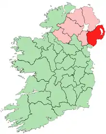
County Down covers 2,448 square kilometres (945 sq mi), and has a population of around 516,000. The County has 41 Grade A listed buildings.
Listed buildings
| Building address | Grid Ref.[note 1] Geo-coordinates |
Type [note 2] | Local authority | Second Survey | Original Survey | HB Number [note 3] | Image | Ref. |
|---|---|---|---|---|---|---|---|---|
| Portaferry Presbyterian Church, Meeting House Street, Portaferry | 54°22′51″N 5°32′45″W | Church | Ards | A | B+ | HB24/01/046 | %252C_October_2009.JPG.webp) |
[6] |
| Rosemount House, Rosemount, Greyabbey | 54°32′03″N 5°33′22″W | Country House | Ards | A | A | HB24/04/017 A |  |
[7] |
| Ballywalter Park House and garden walling, Ballywalter | 54°32′35″N 5°29′32″W | Country House | Ards | A | A | HB24/04/028 | |
[8] |
| The Temple of the Winds, Mount Stewart, Newtownards | 54°32′47″N 5°35′33″W | Estate Related Structures | Ards | A | A | HB24/04/051 | |
[9] |
| Mount Stewart and garden walls, Newtownards | 54°33′05″N 5°36′09″W | Country House | Ards | A | A | HB24/04/052 A | 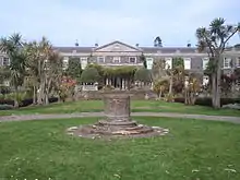 |
[10] |
| The Manor House, High Street, Donaghadee | 54°38′27″N 5°32′08″W | House | Ards | A | B | HB24/07/009 A | |
[11] |
| St. Mark's (Church of Ireland) Parish Church, Church Street, Newtownards | 54°35′42″N 5°42′14″W | Church | Ards | A | A | HB24/11/001 |  |
[12] |
| Moyallen Friends Meeting House, 117 Stramore Road, Gilford | 54°23′27″N 6°23′08″W | Church | Banbridge | – | A | HB17/01/022 | |
[13] |
| Cleland Mausoleum, Dundonald Parish Graveyard, Dundonald | 54°35′37″N 5°48′23″W | Memorial | Castlereagh | – | A | HB25/05/002 | 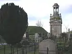 |
[14] |
| Knockbreda Church (Church of Ireland), Church Road, Knockbreda | 54°33′42″N 5°54′44″W | Church | Castlereagh | – | A | HB25/16/005 A |  |
[15] |
| Waringstown House, Magherana, Waringstown | 54°25′49″N 6°17′56″W | House | Craigavon | – | A | HB14/06/001 | _-_geograph.org.uk_-_1432594.jpg.webp) |
[16] |
| Killyleagh Castle, Killyleagh | 54°24′09″N 5°39′15″W | Country House | Down | – | A | HB18/03/001 A | 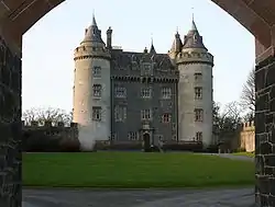 |
[17] |
| The Bawn, Killyleagh Castle | 54°24′25″N 5°39′09″W | Walling | Down | – | A | HB18/03/001 B | |
[18] |
| Gatehouse screen at Killyleagh Castle | 54°24′25″N 5°39′09″W | Gates/ Screens/ Lodges | Down | – | A | HB18/03/002 | |
[19] |
| North east gateway, Killyleagh Castle | 54°24′10″N 5°39′15″W | Gates/ Screens/ Lodges | Down | – | A | HB18/03/003 | _-_geograph.org.uk_-_322123.jpg.webp) |
[20] |
| Rademon Unitarian Meeting House, Listooder Road, Crossgar, Downpatrick | 54°24′21″N 5°48′40″W | Church | Down | A | A | HB18/05/022 | |
[21] |
| Castle Ward House, Castleward, Strangford, Downpatrick | 54°22′03″N 5°34′50″W | Country House | Down | – | A | HB18/08/065 | .JPG.webp) |
[22] |
| Southwell Charity School and Almshouses, English Street, Downpatrick | 54°19′41″N 5°43′13″W | School | Down | – | A | HB18/20/001 |  |
[23] |
| Downpatrick First (Non-Subscribing) Presbyterian Church, Stream Street, Downpatrick | 54°19′30″N 5°42′44″W | Church | Down | A | B+ | HB18/19/016 |  |
[24] |
| Holy Trinity Cathedral, English Street, Downpatrick | 54°19′37″N 5°43′21″W | Church | Down | – | A | HB18/20/005 | %252C_August_2009.JPG.webp) |
[25] |
| Cathedral of St. Patrick and St. Colman, Hill Street, Newry | 54°10′27″N 6°20′19″W | Church | Newry and Mourne | A | A | HB16/28/036 | 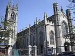 |
[26] |
| Parish Church of St. Mary (Church of Ireland), John Mitchel Place, Newry | 54°10′20″N 6°20′21″W | Church | Newry and Mourne | A | A | HB16/30/001 | 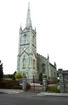 |
[27] |
| Ross Monument, Warrenpoint Road, Rostrevor | 54°05′58″N 6°12′34″W | Memorial | Newry and Mourne | – | A | HB16/06/056 |  |
[28] |
| Narrow Water Castle, Newry Road, Warrenpoint | 54°19′30″N 5°42′44″W | Hotel | Newry and Mourne | A | A | HB16/11/019 A | 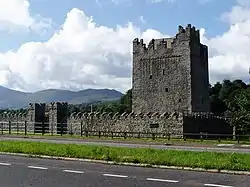 |
[note 4][29] |
| Derrymore House, Bessbrook, Newry | 54°11′22″N 6°23′03″W | Gallery/ Museum | Newry and Mourne | A | A | HB16/23/010 | |
[30] |
| Rathmoyle, Craigdarragh Road, Helen's Bay, Bangor | House | North Down | – | A | HB23/16/030 | |
[31] | |
| Bangor Old Custom House, Quay Street, Bangor | 54°39′53″N 5°40′03″W | House | North Down | – | A | HB23/05/012 |  |
[32] |
| Helen's Tower, Conlig | 54°37′22″N 5°41′40″W | Tower | North Down | – | A | HB23/06/009 | 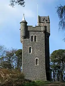 |
[33] |
| Town Hall, Bangor Castle, Bangor | 54°39′23″N 5°40′10″W | Town Hall | North Down | – | A | HB23/07/001 A |  |
[34] |
| Local Heritage and Visitor's Centre, Bangor Castle, Bangor | 54°39′23″N 5°40′10″W | Gallery/ Museum | North Down | – | A | HB23/07/001 B | |
[35] |
| Bangor Abbey Parish Church, Bangor | 54°39′20″N 5°40′30″W | Church | North Down | – | A | HB23/07/004 | 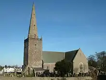 |
[36] |
| 3 Station Square, Helen's Bay | 54°40′00″N 5°44′27″W | House | North Down | – | A | HB23/15/033 | |
[37] |
| Station Building, Helen's Bay Station, Helen's Bay | 54°40′00″N 5°44′28″W | Railway Station Structures | North Down | – | A | HB23/15/034 | 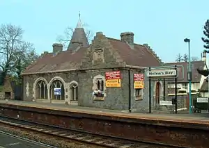 |
[38] |
| Station Platforms, Helen's Bay Station | 54°39′59″N 5°44′27″W | Railway Station Structures | North Down | – | A | HB23/15/035 | _-_geograph.org.uk_-_768614.jpg.webp) |
[39] |
| Railway Bridge, Helen's Bay Station | 54°40′00″N 5°44′29″W | Bridge | North Down | – | A | HB23/15/036 | |
[40] |
| Coach Yard, Helen's Bay Station | 54°40′00″N 5°44′28″W | Outbuildings | North Down | – | A | HB23/15/037 | |
[41] |
| Parish Church of St. Malachi, Main Street, Hillsborough | 54°27′42″N 6°04′51″W | Church | Lisburn | – | A | HB19/05/001 | 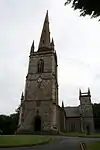 |
[42] |
| Gate screen and lodges (aka Sexton's House) at Parish Church Of St. Malachi, Hillsborough | 54°27′45″N 6°04′59″W | Gates/ Screens/ Lodges | Lisburn | – | A | HB19/05/002 | .JPG.webp) |
[43] |
| Marquis of Downshire Monument, Monument Road, Hillsborough | 54°27′25″N 6°05′31″W | Memorial | Lisburn | – | A |  |
[44] | |
| Larchfield House, Upper Ballynahinch Road, Lisburn | 54°27′30″N 5°58′47″W | House | Lisburn | – | A | HB19/06/003 |  |
[45] |
| St. John's Parish Church, Moira | 54°28′50″N 6°13′13″W | Church | Lisburn | – | A | HB19/22/001 |  |
[46] |
Notes
- Sometimes known as OSGB36, the grid reference is based on the British national grid reference system used by the Ordnance Survey.
- The type of structure, as identified by the DfC.
- The "HB Number" is a unique number assigned to each listed building by the DfC.
- The 19th-century house, not the 16th-century tower
| Wikimedia Commons has media related to Grade A listed buildings in County Down. |
References
- "Planning Policy Statement 6: Planning, Archaeology, and the Built Heritage" (PDF). Planning Service. March 1999. p. 22. Retrieved 2010-06-30.
- "Planning Policy Statement 6 Planning, Archaeology and the Built Heritage Revised Annex C: Criteria for Listing" (.pdf). DOENI. 2011. Retrieved 8 February 2017.
- Legislation providing for the listing of buildings in England, Wales and Scotland was enacted in 1947.
- "Structure and Contents in the Historic Environment Division" (PDF). Department for Communities. December 2016. Archived from the original (PDF) on 2017-01-05. Retrieved 2017-02-08.
- "Second Survey". Department for Communities. Retrieved 8 February 2017.
- Portaferry Presbyterian Church, Meeting House Street, Portaferry: Historic Building Details. Northern Ireland Buildings Database. Northern Ireland Environment Agency. Retrieved 2010-07-05.
- Rosemount House, Rosemount, Greyabbey: Historic Building Details. Northern Ireland Buildings Database. Northern Ireland Environment Agency. Retrieved 2010-07-05.
- Ballywalter Park House and garden walling, Ballywalter: Historic Building Details. Northern Ireland Buildings Database. Northern Ireland Environment Agency. Retrieved 2010-07-05.
- The Temple of the Winds, Mount Stewart, Newtownards : Historic Building Details. Northern Ireland Buildings Database. Northern Ireland Environment Agency. Retrieved 2010-07-05.
- Mount Stewart and garden walls, Newtownards : Historic Building Details. Northern Ireland Buildings Database. Northern Ireland Environment Agency. Retrieved 2010-07-05.
- The Manor House, High Street, Donaghadee: Historic Building Details. Northern Ireland Buildings Database. Northern Ireland Environment Agency. Retrieved 2010-07-05.
- St. Mark's (Church of Ireland) Parish Church, Church Street, Newtownards: Historic Building Details. Northern Ireland Buildings Database. Northern Ireland Environment Agency. Retrieved 2010-07-05.
- Moyallen Friends Meeting House, 117 Stramore Road, Gilford: Historic Building Details. Northern Ireland Buildings Database. Northern Ireland Environment Agency. Retrieved 2010-07-05.
- Cleland Mausoleum, Dundonald Parish Graveyard, Dundonald: Historic Building Details. Northern Ireland Buildings Database. Northern Ireland Environment Agency. Retrieved 2010-06-30.
- Knockbreda Church (Church of Ireland), Church Road, Knockbreda: Historic Building Details. Northern Ireland Buildings Database. Northern Ireland Environment Agency. Retrieved 2010-06-30.
- Waringstown House, Magherana, Waringstown: Historic Building Details. Northern Ireland Buildings Database. Northern Ireland Environment Agency. Retrieved 2010-07-05.
- Killyleagh Castle, Killyleagh: Historic Building Details. Northern Ireland Buildings Database. Northern Ireland Environment Agency. Retrieved 2010-07-05.
- The Bawn, Killyleagh Castle: Historic Building Details. Northern Ireland Buildings Database. Northern Ireland Environment Agency. Retrieved 2010-07-05.
- Gatehouse Screen at Killyleagh Castle: Historic Building Details. Northern Ireland Buildings Database. Northern Ireland Environment Agency. Retrieved 2010-07-05.
- North East Gateway, Killyleagh Castle: Historic Building Details. Northern Ireland Buildings Database. Northern Ireland Environment Agency. Retrieved 2010-07-05.
- Rademon Unitarian Meeting House, Listooder Road, Rademan Crossgar Downpatrick: Historic Building Details. Northern Ireland Buildings Database. Northern Ireland Environment Agency. Retrieved 2010-07-05.
- Castleward House, Castleward, Strangford, Downpatrick: Historic Building Details. Northern Ireland Buildings Database. Northern Ireland Environment Agency. Retrieved 2010-07-05.
- Southwell Charity School and Almshouses, English Street, Downpatrick: Historic Building Details. Northern Ireland Buildings Database. Northern Ireland Environment Agency. Retrieved 2010-07-05.
- Downpatrick First (Non-Subscribing) Presbyterian Church, Stream Street, Downpatrick : Historic Building Details. Northern Ireland Buildings Database. Northern Ireland Environment Agency. Retrieved 2010-07-05.
- Holy Trinity Cathedral, English Street, Downpatrick: Historic Building Details. Northern Ireland Buildings Database. Northern Ireland Environment Agency. Retrieved 2010-07-05.
- Cathedral of St. Patrick and St. Colman, Hill Street, Newry : Historic Building Details. Northern Ireland Buildings Database. Northern Ireland Environment Agency. Retrieved 2010-07-05.
- Parish Church of St. Mary (Church of Ireland), John Mitchel Place, Newry: Historic Building Details. Northern Ireland Buildings Database. Northern Ireland Environment Agency. Retrieved 2010-07-05.
- Ross Monument, Warrenpoint Road, Rostrevor: Historic Building Details. Northern Ireland Buildings Database. Northern Ireland Environment Agency. Retrieved 2010-07-05.
- Narrow Water Castle, Newry Road, Warrenpoint : Historic Building Details. Northern Ireland Buildings Database. Northern Ireland Environment Agency. Retrieved 2010-07-05.
- Derrymore House, Bessbrook Newry BT35 7EF: Historic Building Details. Northern Ireland Buildings Database. Northern Ireland Environment Agency. Retrieved 2010-07-05.
- Rathmoyle, Craigdarragh Road, Helen's Bay, Bangor: Historic Building Details. Northern Ireland Buildings Database. Northern Ireland Environment Agency. Retrieved 2010-07-05.
- Bangor Old Custom House, Quay Street, Bangor: Historic Building Details. Northern Ireland Buildings Database. Northern Ireland Environment Agency. Retrieved 2010-07-05.
- Helen's Tower, Conlig: Historic Building Details. Northern Ireland Buildings Database. Northern Ireland Environment Agency. Retrieved 2010-07-05.
- Town Hall, Bangor Castle, Bangor: Historic Building Details. Northern Ireland Buildings Database. Northern Ireland Environment Agency. Retrieved 2010-07-05.
- Local Heritage and Visitor's Centre, Bangor Castle, Bangor: Historic Building Details. Northern Ireland Buildings Database. Northern Ireland Environment Agency. Retrieved 2010-07-05.
- Bangor Abbey Parish Church, Bangor: Historic Building Details. Northern Ireland Buildings Database. Northern Ireland Environment Agency. Retrieved 2010-07-05.
- 3 Station Square, Helen's Bay: Historic Building Details. Northern Ireland Buildings Database. Northern Ireland Environment Agency. Retrieved 2010-07-05.
- Station Building, Helen's Bay Station, Helen's Bay: Historic Building Details. Northern Ireland Buildings Database. Northern Ireland Environment Agency. Retrieved 2010-07-05.
- Station Platforms, Helen's Bay Station: Historic Building Details. Northern Ireland Buildings Database. Northern Ireland Environment Agency. Retrieved 2010-07-05.
- Railway Bridge, Helen's Bay Station: Historic Building Details. Northern Ireland Buildings Database. Northern Ireland Environment Agency. Retrieved 2010-07-05.
- Coach Yard, Helen's Bay Station: Historic Building Details. Northern Ireland Buildings Database. Northern Ireland Environment Agency. Retrieved 2010-07-05.
- Parish Church Of St. Malachi, Main Street, Hillsborough: Historic Building Details. Northern Ireland Buildings Database. Northern Ireland Environment Agency. Retrieved 2010-07-05.
- Gate screen and lodges (aka Sexton's House) at Parish Church Of St. Malachi, Hillsborough: Historic Building Details. Northern Ireland Buildings Database. Northern Ireland Environment Agency. Retrieved 2010-07-05.
- Marquis of Downshire Monument, Monument Road, Hillsborough: Historic Building Details. Northern Ireland Buildings Database. Northern Ireland Environment Agency. Retrieved 2010-07-05.
- Larchfield House, Upper Ballynahinch Road, Lisburn: Historic Building Details. Northern Ireland Buildings Database. Northern Ireland Environment Agency. Retrieved 2010-07-05.
- St. John's Parish Church, Moira: Historic Building Details. Northern Ireland Buildings Database. Northern Ireland Environment Agency. Retrieved 2010-07-05.