List of Grade A listed buildings in County Armagh
This is a list of Grade A listed buildings in County Armagh, Northern Ireland.
In Northern Ireland, the term listed building refers to a building or other structure officially designated as being of "special architectural or historic interest".[1] Grade A structures are those considered to be "buildings of greatest importance to Northern Ireland including both outstanding architectural set-pieces and the least altered examples of each representative style, period and type."[2] Once listed, severe restrictions are imposed on the modifications allowed to a building's structure or its fittings. Listed building consent must be obtained from local authorities prior to any alteration to such a structure.[1]
Listing began later in Northern Ireland than in the rest of the UK: the first provision for listing was contained in the Planning (Northern Ireland) Order 1972;[3] and the current legislative basis for listing is the Planning (Northern Ireland) Order 1991.[2] Under Article 42 of the Order, the relevant Department of the Northern Ireland Executive is required to compile lists of buildings of "special architectural or historic interest". Since 2016, the responsibility for the listing process rests with the Historic Environment Division of the Department for Communities (DfC).[4]
Following the introduction of listing, an initial survey of Northern Ireland's building stock was begun in 1974.[5] By the time of the completion of this First Survey in 1994, the listing process had developed considerably, and it was therefore decided to embark upon a Second Survey, which is still ongoing, to update and cross-check the original information. Information gathered during this survey, relating to both listed and unlisted buildings, is entered into the publicly accessible Northern Ireland Buildings Database.[5] A range of listing criteria, which aim to define architectural and historic interest, are used to determine whether or not to list a building.[2]
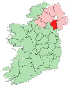
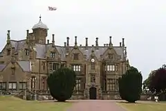
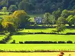
County Armagh covers 1,254 square kilometres (484 sq mi), and has a population of around 160,000. The County has 30 Grade A listed buildings, of which 25 are within the city of Armagh.
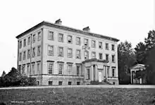
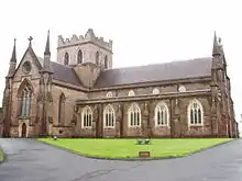
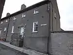
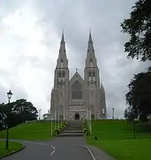
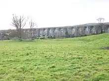
Listed buildings

.jpg.webp)
.JPG.webp)
.jpg.webp)
.jpg.webp)
%252C_November_2009.JPG.webp)
Notes
- Sometimes known as OSGB36, the grid reference is based on the British national grid reference system used by the Ordnance Survey.
- The type of structure, as identified by the DfC.
- The "HB Number" is a unique number assigned to each listed building by the DfC.
| Wikimedia Commons has media related to Grade A listed buildings in County Armagh. |
References
- "Planning Policy Statement 6: Planning, Archaeology, and the Built Heritage" (PDF). Planning Service. March 1999. p. 22. Retrieved 30 June 2010.
- "Planning Policy Statement 6 Planning, Archaeology and the Built Heritage Revised Annex C: Criteria for Listing" (.pdf). DOENI. 2011. Retrieved 8 February 2017.
- Legislation providing for the listing of buildings in England, Wales and Scotland was enacted in 1947.
- "Structure and Contents in the Historic Environment Division" (PDF). Department for Communities. December 2016. Archived from the original (PDF) on 5 January 2017. Retrieved 8 February 2017.
- "Second Survey". Department for Communities. Retrieved 8 February 2017.
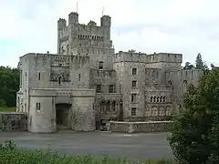
- Gosford Castle, Gosford Demesne, Markethill: Historic Building Details. Northern Ireland Buildings Database. Northern Ireland Environment Agency. Retrieved 2010-06-30.
- Richhill Castle (aka Richhill House), Richhill: Historic Building Details. Northern Ireland Buildings Database. Northern Ireland Environment Agency. Retrieved 2010-06-30.
- Court House, The Mall, Armagh: Historic Building Details. Northern Ireland Buildings Database. Northern Ireland Environment Agency. Retrieved 2010-06-30.
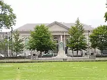
- Armagh Observatory, College Hill, Armagh: Historic Building Details. Northern Ireland Buildings Database. Northern Ireland Environment Agency. Retrieved 2010-06-30.
- 1 Charlemont Place, The Mall East, Armagh: Historic Building Details. Northern Ireland Buildings Database. Northern Ireland Environment Agency. Retrieved 2018-05-26.
- 2 Charlemont Place, The Mall East, Armagh: Historic Building Details. Northern Ireland Buildings Database. Northern Ireland Environment Agency. Retrieved 2018-05-26.
- 3 Charlemont Place, The Mall East, Armagh: Historic Building Details. Northern Ireland Buildings Database. Northern Ireland Environment Agency. Retrieved 2018-05-26.
- 4 Charlemont Place, The Mall East, Armagh: Historic Building Details. Northern Ireland Buildings Database. Northern Ireland Environment Agency. Retrieved 2018-05-26.
- 5 Charlemont Place, The Mall East, Armagh: Historic Building Details. Northern Ireland Buildings Database. Northern Ireland Environment Agency. Retrieved 2018-05-26.
- Portico front of Armagh County Museum, The Mall East, Armagh: Historic Building Details. Northern Ireland Buildings Database. Northern Ireland Environment Agency. Retrieved 2010-06-30.
- Bank Of Ireland, 36 Scotch Street, Armagh: Historic Building Details. Northern Ireland Buildings Database. Northern Ireland Environment Agency. Retrieved 2010-06-30.
- The Bishop's Palace, Armagh: Historic Building Details. Northern Ireland Buildings Database. Northern Ireland Environment Agency. Retrieved 2010-06-30.
- Primate's Chapel, Armagh: Historic Building Details. Northern Ireland Buildings Database. Northern Ireland Environment Agency. Retrieved 2018-05-26.
- Cathedral Church of St. Patrick (Church of Ireland), Armagh: Historic Building Details. Northern Ireland Buildings Database. Northern Ireland Environment Agency. Retrieved 2010-06-30.
- 1 Vicar's Hill, Armagh: Historic Building Details. Northern Ireland Buildings Database. Northern Ireland Environment Agency. Retrieved 2010-06-30.
- 2 Vicar's Hill, Armagh: Historic Building Details. Northern Ireland Buildings Database. Northern Ireland Environment Agency. Retrieved 2010-06-30.
- 3 Vicar's Hill, Armagh: Historic Building Details. Northern Ireland Buildings Database. Northern Ireland Environment Agency. Retrieved 2010-06-30.
- 4 Vicar's Hill, Armagh: Historic Building Details. Northern Ireland Buildings Database. Northern Ireland Environment Agency. Retrieved 2010-06-30.
- 5 Vicar's Hill, Armagh: Historic Building Details. Northern Ireland Buildings Database. Northern Ireland Environment Agency. Retrieved 2010-06-30.
- 6 Vicar's Hill, Armagh: Historic Building Details. Northern Ireland Buildings Database. Northern Ireland Environment Agency. Retrieved 2010-06-30.
- 7 Vicar's Hill, Armagh: Historic Building Details. Northern Ireland Buildings Database. Northern Ireland Environment Agency. Retrieved 2010-06-30.
- 8 Vicar's Hill, Armagh: Historic Building Details. Northern Ireland Buildings Database. Northern Ireland Environment Agency. Retrieved 2010-06-30.
- 9 Vicar's Hill, Armagh: Historic Building Details. Northern Ireland Buildings Database. Northern Ireland Environment Agency. Retrieved 2010-06-30.
- 10 Vicar's Hill, Armagh: Historic Building Details. Northern Ireland Buildings Database. Northern Ireland Environment Agency. Retrieved 2010-06-30.
- 11 Vicar's Hill, Armagh: Historic Building Details. Northern Ireland Buildings Database. Northern Ireland Environment Agency. Retrieved 2010-06-30.
- Public Library, Abbey Street, Armagh: Historic Building Details. Northern Ireland Buildings Database. Northern Ireland Environment Agency. Retrieved 2010-06-30.
- St. Patrick's R C Cathedral, Cathedral Road, Armagh: Historic Building Details. Northern Ireland Buildings Database. Northern Ireland Environment Agency. Retrieved 2010-06-30.
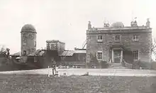
- Brownlow House, Windsor Avenue, Lurgan: Historic Building Details. Northern Ireland Buildings Database. Northern Ireland Environment Agency. Retrieved 2010-06-30.
- Killevy Castle, Ballintemple Road, Meigh, Killeavy Newry BT35 8LQ: Historic Building Details. Northern Ireland Buildings Database. Northern Ireland Environment Agency. Retrieved 2010-06-30.
- Craigmore Viaduct, Bessbrook: Historic Building Details. Northern Ireland Buildings Database. Northern Ireland Environment Agency. Retrieved 2010-06-30.