List of Monuments of National Importance in Gujarat
This is a list of Monuments of National Importance (ASI) as officially recognized by and available through the website of the Archaeological Survey of India in the Indian state Gujarat.[1] The monument identifier is a combination of the abbreviation of the subdivision of the list (state, ASI circle) and the numbering as published on the website of the ASI. 203 Monuments of National Importance have been recognized by the ASI in Gujarat.[2]
List of monuments of national importance
For technical reasons the monuments in Ahmedabad are displayed in a separate list. Please see the Ahmedabad page (N-GJ-1 to N-GJ-65) for that list.
| SL. No. | Description | Location | Address | District | Coordinates | Image |
|---|---|---|---|---|---|---|
| N-GJ-66 | Ancient site Gohilwad Timbo (Mound) | Amreli | Amreli | 21°37′N 71°12′E | 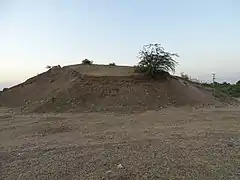 Ancient site Gohilwad Timbo (Mound) More images | |
| N-GJ-67 | Fresco on the wall of Kashiviswanath temple | Padar Singha | Amreli | 21°39′42″N 71°30′55″E | 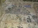 Fresco on the wall of Kashiviswanath temple More images | |
| N-GJ-68 | Ancient Site | Venivadar | Amreli | 21°38′44″N 71°08′59″E | 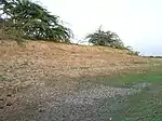 Ancient Site More images | |
| N-GJ-69 | Borsad Stepwell | Borsad | Anand | 22°24′40″N 72°54′04″E | More images | |
| N-GJ-70 | Jami Masjid, Khambhat | Khambhat | Anand | 22°18′36″N 72°37′04″E | ||
| N-GJ-71 | Ancient site / Mound | Sihor | Bhavnagar | 21°42′22″N 71°57′54″E |  | |
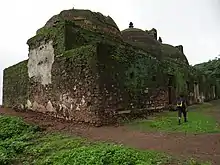
| N-GJ-72 | Darbargadh | Sihor | Bhavnagar | 21°42′39″N 71°58′00″E | | |
| N-GJ-73 | Ancient site / Mound | Vala (Vallabhi) | Bhavnagar | 21°53′38″N 71°52′28″E | | |
| N-GJ-74 | Jain temples | Talaja | Bhavnagar | 21°21′27″N 72°01′36″E |  Jain temples More images | |
| N-GJ-75 | Talaja Caves | Talaja | Bhavnagar | 21°21′N 72°02′E | More images | |
| N-GJ-76 | Jami Masjid | Bharuch | Bharuch | 21°41′31″N 72°58′55″E | 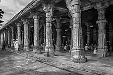 Jami Masjid | |
| N-GJ-77 | Old Ruined temple of Mahadev | Bavka | Dahod | 22°45′08″N 74°12′04″E | More images | |
| N-GJ-78 | Tomb of Sikandar Shah | Halol | Panchmahal | 22°30′19″N 73°28′23″E | ||
| N-GJ-79 | Ek-Minar-ki-Masjid | Halol | Panchmahal | 22°29′22″N 73°30′54″E | 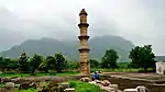 Ek-Minar-ki-Masjid More images | |
| N-GJ-80 | Panch-Mahuda-ki-Masjid | Halol | Sultanpura | Panchmahal | 22°29′24″N 73°30′01″E | 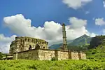 Panch-Mahuda-ki-Masjid More images |
| N-GJ-81 | Tomb near Panch Mahuda Ki Masjid | Halol | Sultanpura | Panchmahal | 22°29′39″N 73°30′01″E | |
| N-GJ-82 | Helical Stepped well (With 50 feet space around at pathway 10 feet wide to nearest road) | Champaner | Panchmahal | 22°29′04″N 73°30′56″E | 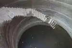 Helical Stepped well (With 50 feet space around at pathway 10 feet wide to nearest road) More images | |
| N-GJ-83 | Sakar Khan's Dargah | Champaner | Panchmahal | 22°28′58″N 73°31′06″E | 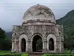 Sakar Khan's Dargah More images | |
| N-GJ-84 | City Gate | Champaner | Panchmahal | 22°28′59″N 73°31′20″E | 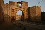 City Gate | |
| N-GJ-85 | Citadel walls | Champaner | Panchmahal | 22°29′00″N 73°31′52″E | 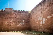 Citadel walls | |
| N-GJ-86 | City walls at S.E. corner of the citadel going up the hill | Champaner | Panchmahal | 22°29′00″N 73°32′13″E | 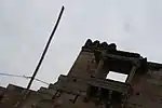 City walls at S.E. corner of the citadel going up the hill | |
| N-GJ-87 | East and South Bhadra Gates 22.484898°N 73.536494°E | Champaner | Panchmahal | 22°29′00″N 73°31′57″E | 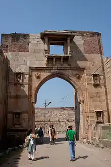 East and South Bhadra Gates 22.484898°N 73.536494°E | |
| N-GJ-88 | Sahar ki Masjid (Bohrani) | Champaner | Panchmahal | 22°29′01″N 73°31′46″E | 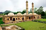 Sahar ki Masjid (Bohrani) More images | |
| N-GJ-89 | Three cells | Champaner | Panchmahal | 22°29′04″N 73°31′52″E | | |
| N-GJ-90 | Mandvi or Custom House | Champaner | Panchmahal | 22°29′03″N 73°31′54″E | 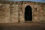 Mandvi or Custom House More images | |
| N-GJ-91 | Jami Masjid | Champaner | Panchmahal | 22°29′09″N 73°32′06″E | 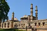 Jami Masjid More images | |
| N-GJ-92 | Stepwell | Champaner | Panchmahal | 22°29′11″N 73°32′15″E | Stepwell | |
| N-GJ-93 | Kevada Masjid | Champaner | Panchmahal | 22°29′22″N 73°31′53″E | 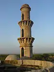 Kevada Masjid More images | |
| N-GJ-94 | Tomb with a Brick dome in the centre and small corner domes (Bada Talb ka Maqbara) | Champaner | Panchmahal | 22°29′41″N 73°33′01″E | | |
| N-GJ-95 | Canatoph of Kevda Masjid | Champaner | Panchmahal | 22°29′26″N 73°32′03″E |  Canatoph of Kevda Masjid | |
| N-GJ-96 | Nagina Masjid | Champaner | Panchmahal | 22°29′39″N 73°31′45″E | More images | |
| N-GJ-97 | Cenatop of Nagina Masjid | Champaner | Panchmahal | 22°29′39″N 73°31′49″E | 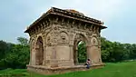 Cenatop of Nagina Masjid | |
| N-GJ-98 | Lila Gumbaj ki Masjid | Champaner | Panchmahal | 22°29′22″N 73°32′29″E | 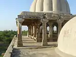 Lila Gumbaj ki Masjid More images | |
| N-GJ-99 | Kabutarkhana Pavilion (Khajuri Masjid) | Champaner | Panchmahal | 22°29′39″N 73°33′22″E |  Kabutarkhana Pavilion (Khajuri Masjid) More images | |
| N-GJ-100 | Kamani Masjid | Champaner | Panchmahal | 22°28′59″N 73°32′42″E | 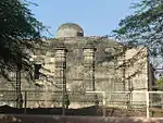 Kamani Masjid More images | |
| N-GJ-101 | Bawa Man's Mosque | Champaner | Panchmahal | 22°28′45″N 73°32′01″E | More images | |
| N-GJ-102 | Gate No. 1 Atak Gate (with two gateways) | Pavagad hill | Panchmahal | 22°28′35″N 73°31′51″E | .JPG.webp) Gate No. 1 Atak Gate (with two gateways) | |
| N-GJ-103 | Gate No. 2 (with three gateways) Budhiya gate | Pavagad hill | Panchmahal | 22°27′55″N 73°31′19″E | | |
| N-GJ-104 | Gate No. 3 Moti gate Sadanshah-Gate | Pavagad hill | Panchmahal | 22°27′41″N 73°31′40″E | 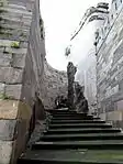 Gate No. 3 Moti gate Sadanshah-Gate | |
| N-GJ-105 | Gate No. 4 with big bastion with cells in the interior. | Pavagad hill | Panchmahal | 22°28′03″N 73°30′55″E | 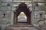 Gate No. 4 with big bastion with cells in the interior. | |
| N-GJ-106 | Sat Manzil with steps right up to bastions | Pavagad hill | Panchmahal | 22°27′44″N 73°30′59″E | 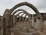 Sat Manzil with steps right up to bastions More images | |
| N-GJ-107 | Mint above Gate No. 4 | Pavagad hill | Panchmahal | 22°28′14″N 73°31′26″E | | |
| N-GJ-108 | Gate No. 5 Gulan Bulan Gate | Pavagad hill | Panchmahal | 22°28′05″N 73°31′24″E | | |
| N-GJ-109 | Gate No. 6 Buland Darwaja | Pavagad hill | Panchmahal | 22°27′55″N 73°31′14″E | | |
| N-GJ-110 | Makai Kothar | Pavagad hill | Panchmahal | 22°27′55″N 73°31′14″E | | |
| N-GJ-111 | Patai Rawal's Palace with tanks | Pavagad hill | Panchmahal | 22°27′42″N 73°31′39″E | _Palace%252C_Pavagadh.JPG.webp) Patai Rawal's Palace with tanks | |
| N-GJ-112 | Gate No. 7 Makai Gate | Pavagad hill | Panchmahal | 22°27′56″N 73°31′10″E | | |
| N-GJ-113 | Gate No. 8 Tarapore Gate | Pavagad hill | Panchmahal | 22°28′03″N 73°30′56″E | | |
| N-GJ-114 | Fort of Pavagad & ruined Hindu temples & Jain temples on the top of Pavagad hills | Pavagad hill | Panchmahal | 22°28′01″N 73°30′55″E | 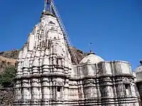 Fort of Pavagad & ruined Hindu temples & Jain temples on the top of Pavagad hills | |
| N-GJ-115 | Navlakha Kothar | Pavagad hill | Panchmahal | 22°28′02″N 73°30′34″E | 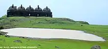 Navlakha Kothar | |
| N-GJ-116 | Walls of fort on top | Pavagad hill | Panchmahal | 22°27′49″N 73°31′06″E | | |
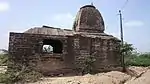
| N-GJ-117 | Rudra Mahalaya temple | Desar | Panchmahal | 22°21′02″N 73°33′07″E | | |
| N-GJ-118 | Kankeshvara Mahadev temple | Kakanpur | Panchmahal | 22°49′56″N 73°29′03″E | | |
| N-GJ-119 | Ratnesvara Old temple with sculptures screen | Ratanpur | Panchmahal | 22°50′22″N 73°25′55″E | | |
| N-GJ-120 | Rudabai stepwell or Adalaj Stepwell | Adalaj | Gandhinagar | 23°10′N 72°35′E | 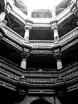 Rudabai stepwell or Adalaj Stepwell More images | |
| N-GJ-121 | Durvasa Rishi's Ashram & its site (Pindara Group of Temples) | Pindara | Devbhoomi Dwarka | 22°15′52″N 69°15′10″E | 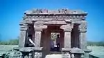 Durvasa Rishi's Ashram & its site (Pindara Group of Temples) More images | |
| N-GJ-122 | Kalika Mata Temple | Old Dhrewad | Jamnagar | 22°08′58″N 69°04′22″E | More images | |
| N-GJ-123 | Gokeshwara Mahadev temple | Lowrali | Jamnagar | 22°10′26″N 69°05′31″E | | |
| N-GJ-124 | Gandhi fortress & temple in Survey no.106 | Old Dhink | Jamnagar | 22°12′28″N 69°04′49″E | | |
| N-GJ-125 | Temples of Rama Lakshamana | Baradia | Devbhumi Dwarka | 22°11′44″N 69°01′09″E | More images | |
| N-GJ-126 | Dwarkadhish Group of Temples with its outer compounds SNO. 1607, 1608, 1609. | Dwarka | Devbhumi Dwarka | 22°14′17″N 68°58′02″E | 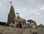 Dwarkadhish Group of Temples with its outer compounds SNO. 1607, 1608, 1609. More images | |
| N-GJ-127 | Kshatrapa Inscriptions | Dwarka | Devbhumi Dwarka | 22°14′N 68°58′E | | |
| N-GJ-128 | Rukmini Devi Temple | Dwarka | Devbhumi Dwarka | 22°15′27″N 68°57′52″E | More images | |
| N-GJ-129 | Dhrasanvel Temple (Magderu) | Dhrasanvel | Devbhoomi Dwarka | 22°17′21″N 69°03′05″E | .jpg.webp) Dhrasanvel Temple (Magderu) More images | |
| N-GJ-130 | Guhaditya temple in S.No. 655 | Varvada | Jamnagar | 22°18′04″N 68°59′13″E | | |
| N-GJ-131 | Junagadhi (Jain) Temple | Vasai | Jamnagar | 22°19′05″N 68°59′57″E | | |
| N-GJ-132 | Kankeshvara Mahadeva temple & other shrines | Vasai | Jamnagar | 22°19′06″N 68°59′50″E | | |
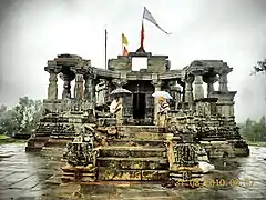
| N-GJ-133 | Gop Temple | Nani Gop | Jamnagar | 22°01′43″N 69°55′44″E | More images | |
| N-GJ-134 | Ashokan Rock (Edicts) | Junagadh | Junagadh | 21°31′33″N 70°28′59″E |  Ashokan Rock (Edicts) More images | |
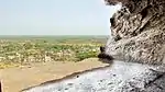
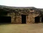
| N-GJ-135 | Uparkot Caves (Buddhist Cave) of Junagadh Buddhist Cave Groups | Junagadh | Junagadh | 21°31′33″N 70°28′09″E |  Uparkot Caves (Buddhist Cave) of Junagadh Buddhist Cave Groups More images | |
| N-GJ-136 | Baba Pyare and Khapra Kodia caves of Junagadh Buddhist Cave Groups | Junagadh | Junagadh | 21°31′12″N 70°28′05″E | 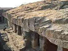 Baba Pyare and Khapra Kodia caves of Junagadh Buddhist Cave Groups More images | |
| N-GJ-137 | Ancient Mound | Intwa | Junagadh | 21°33′06″N 70°29′30″E | 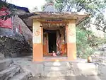 Ancient Mound More images | |
| N-GJ-138 | Jami Masjid | Mangrol | Junagadh | 21°07′10″N 70°06′38″E | | |
| N-GJ-139 | Bibi Masjid | Mangrol | Junagadh | 21°07′18″N 70°06′52″E | | |
| N-GJ-140 | Raveli Masjid | Mangrol | Junagadh | 21°07′18″N 70°06′46″E | | |
| N-GJ-141 | Ranchhod Rayaji Temple with wasterland around the chowk of Mahadeva Temple | Mul Dwarka | Junagadh | 20°45′34″N 70°39′40″E | 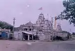 Ranchhod Rayaji Temple with wasterland around the chowk of Mahadeva Temple More images | |
| N-GJ-142 | Vithalbhai Haveli | Vasco | Kheda | 22°39′40″N 72°45′21″E | | |
| N-GJ-143 | Bhamaria Well | Mahamadabad | Kheda | 22°48′42″N 72°44′57″E | 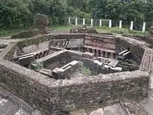 Bhamaria Well | |
| N-GJ-144 | Temple of Galteshwar | Sarnal | Kheda | 22°47′06″N 73°16′39″E | More images | |
| N-GJ-145 | Tomb of Saif-ud-din & Nizam-ud-din | Sojali | Kheda | 22°50′30″N 72°46′20″E | | |
| N-GJ-146 | Tomb of Mubarak Saiyyad (Roza Rozi Dargah Sharif) | Sojali | Kheda | 22°50′33″N 72°46′20″E | 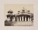 Tomb of Mubarak Saiyyad (Roza Rozi Dargah Sharif) | |
| N-GJ-147 | Rao Lakhpatji Chhatri | Bhuj | Kachchh | 23°14′47″N 69°39′28″E | 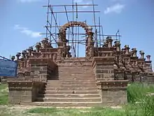 Rao Lakhpatji Chhatri More images | |
| N-GJ-148 | Siva temple | Kotai | Kachchh | 23°23′04″N 69°46′56″E | | |
| N-GJ-149 | Excavated Site (Surkotada) | Surkotada | Kachchh | 23°53′12″N 70°12′24″E | | |
| N-GJ-150 | Malai Mata temple | Palodar | Mehsana | 23°38′28″N 72°21′38″E | _of_Malai_Mata_temple%252C_Palodar%252C_Gujarat%252C_India.jpg.webp) Malai Mata temple More images | |
| N-GJ-151 | Hingloji Mata temple (Hinglaj Mata) | Khandosan | Mehsana | 23°44′14″N 72°28′23″E | | |
| N-GJ-152 | Sabha Mandapa (Double Shrines) & the ancient shrines (Panchmukhi Mahadev temple) | Khandosan | Mehsana | 23°44′14″N 72°28′26″E | | |
| N-GJ-153 | Jasmalnathji Mahadev Temple (Vaijnath Mahadev temple) | Asoda | Mehsana | 23°35′00″N 72°35′23″E | 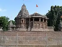 Jasmalnathji Mahadev Temple (Vaijnath Mahadev temple) More images | |
| N-GJ-154 | Ajpal Kund (Gauri Kund) | Vadnagar | Mehsana | 23°46′58″N 72°38′54″E | | |
| N-GJ-155 | Inscription and Arjun Bari Gate | Vadnagar | Mehsana | 23°47′18″N 72°38′21″E | 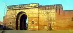 Inscription and Arjun Bari Gate More images | |
| N-GJ-156 | Kirti Toran | Vadnagar | Mehsana | 23°47′27″N 72°38′32″E | 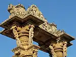 Kirti Toran More images | |
| N-GJ-157 | Kund | Vijapur | Mehsana | 23°33′52″N 72°45′27″E | | |
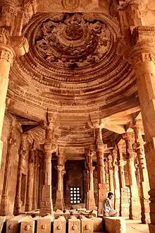
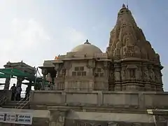
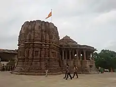
| N-GJ-158 | Sun temple, Surya kund with adjoining other temples and loose sculptures | Modhera | Mehsana | 23°35′02″N 72°07′58″E | More images | |
| N-GJ-159 | Gateway of Khan Sarovar | Patan | Patan | 23°50′22″N 72°06′55″E | | |
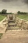
| N-GJ-160 | Rani ki vav | Patan | Patan | 23°51′31″N 72°06′03″E | More images | |
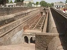
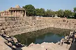
| N-GJ-161 | Sahastralinga Tank (Excavated) | Anavada | Patan | 23°51′45″N 72°05′52″E | 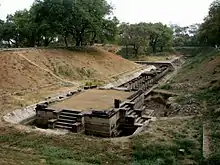 Sahastralinga Tank (Excavated) More images | |
| N-GJ-162 | Shaikh Farid Tomb | Patan | Patan | 23°51′59″N 72°05′47″E | | |
| N-GJ-163 | Jami Masjid | Sidhpur | Patan | 23°55′10″N 72°22′44″E | | |
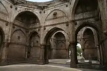
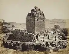
| N-GJ-164 | Ruins of Rudra Mahalaya Temple, Sidhpur | Sidhpur | Patan | 23°55′10″N 72°22′37″E | 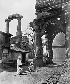 Ruins of Rudra Mahalaya Temple, Sidhpur More images | |
| N-GJ-165 | Nilkantheswar Mahadev temple | Sunak | Patan | 23°48′10″N 72°19′03″E | 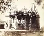 Nilkantheswar Mahadev temple | |
| N-GJ-166 | Sivai Mata temple | Sunak | Patan | 23°48′11″N 72°18′59″E | | |
| N-GJ-167 | Nilkantheswar Mahadev temple | Ruhavi | Patan | 23°46′09″N 72°18′02″E | | |
| N-GJ-168 | Two small shrines Sanderi Mata temple | Sander | Patan | 23°46′04″N 72°15′33″E | 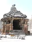 Two small shrines Sanderi Mata temple More images | |
| N-GJ-169 | Sitamata temple | Piludra | Patan | 23°39′54″N 72°25′55″E | | |
| N-GJ-170 | Torana with a Sun image | Piludra | Patan | 23°39′50″N 72°25′54″E | | |
| N-GJ-171 | Limboji Mata temple | Delmal | Patan | 23°38′35″N 71°59′31″E | 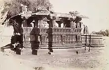 Limboji Mata temple | |
| N-GJ-172 | Kirti Mandir, Porbandar (House where Mahatma Gandhi was born) | Porbandar | Porbandar | 21°38′28″N 69°36′02″E | 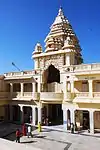 Kirti Mandir, Porbandar (House where Mahatma Gandhi was born) | |
| N-GJ-173 | Old Parsvanath temple | Miyani | Porbandar | 21°50′23″N 69°22′56″E | | |
| N-GJ-174 | Dhank Caves | Dhank | Rajkot | 21°50′02″N 70°04′59″E | More images | |
| N-GJ-175 | Tomb of Sikandarshah | Prantji | Sabarkanta | 23°26′08″N 72°51′28″E | | |
| N-GJ-176 | Roda Group of Temples | Khed & Roda | Sabarkanta | 23°39′33″N 73°04′59″E | More images | |
| N-GJ-177 | Dargah known as Khawaja Dana Saheb's Rouza | Surat | Surat | 21°11′28″N 72°49′16″E | 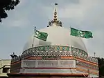 Dargah known as Khawaja Dana Saheb's Rouza | |
| N-GJ-178 | Old English Tombs | Surat | Surat | 21°12′39″N 72°49′33″E | 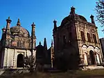 Old English Tombs More images | |
| N-GJ-179 | Tomb of Khawaja Safar Sulemani (Khudawand Khan Rojo) | Surat | Surat | 21°12′15″N 72°49′25″E | 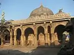 Tomb of Khawaja Safar Sulemani (Khudawand Khan Rojo) | |
| N-GJ-180 | Old Dutch & Armenian Tombs & Cemeteries | Surat | Surat | 21°12′35″N 72°49′35″E | 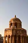 Old Dutch & Armenian Tombs & Cemeteries More images | |
| N-GJ-181 | Ancient site comprising S.Plot No.535 | Kamrej | Surat | 21°16′57″N 72°58′02″E | | |
| N-GJ-182 | Fateh Burj | Vyara | Surat | 21°06′52″N 73°23′42″E | | |
| N-GJ-183 | Ranak Devi's Temple | Wadhwan | Surendranagar | 22°42′49″N 71°40′34″E |  Ranak Devi's Temple More images | |
| N-GJ-184 | Ancient Mound (Rangpur, Gujarat) | Rangpur | Surendranagar | 22°24′02″N 71°55′43″E | | |
| N-GJ-185 | Sun Temple | Thangadh | Surendranagar | 22°35′50″N 71°12′53″E |  Sun Temple | |
| N-GJ-186 | Navlakha temple | Sejakpur | Surendranagar | 22°27′26″N 71°24′45″E | 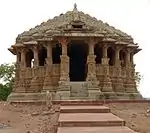 Navlakha temple | |
| N-GJ-187 | Ancient Site/Mound (Ganesh temple) in village | Sejakpur | Surendranagar | 22°27′25″N 71°24′52″E | | |
| N-GJ-188 | Darbargarh | Halwad | Surendranagar | 23°00′42″N 71°10′43″E | | |
| N-GJ-189 | Ananteshwara temple | Bhadia Anandpur | Surendranagar | 22°13′28″N 71°10′03″E | | |
| N-GJ-190 | Fresco Rooms in Bhau Tambekar's Wada | Vadodara | Vadodara | 22°18′10″N 73°11′49″E | 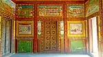 Fresco Rooms in Bhau Tambekar's Wada More images | |
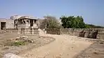
| N-GJ-191 | Historic Site S.No. 431,435 | Vadodara | Vadodara | 22°18′03″N 73°10′52″E |  Historic Site S.No. 431,435 | |
| N-GJ-192 | Hazira or Qutbuddin Mahmad Khan's Tomb (Hazira Maqbara) | Danteshwar | Vadodara | 22°16′41″N 73°12′24″E | 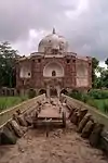 Hazira or Qutbuddin Mahmad Khan's Tomb (Hazira Maqbara) More images | |
| N-GJ-193 | Ancient Site (Excavated) at Kayavarohan | Kayavarohan | Vadodara | 22°04′52″N 73°14′59″E | 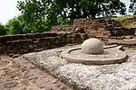 Ancient Site (Excavated) at Kayavarohan More images | |
| N-GJ-194 | Gateway of Torana | Kayavarohan | Vadodara | 22°04′57″N 73°14′52″E | _(9).jpg.webp) Gateway of Torana More images | |
| N-GJ-195 | Ancient site of Sandhiyapura | Goraj | Vadodara | 22°19′54″N 73°28′35″E | | |
| N-GJ-196 | Vadodara Gate & its adjacent construction | Dabhoi | Vadodara | 22°08′04″N 73°24′56″E | 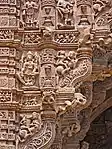 Vadodara Gate & its adjacent construction More images | |
| N-GJ-197 | Hira Gate with S.No. 38, 41, 45, 47 & Ticca No. 102&103. | Dabhoi | Vadodara | 22°08′01″N 73°25′28″E | 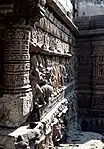 Hira Gate with S.No. 38, 41, 45, 47 & Ticca No. 102&103. More images | |
| N-GJ-198 | Mahudi (Champaneri) Gate & adjacent construction | Dabhoi | Vadodara | 22°08′16″N 73°25′07″E | | |
| N-GJ-199 | Nandodi Gate with adjacent construction | Dabhoi | Vadodara | 22°07′47″N 73°25′13″E | 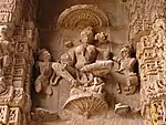 Nandodi Gate with adjacent construction More images | |
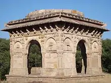
| N-GJ-200 | Saptamukhi Vav | Dabhoi | Vadodara | 22°08′07″N 73°25′19″E | 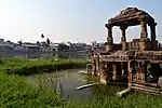 Saptamukhi Vav More images | |
| N-GJ-201 | Microlithic site S.No. 311,12,13 & 298 | Amarapura | Vadodara | 22°40′36″N 73°16′17″E | | |
| N-GJ-202 | Dholavira (Ancient Site (Kotada)) | Dholavira | Bhachau Taluka | Kutch | 23°53′10″N 70°13′00″E |  Dholavira (Ancient Site (Kotada)) More images |
| N-GJ-203 | Archeological Site and Remains | Juni Kuran, Bhuj | Bhuj Taluka | Kutch | 23°56′47″N 69°46′01″E | |

See also
- List of Monuments of National Importance in India for other Monuments of National Importance in India
- List of State Protected Monuments in Gujarat
References
- List of Monuments of National Importance as published by the Archaeological Survey of India Archived 2014-06-27 at the Wayback Machine.
- "List of Ancient Monuments and Archaeological Sites and Remains of Gujarat - Archaeological Survey of India". asi.nic.in. Retrieved 2016-11-18.
External links
- Heritage sites and Monuments on ISRO Geoportal Bhuvan for coordinates
- Monuments - Vadodara Circle, ASI
| Wikimedia Commons has media related to Cultural heritage monuments in Gujarat. |
This article is issued from Wikipedia. The text is licensed under Creative Commons - Attribution - Sharealike. Additional terms may apply for the media files.