List of Places of Scenic Beauty of Japan (Okinawa)
National Places of Scenic Beauty
As of 1 June 2019, fourteen Places have been designated at a national level (including one *Special Place of Scenic Beauty).[2][3][4]
| Place | Municipality | Comments | Image | Coordinates | Type | Ref. |
|---|---|---|---|---|---|---|
| *Shikina-en 識名園 Shikina-en | Naha | inscribed on the UNESCO World Heritage List as one of the Gusuku Sites and Related Properties of the Kingdom of Ryukyu[5] | 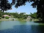 | 26°12′16″N 127°42′55″E | 1 | |
| Ieudun Detached Residence Gardens 伊江御殿別邸庭園 Ieudun bettei teien | Naha | 26°13′38″N 127°43′29″E | 1 | |||
| Iedunchi Gardens 伊江殿内庭園 Iedunchi teien | Naha | 26°13′12″N 127°43′17″E | 1 | |||
| Shimojishima Tōri-ike 下地島の通り池 Shimojishima Tōri-ike | Miyakojima | also a Natural Monument | 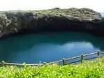 | 24°49′30″N 125°08′15″E | 5, 8 | |
| Kiyan Coast and Arasaki Coast 喜屋武海岸及び荒崎海岸 Kiyan kaigan oyobi Arasaki kaigan | Itoman | also a Natural Monument | 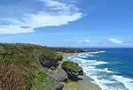 | 26°07′48″N 127°39′55″E | 8 | |
| Miyaradunchi Gardens 宮良殿内庭園 Miyaradunchi teien | Ishigaki | 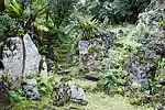 | 24°20′28″N 124°09′35″E | 1 | ||
| Shuri Castle Shoin - Sasunoma Gardens 首里城書院・鎖之間庭園 Shuri-jō shoin・Sasunoma teien | Naha | inscribed on the UNESCO World Heritage List as one of the Gusuku Sites and Related Properties of the Kingdom of Ryukyu[5] | 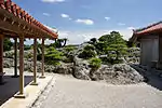 | 26°12′59″N 127°43′09″E | 1 | |
| Ishigaki Family Gardens 石垣氏庭園 Ishigaki-shi teien | Ishigaki | 24°20′41″N 124°09′20″E | 1 | |||
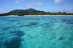
| Kabira Bay - Mount Omoto 川平湾及び於茂登岳 Kabira-wan oyobi Omoto-dake | Ishigaki | 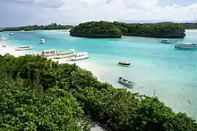 | 24°27′07″N 124°08′34″E | 8, 10, 11 | ||
| Cape Higashi-Henna 東平安名崎 Higashihenna-zaki | Miyakojima | 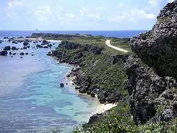 | 24°43′31″N 125°27′38″E | 8 | ||
| Yabiji 八重干瀬 Yabiji | Miyakojima | also a Natural Monument | 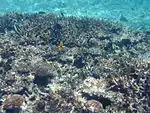 | 24°59′56″N 125°15′53″E | 8 | |
| Tindabana ティンダバナ Tindabana | Yonaguni | 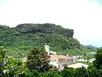 | 24°28′00″N 123°00′10″E | 5 | ||
| Kubura Bali - Kubira Furishi 久部良バリ及び久部良フリシ Kubura Bali oyobi Kubira Furishi | Yonaguni | 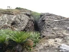 | 24°28′00″N 123°00′10″E | 8 | ||
| Amamiku-no-mori - Tenchiji-Amachiji - Kuba-no-utaki - Kudaka-no-Fubō-utaki アマミクヌムイ(アマミクの杜)今鬼神ノカナヒヤフ(テンチジアマチジ)及びこはおの御嶽(クバの御嶽) 久高コハウ森(久高のフボー御嶽) Amamiku-nu-mui (Amamiku-no-mori) Nakijin-no-kanahiyafu (Tenchiji Amachiji) oyobi Kohao-no-utaki (Kuba no utaki) Kudaka Kohau-mui (Kudaka-no-Fubō utaki) | Nakijin, Nanjō | 26°40′57″N 127°58′22″E | 8 | |||
Prefectural Places of Scenic Beauty
As of 1 May 2018, nine Places have been designated at a prefectural level.[4][6]
| Place | Municipality | Comments | Image | Coordinates | Type | Ref. |
|---|---|---|---|---|---|---|
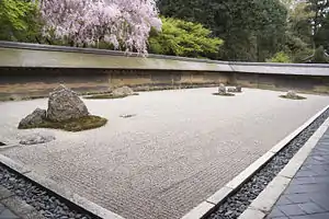
| Sefa-utaki 斎場御嶽 Sefa-utaki | Nanjō | also an Historic Site; inscribed on the UNESCO World Heritage List as one of the Gusuku Sites and Related Properties of the Kingdom of Ryukyu[5] | .jpg.webp) | 26°10′24″N 127°49′36″E | for all refs see | |
| Nakagusuku Castle Site 中城城跡 Nakagusuku-jō ato | Nakagusuku | also an Historic Site | 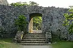 | 26°17′02″N 127°48′05″E | ||
| Nakijin Castle Site 今帰仁城跡 Nakijin-jō ato | Nakijin | also an Historic Site | 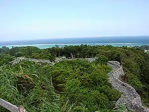 | 26°41′27″N 127°55′49″E | ||
| Todoroki Falls 轟の滝 Todoroki no taki | Nago | 26°33′45″N 127°59′18″E | ||||
| Shurikinjō-chō Ishidatami-michi 首里金城町石畳道 Shurikinjō-chō ishidatami-michi | Naha | also a Prefectural Historic Site | 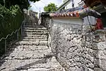 | 26°12′58″N 127°42′55″E | ||
| Ie Village Mount Gusuku 伊江村の城山 Ie-mura no Gusuku-yama | Ie | 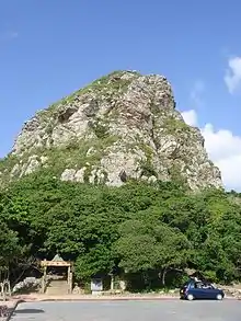 | 26°43′10″N 127°48′25″E | |||
| Ginowan City Mori River 宜野湾市森の川 Ginowan-shi Mori-no-kawa | Ginowan | 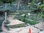 | 26°16′17″N 127°44′30″E | |||
| Cape Manza 万座毛 Manza-mō | Onna | 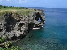 | 26°30′18″N 127°51′01″E | |||
| Sanninudai サンニヌ台 Sanninudai | Yonaguni | 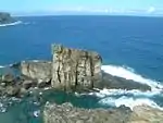 | 24°27′14″N 123°02′00″E | |||
Municipal Places of Scenic Beauty
As of 1 May 2018, a further twenty Places have been designated at a municipal level.[4][7]
| Place | Municipality | Comments | Image | Coordinates | Type | Ref. |
|---|---|---|---|---|---|---|
| Teniya Ban Sachi Beacon Site 天仁屋バンサチの火立跡 Teniya ban sachi no hitachi ato | Nago | also a Municipal Historic Site | 26°33′13″N 128°08′17″E | for all refs see | ||
| Waji ワシ (also 湧出 or わじぃー) Wajī | Ie | _Okinawa%252CJAPAN.jpg.webp) | 26°43′59″N 127°47′22″E | |||
| Innagā 犬名河(インナガー) Innagā | Uruma | on Ikei Island (伊計島) | 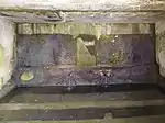 | 26°23′44″N 127°59′40″E | ||
| Futenma-gū Cave 普天満宮洞穴 Futenma-gū dōketsu | Ginowan | 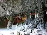 | 26°17′35″N 127°46′39″E | |||
| Naminoue 波上 Naminoue | Naha | also a Municipal Historic Site | 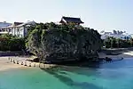 | 26°13′14″N 127°40′17″E | ||
| Garner-Mui Forest ガーナー森 Gānā-mui | Naha | also a Natural Monument | 26°12′03″N 127°40′40″E | |||
| Hiyajō Banta 比屋定バンタ Hiyajō banta | Kumejima | 26°22′24″N 126°47′23″E | ||||
| Aka-no-Higemizu 阿嘉のひげ水 Aka-no-higemizu | Kumejima | 26°22′00″N 126°47′44″E | ||||
| Aka-Kurushi 阿嘉黒石 Aka kurushi | Kumejima | 26°22′10″N 126°48′12″E | ||||
| Ueda Forest 上田森 Ueda-mori | Kumejima | 26°21′37″N 126°44′58″E | ||||
| Tokujimu Coast and Andesite Zone トクジム海岸と一帯の安山岩 Tokujimu kaigan to ittai no anzangan | Kumejima | 26°17′39″N 126°48′47″E | ||||
| View of the Kerama Straits from Mount Nishi にし山(北山)山頂から望む慶良間海峡 Nishi-yama sanchō kara nozomu Kerama kaikyō | Tokashiki | 26°12′36″N 127°21′46″E | ||||
| Scenic Spots of Banyahara 番屋原の広場の景勝地 Banyahara no hiroba no keishō-chi | Aguni | 26°34′54″N 127°13′26″E | ||||
| Scenic Spots of Sakakinahara Coast 坂木那原海岸景勝地 Sakakinahara kaigan keishō-chi | Aguni | 26°34′39″N 127°13′14″E | ||||
| Nzōmiji 無蔵水 Nzōmiji | Iheya | 27°05′30″N 128°00′45″E | ||||
| Coral Reef and Lagoon at Sawada Beach 佐和田の浜珊瑚礁・礁湖面 Sawada-no-hama sangoshō・shōko-men | Miyakojima | within Irabu Prefectural Natural Park | 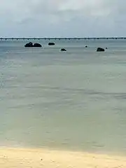 | 24°50′19″N 125°09′31″E | ||
| Rocky Coast at Cape Hakuchō 白鳥崎岩礁海岸一帯 Hakuchō-zaki ganshō kaigan ittai | Miyakojima | within Irabu Prefectural Natural Park | 27°05′30″N 128°00′45″E | |||
| Rocky Coast of West and South Shimojishima 下地島南、西岩礁海岸一帯 Shimojishima minami, nishi ganshō kaigan ittai | Miyakojima | within Irabu Prefectural Natural Park | 24°48′49″N 125°08′28″E | |||
| Scenery of Takana 高那の景勝 Takana no keishō | Taketomi | Hateruma Island | 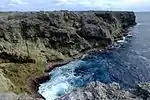 | 24°03′00″N 123°47′51″E | ||
| Ufudaki 大岳 Ufudaki | Taketomi | Kohama Island; site of one of the Sakishima Beacons | 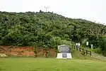 | 24°20′49″N 123°58′43″E | ||
Registered Places of Scenic Beauty
As of 1 June 2019, three Monuments have been registered (as opposed to designated) as Places of Scenic Beauty at a national level.[3][4][8]
| Place | Municipality | Comments | Image | Coordinates | Type | Ref. |
|---|---|---|---|---|---|---|
| Former Nakasone Family Gardens 旧仲宗根氏庭園 kyū-Nakasone-shi teien | Miyakojima | 24°48′21″N 125°16′50″E | ||||
| Cape Ugan 御神崎 Ugan-zaki | Ishigaki | 24°20′22″N 124°09′14″E | ||||
| Nakamoto Family Gardens 仲本氏庭園 Nakamoto-shi teien | Ishigaki | 24°20′07″N 124°08′52″E | ||||

| Tangible Cultural Properties | .jpg.webp)  | |
|---|---|---|
| Intangible Cultural Properties | ||
| Folk Cultural Properties |
| |
| Monuments | ||
| Cultural Landscapes | N/A | |
| Groups of Traditional Buildings | ||
| Conservation Techniques |
| |
1 | ||
See also
- Cultural Properties of Japan
- List of Historic Sites of Japan (Okinawa)
- List of parks and gardens of Okinawa Prefecture
- List of Natural Monuments of Japan (Okinawa)
References
- "Cultural Properties for Future Generations". Agency for Cultural Affairs. Retrieved 10 June 2019.
- 史跡名勝天然記念物 [Number of Monuments of Japan by Prefecture] (in Japanese). Agency for Cultural Affairs. 1 June 2019. Retrieved 10 June 2019.
- "Database of National Cultural Properties: 史跡名勝天然記念物 (名勝, 特別名勝 沖縄県)" (in Japanese). Agency for Cultural Affairs. Archived from the original on 2 May 2017. Retrieved 10 June 2019.
- 国・県・市町村指定文化財 [National, Prefectural, and Municipal Cultural Properties] (PDF) (in Japanese). Okinawa Prefecture. 1 May 2018. Retrieved 10 June 2019.
- "Gusuku Sites and Related Properties of the Kingdom of Ryukyu". UNESCO. Retrieved 10 June 2019.
- 都道府県別指定等文化財件数(都道府県分) [Number of Prefectural Cultural Properties by Prefecture] (in Japanese). Agency for Cultural Affairs. 1 May 2018. Retrieved 10 June 2019.
- 都道府県別指定等文化財件数(市町村分) [Number of Municipal Cultural Properties by Prefecture] (in Japanese). Agency for Cultural Affairs. 1 May 2018. Retrieved 10 June 2019.
- 登録文化財 [Number of Registered Cultural Properties by Prefecture] (in Japanese). Agency for Cultural Affairs. 1 June 2019. Retrieved 10 June 2019.
External links
- (in Japanese) Cultural Properties in Okinawa Prefecture
- (in Japanese) List of Cultural Properties in Okinawa Prefecture
This article is issued from Wikipedia. The text is licensed under Creative Commons - Attribution - Sharealike. Additional terms may apply for the media files.