List of Places of Scenic Beauty of Japan (Kumamoto)
National Places of Scenic Beauty
As of 1 July 2020, ten Places have been designated at a national level.[2][3][4]
| Site | Municipality | Comments | Image | Coordinates | Type | Ref. |
|---|---|---|---|---|---|---|
| Shōhinken Gardens 旧熊本藩八代城主浜御茶屋(松浜軒)庭園 kyū-Kumamoto-han Yatsushiro-jō-shu hama-ochaya (Shōhinken) teien | Yatsushiro |  | 32°30′34″N 130°35′47″E | 1 | ||
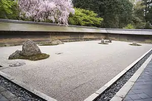
| Suizen-ji Jōju-en 水前寺成趣園 Suizenji Jōju-en | Kumamoto | also an Historic Site |  | 32°47′28″N 130°44′05″E | 1, 8 | |
| Mount Sengan and Mount Takabuto 千厳山および高舞登山 Sengan-san oyobi Takabuto-yama | Kami-Amakusa |  | 32°31′22″N 130°26′30″E | 11 | ||
| Places of Scenic Beauty in the Territory of Higo 肥後領内名勝地 Higo ryōnai meishō chi | Yamato, Yatsushiro, Hikawa, Kuma | designation comprises Gorō Falls (五郎ガ瀧, Gorō-ga-taki), Hijiri Falls (聖リ瀧, Hijiri-daki), Hashirimizu Falls (走リ水ノ瀧, Hashiri-mizu no taki), Tategami Rock (建神ノ岩, Tategami no iwa), and Kōnose-no-Iwaya (神ノ瀬ノ岩屋, Kōnose no iwaya) |  | 32°27′39″N 130°42′15″E | 5, 6 | |
| Shiranui and Mizushima 不知火及び水島 Shiranui oyobi Mizushima | Uki, Yatsushiro | 32°28′19″N 130°34′09″E | 11 | |||
| Komezuka and Kusasenrigahama 米塚及び草千里ヶ浜 Komezuka oyobi Kusasenrigahama | Aso, Minamiaso | also a Natural Monument |  | 32°53′01″N 131°03′09″E | 9 | |
| Myōken Bay 妙見浦 Myōken-ura | Amakusa | also a Natural Monument |  | 32°24′19″N 129°59′47″E | 8 | |
| Ryūgatake 龍ヶ岳 Ryūgatake | Kami-Amakusa | 32°24′17″N 130°22′47″E | 11 | |||
| Ryūsentō Island 龍仙島(片島) Ryūsentō (Katashima) | Amakusa | also a Natural Monument | 32°08′45″N 129°58′22″E | 8 | ||
| Mount Rokurōji 六郎次山 Rokurōji-yama | Amakusa | 32°16′04″N 130°05′18″E | 11 | |||
Prefectural Places of Scenic Beauty
As of 1 May 2019, two Places have been designated at a prefectural level.[4][5]
| Site | Municipality | Comments | Image | Coordinates | Type | Ref. |
|---|---|---|---|---|---|---|
| Unganzen-ji Precinct 雲巌禅寺境内 Unganzenji keidai | Kumamoto | also a Prefectural Historic Site | 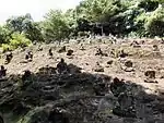 | 32°49′10″N 130°37′22″E | ||
| Mangan-ji Gardens 満願寺庭園 Manganji teien | Minamioguni | also a Prefectural Historic Site |  | 33°04′34″N 131°05′45″E | ||
Municipal Places of Scenic Beauty
As of 1 May 2019, thirty Places have been designated at a municipal level, including:[4][6]
| Site | Municipality | Comments | Image | Coordinates | Type | Ref. |
|---|---|---|---|---|---|---|
| Zuigan-ji Site 瑞巌寺跡 Zuiganji ato | Kumamoto | also a Municipal Historic Site | 32°50′52″N 130°41′17″E | |||
| Sairyū-en 栽柳園 Sairyū-en | Yatsushiro | 32°29′34″N 130°36′11″E | ||||
| Kogase 小ヶ瀬 Kogase | Amakusa | 32°19′17″N 129°57′39″E | ||||
Registered Places of Scenic Beauty
As of 1 July 2020, one Monument has been registered (as opposed to designated) as a Place of Scenic Beauty at a national level.[3][7]
| Place | Municipality | Comments | Image | Coordinates | Type | Ref. |
|---|---|---|---|---|---|---|
| Shiramizu Falls 白水の滝 Shiramizu no taki | Takamori | designation spans the borders with Taketa, Ōita | 32°52′57″N 131°16′40″E | |||


See also
- Cultural Properties of Japan
- List of parks and gardens of Kumamoto Prefecture
- List of Historic Sites of Japan (Kumamoto)
- List of Cultural Properties of Japan - paintings (Kumamoto)
External links
- (in Japanese) Cultural Properties in Kumamoto Prefecture
References
- "Cultural Properties for Future Generations". Agency for Cultural Affairs. Retrieved 20 July 2020.
- 史跡名勝天然記念物 [Number of Monuments of Japan by Prefecture] (in Japanese). Agency for Cultural Affairs. 1 July 2020. Retrieved 19 July 2020.
- "Database of National Cultural Properties: 史跡名勝天然記念物 (名勝, 特別名勝 熊本県)" (in Japanese). Agency for Cultural Affairs. Retrieved 19 July 2020.
- 文化財指定等の件数 [Number of Cultural Properties] (in Japanese). Kumamoto Prefecture. 29 September 2019. Retrieved 19 July 2020.
- 都道府県別指定等文化財件数(都道府県分) [Number of Prefectural Cultural Properties by Prefecture] (in Japanese). Agency for Cultural Affairs. 1 May 2019. Retrieved 19 July 2020.
- 都道府県別指定等文化財件数(市町村分) [Number of Municipal Cultural Properties by Prefecture] (in Japanese). Agency for Cultural Affairs. 1 May 2019. Retrieved 19 July 2020.
- 登録文化財 [Number of Registered Cultural Properties by Prefecture] (in Japanese). Agency for Cultural Affairs. 1 July 2020. Retrieved 19 July 2020.
This article is issued from Wikipedia. The text is licensed under Creative Commons - Attribution - Sharealike. Additional terms may apply for the media files.