List of airports in Tonga
This is a list of airports in Tonga, sorted by location.
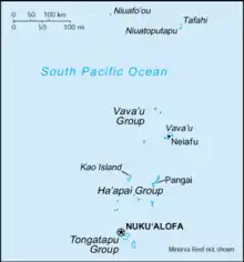
Map of Tonga
Tonga, officially the Kingdom of Tonga, is an archipelago in the South Pacific Ocean, consisting of 169 islands, 36 of them inhabited. The Kingdom stretches over a distance of about 800 kilometres (500 mi) in a north-south line. The islands that constitute the archipelago lie south of Samoa, about one-third of the way from New Zealand to Hawaiʻi.
Airports
| Location served | ICAO | IATA | Airport name | Coordinates |
|---|---|---|---|---|
| ʻEua | NFTE | EUA | ʻEua Airport (Kaufana Airport) | 21°23′S 174°57′W |
| Lifuka, Haʻapai | NFTL | HPA | Lifuka Island Airport (Salote Pilolevu Airport) | 19°46′36″S 174°20′28″W |
| Niuafoʻou | NFTO | NFO | Niuafoʻou Airport (Kuini Lavinia Airport) | 15°34′16″S 175°37′51″W |
| Niuatoputapu | NFTP | NTT | Niuatoputapu Airport (Mata'aho Airport) | 15°58′36″S 173°45′18″W |
| Nukuʻalofa, Tongatapu | NFTF | TBU | Fuaʻamotu International Airport | 21°14′28″S 175°08′58″W |
| Vavaʻu | NFTV | VAV | Vavaʻu International Airport (Lupepauʻu Airport) | 18°35′07″S 173°57′42″W |
See also
- Transport in Tonga
- List of airports by ICAO code: N#NF - Fiji, Tonga
- Wikipedia:WikiProject Aviation/Airline destination lists: Oceania#Tonga
References
- "ICAO Location Indicators by State" (PDF). International Civil Aviation Organization. 2006-01-12.
- "UN Location Codes: Tonga". UN/LOCODE 2009-2. UNECE. 2010-02-08. - includes IATA codes
- Great Circle Mapper: Airports in Tonga - IATA and ICAO codes
- World Aero Data: Airports in Tonga - ICAO codes
This article is issued from Wikipedia. The text is licensed under Creative Commons - Attribution - Sharealike. Additional terms may apply for the media files.