List of covered bridges in Massachusetts
Below is a list of covered bridges in Massachusetts. As of 2003, there were twelve authentic covered bridges in the U.S. state of Massachusetts of which seven are historic.[1]:60 A covered bridge is considered authentic not due to its age, but by its construction. An authentic bridge is constructed using trusses rather than other methods such as stringers, a popular choice for non-authentic covered bridges.
List
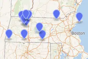
| Name | Image | County | Location | Built | Length | Crosses | Ownership | Truss | Notes |
|---|---|---|---|---|---|---|---|---|---|
| Bissell Bridge[2] | 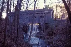 |
Franklin | Charlemont 42°37′57″N 72°52′10″W |
1951, rebuilt 2009 | 94 feet (29 m) | Mill Brook | Town of Charlemont | Long through | |
| Burkeville Covered Bridge[2] | 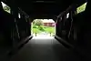 |
Franklin | Conway 42°29′1″N 72°42′44″W |
1870-1871, rebuilt 1999 | 106 feet (32 m) | South River (Deerfield River tributary) | Town of Conway | Multiple kingrod | Also called Conway Covered Bridge |
| Creamery Bridge[1]:68–69 | Franklin | Ashfield 42°31′11″N 72°48′3″W |
1985 | 40 feet (12 m) | Creamery Brook | Private | Queen | ||
| Dummerston/Vermont Bridge[1]:77–78 | 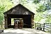 |
Worcester | Sturbridge 42°6′30″N 72°5′55″W |
1951 | 55 feet (17 m) | Arm of Quinebaug River | Old Sturbridge Village | Town | Also called Taft Bridge; located in Dummerston, Vermont prior to 1951 |
| Goodrich Bridge[1]:72–73 | Hampden | Westfield 42°7′22″N 72°47′10″W |
1965 | 40 feet (12 m) | Pond | Stanley Park | Town | ||
| Grays Sugarhouse Bridge[1]:69–70 | Franklin | Ashfield 42°32′43″N 72°46′50″W |
1994 | 20 feet (6.1 m) | Tributary of Bear River | Private | King | ||
| Green River Pumping Station Bridge[1]:71–72 | 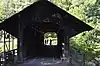 |
Franklin | Greenfield 42°38′47″N 72°37′13″W |
1972 | 94 feet (29 m) | Green River | State of Massachusetts | Howe | Also called Eunice Williams Bridge |
| Old Covered Bridge[2] | 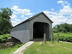 |
Berkshire | Sheffield 42°7′26″N 73°21′17″W |
1837-1838, 1854, rebuilt 1998 | 93 feet (28 m) | Housatonic River | Town of Sheffield | Town | Also called Upper Sheffield/Sheffield Bridge; original bridge burned in 1994 |
| Sawyer Pond Bridge[1]:62–63 | Essex | Magnolia 42°35′29″N 70°43′8″W |
1983 | 40 feet (12 m) | Sawyer Pond | Private | Town | ||
| Arthur A. Smith Covered Bridge[2] |  |
Franklin | Colrain 42°40′12″N 72°43′9″W |
1868, 1870, 1896, rebuilt 2006 | 98 feet (30 m) | North River | Town of Colrain | Burr | |
| Ware-Hardwick Covered Bridge[2] | 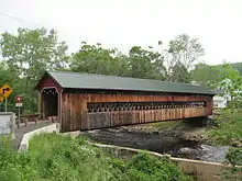 |
Hampshire and Worcester | Hardwick, Ware 42°18′37″N 72°12′45″W |
1886, rebuilt 1986 | 137 feet (42 m) | Ware River | Towns of Ware and Hardwick | Town | Also called Gilbertville/Ware Bridge |
| Chester/Charles H. Waterous Bridge[1]:75–76 |  |
Middlesex | East Pepperell 42°40′10″N 71°34′30″W |
1848, rebuilt 1962 and 2010 | 108 feet (33 m) | Nashua River | Town of Pepperell | Pratt variation | Also called Nehemiah Jewett's Bridge and Pepperell Bridge |
See also
References
- Evans, Benjamin D. and June R. (2004). New England's Covered Bridges. Lebanon, NH: University Press of New England. pp. 57-78. ISBN 1-58465-320-5.
- "National Register Information System". National Register of Historic Places. National Park Service. July 9, 2010.
Further reading
Burk, John S. (2010). Massachusetts Covered Bridges. Charleston, South Carolina: Arcadia Publishing. ISBN 978-0-73857323-6.
External links
| Wikimedia Commons has media related to Covered bridges in Massachusetts. |
- National Society for the Preservation of Covered Bridges
- Visit Massachusetts article about the state's covered bridges
This article is issued from Wikipedia. The text is licensed under Creative Commons - Attribution - Sharealike. Additional terms may apply for the media files.