List of covered bridges in New Brunswick
This is a list of covered bridges in New Brunswick. There are 58 covered bridges in the Canadian province of New Brunswick.[1] Bridges are single span, unless noted.
Existing bridges
| Name | County | Location | Built | Length (m) | Truss type | Notes | Photo |
|---|---|---|---|---|---|---|---|
| Coverdale River No. 3 (Colpitts, Bramford) | Albert | Colpitts Road, near Salisbury 45.988336°N 64.973774°W |
1943 | 31 | Burr variation | On Private Road | |
| Crooked Creek No. 3 | Albert | Crooked Creek Road. 45.7970°N 64.7767°W |
1945 | 28 | Howe & Queen | Not in service. In the Caledonia Gorge Protected Natural Area. | |
| Tantramar River No. 2 (Wheaton) | Westmorland | High Marsh Road 45.931726°N 64.330294°W |
1916 | 50 | Howe & Queen | The site until 1840 of a bridge on the post road, then called the Westmorland Great Road, the main route across the narrow Isthmus of Chignecto that connects Nova Scotia and New Brunswick.[2] | |
| Benton or Eel River No. 3 | York | Benton Road | 1927 | 32 | |||
| Forty Five River No. 1 | Albert | Forty-Five Road 45.6870°N 64.9530°W |
1914 | 29 | Howe & Queen | Built by Alex Garland.[3] In Fundy National Park. 17 ft roadway. | |
| Mitton William | Albert | Mitton Road, Riverview 46.043626098580326°N 64.87809317288605°W |
1942 | 23 | Not in service | ||
| Point Wolfe | Albert | Point Wolfe Road 45.5507°N 65.0130°W |
1992 | 29 | Howe & Queen | In Fundy National Park. Replaces the original bridge which had been built in 1916 and lost in 1990.[4] | |
| Sawmill Creek No. 0.5 | Albert | Hopewell Hill 45.7647°N 64.6925°W |
1908 | 33 | Not in service |
| |
| Shepody River No. 3 (Germantown Lake) | Albert | Midway Road 45.6667°N 64.8113°W |
1903 | 19 | Howe & Queen | ||
| Turtle Creek No. 4 (Jonah, Peter) | Albert | Dewey Road | 1912 | 20 | Not in service. Moved in 2013 to dry land. | ||
| Weldon Creek No. 3 (Steeves, Hartley) | Albert | Salem, near Hillsborough | 1923 | 18 | Howe & Queen | Built by John Forbes.[5] | |
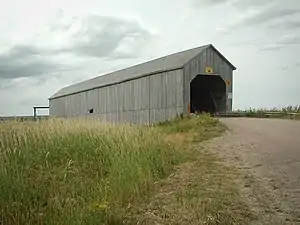
| Hartland | Carleton | Hartland | 1901 | 391 | Howe | Covered in 1921. National Historic Site and Provincial Historic Place. Longest covered bridge in the world.[6] Seven spans. | |
| Florenceville | Carleton | Florenceville | 1907 | 47 | Howe | A five-span bridge of which one is covered and the others are steel. | |
| North Becaguimec River No. 4 (Ellis) | Carleton | Lower Windsor | 1909 | 18 | Howe & Queen | ||
| Canal | Charlotte | Canal | 1917 | 38 | Howe & Queen | ||
| Dennis Stream No. 3 (Maxwell Crossing) | Charlotte | Old Ridge | 1910 | 18 | Howe | ||
| Digdeguash River (McGuire) No. 3 (McGuire) | Charlotte | Elmsville | 1913 | 35 | |||
| Digdeguash River (McCann) No. 4 (McCann) | Charlotte | 46.0029°N 64.9002°W | 1938 | 86 | |||
| Digdeguash River (Dumbarton) No. 6 (Dumbarton) | Charlotte | Tyron Road | 1928 | 76 | |||
| Little Lepreau River No. 1.5 (Mill Pond) | Charlotte | Little Lepreau | 1910 | 32 | .jpg.webp) | ||
| Magaguadavic River No. 7 (Flume Ridge) | Charlotte | Flume Falls | 1905 | 18 | Modified Pratt & Queen | ||
| Graham Creek | Kent | Route 510 | 1928 | 41 | |||
| Kouchibouguasis No. 5 (Camerons Mill) | Kent | Camerons Mill | 1950 | 42 | |||
| Belleisle Creek No. 2 (Marven) | Kings | Swamp Road | 1903 | 22 | |||
| Bloomfield Creek | Kings | Bloomfield Station Road | 1917 | 45 | |||
| Darlings Island | Kings | Darlings Island Road | 1914 | 42 | Not in service | ||
| Kennebecasis River (Salmon) | Kings | Route 890 | 1908 | 34 | Not in service | ||
| Hammond River No. 3 (Smithtown) | Kings | Damascus Road | 1914 | 56 | |||
| Kennebecasis River (Malone) | Kings | Goshen Road | 1911 | 18 | |||
| Kennebecasis River (Plumweseep) | Kings | Plumweseep | 1911 | 23 | Named for the Maliseet word for Salmon River.[7] | ||
| Millstream River | Kings | Pleasant Ridge Branch Road | 1911 | 29 | |||
| Milkish Inlet No. 1 (Bayswater) | Kings | Route 845 | 1920 | 67 | |||
| Smith Creek No. 1 (Tranton) | Kings | Roachville | 1927 | 37 | |||
| Moosehorn Creek No. 1.5 | Kings | Riverview Drive South | 1915 | 29 | Not in service | ||
| Trout Creek No. 5 (Moores Mills) | Kings | Urney Road | 1905 | 20 | |||
| Smith Creek No. 5 (Oldfields) | Kings | Oldfield Road | 1910 | 28 | Was pictured on 1992 quarter.[8] | ||
| Ward's Creek No.2 (MacFarlane) | Kings | Upper Wards Creek | 1909 | 18 | |||
| Baker Brook No. 2 (Morneault) | Madawaska | Cyr Street | 1939 | 29 | Not in service | ||
| Green River No. 3 (Boniface) | Madawaska | Boniface Road | 1925 | 58 | |||
| Quisibis River No. 2 | Madawaska | Deschenes Road | 1951 | 17 |  | ||
| Mill Brook No. 0.5 (Nelson Hollow) | Northumberland | Lyons Road | 1900 | 25 | Not in service. Oldest covered bridge in New Brunswick.[9] | ||
| Gaspereau River No. 2 (Burpee) | Queens | Upper Gaspereau | 1913 | 50 | |||
| Long Creek No. 1 (Starkey) | Queens | Starkey Road | 1912 | 42 |
 | ||
| Irish River No. 2 (Hardscrabble) | Saint John | St. Martins | 1946 | 22 |  | ||
| Tynemouth Creek | Saint John | Tynemouth | 1927 | 29 | |||
| Irish River No. 1 (Vaughan Creek) | Saint John | St. Martins | 1935 | 22 | Not in service | ||
| Back Creek No. 2 (Hoyt Station) | Sunbury | Hoyt Station Road | 1936 | 29 | |||
| Rusagonis River No. 2 (Patrick Owens) | Sunbury | Wilsey Road | 1909 | 70 | 2 spans | ||
| South Oromocto River No. 3 (Bell) | Sunbury | Mill Settlement | 1912 | 42 | |||
| Odellach River No. 2 (Tomlinson Mill) | Victoria | Tomlinson Mill Road | 1918 | 18 | |||
| Cocagne River (Poirier) | Westmorland | Poirier Office Road | 1942 | 41 | |||
| Cocagne River (Budd) | Westmorland | Victoria Road | 1913 | 25 | |||
| Coverdale River No. 7 (now at Magnetic Hill) | Westmorland | Magnetic Hill Theme Park | 1983 | 18 | Not owned by DTI | ||
| Memramcook River No. 4 (Boudreau) | Westmorland | Gayton Road | 1930 | 23 |  | ||
| William Mitton Bridge | Westmorland | Powers Pit Road | 1930 | 38 | Not in service | ||
| Shediac River No. 4 (Joshua Gallant) | Westmorland | Shediac River Road | 1935 | 26 | Not in service | ||
| Nackawick River No. 5 (Nackawic Siding) | York | Nortondale | 1927 | 18 |
.jpg.webp)
.jpg.webp)
Defunct bridges
.jpg.webp)
Canaan River New Brunswick, now defunct
In 2018, the 87-year old Bell Bridge, near Hoyt, south of Fredericton, was demolished.[10]
In 2017, a 104-year-old covered bridge (Hammond River No. 2) over the Hammond River was demolished and replaced with a modular bridge. According to the provincial government, local residents did not wish to save it.[11]
In 2014, the Cherryvale covered bridge, built in 1927, was washed away by flooding on the Canaan River and destroyed.[12]
In 2001, the 82-year-old Mundleville covered bridge burned down.[13] At 153 metres, it was the second longest covered bridge in the province.[14][15]
References
- Government of New Brunswick, Canada (7 October 2011). "New Brunswick's Covered Bridges - Transportation and Infrastructure". www2.gnb.ca. Retrieved 13 January 2019.
- "Wheaton Covered Bridge". Tantramar Historic Sites. Retrieved 14 January 2019.
- "Lower Forty Five #1, Albert County". Covered Spans of Yesteryear. Retrieved 13 January 2019.
- "Point Wolfe, Albert County". www.lostbridges.org. Retrieved 13 January 2019.
- "Hartley Steeves or Weldon Creek #3, Albert County". www.lostbridges.org. Retrieved 13 January 2019.
- "Hartland Covered Bridge". Tourism New Brunswick. Retrieved 13 January 2019.
- "Covered Bridges: A Part of New Brunswick's Heritage". Provincial Archives of New Brunswick. Retrieved 7 January 2020.
- Government of New Brunswick, Canada (12 October 2011). "Kings County - Covered Bridge - New Brunswick". www2.gnb.ca. Retrieved 14 January 2019.
- "Mill Brook No. 0.5 Covered Bridge (Nelson Hollow)". Tourism New Brunswick. Retrieved 13 January 2019.
- Fowler, Shane (17 January 2018). "Demolition of Hoyt's 87-year-old Bell Bridge is underway | CBC News". CBC. Retrieved 13 January 2019.
- Pruss, Viola. "Covered bridge across Hammond River to be replaced with modular one". CBC. Retrieved 13 April 2019.
- "Cherryvale's 87-year-old covered bridge being disassembled - New Brunswick | Globalnews.ca". globalnews.ca. 9 September 2014. Retrieved 13 January 2019.
- "Squeaky wheel gets bridge". CBC News. 9 March 2001. Retrieved 14 April 2020.
- "Bridge Losses 1954-2001" (PDF). archives.gnb.ca. Provincial Archives of New Brunswick. 31 August 2004. Retrieved 14 April 2020.
- "Loss of bridge inconvenience for area residents". CBC News. 5 March 2001. Retrieved 14 April 2020.
This article is issued from Wikipedia. The text is licensed under Creative Commons - Attribution - Sharealike. Additional terms may apply for the media files.