St. Martins, New Brunswick
St. Martins is a village on the Bay of Fundy in Saint John County, New Brunswick, Canada. The village had a population of 276 as of the 2016 census.[1]
Village of St. Martins | |
|---|---|
Village | |
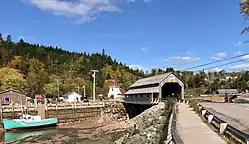 St. Martins and its twin covered bridges | |
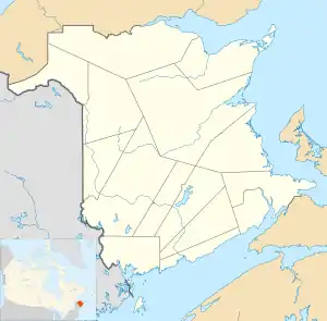 St. Martins Location of St. Martins in New Brunswick  St. Martins St. Martins (Canada) | |
| Coordinates: 45°21′1.6″N 65°32′2.3″W | |
| Country | |
| Province | |
| County | Saint John County |
| Parish | Saint Martins Parish |
| Government | |
| • Type | Village council |
| • Mayor | Bette Ann Chatterton |
| • Deputy Mayor | Jason Garnett |
| Area | |
| • Land | 2.35 km2 (0.91 sq mi) |
| Population | |
| • Total | 276 |
| • Density | 117.4/km2 (304/sq mi) |
| • Change 2011-16 | |
| Time zone | UTC-4 (Atlantic) |
| • Summer (DST) | UTC-3 (ADT) |
| Area code(s) | 506 |
| Website | www |
 | |
New Brunswick | |
| |
| Location | St. Martins New Brunswick Canada |
|---|---|
| Coordinates | 45°19′26.29″N 65°32′7.2″W |
| Year first constructed | 1835 (first) 1883 (second) |
| Year first lit | 1966 (current) |
| Deactivated | 1881 (first, destroyed by fire) 1966 (second) |
| Foundation | Concrete base |
| Construction | Concrete tower (current) |
| Tower shape | Quadrangular tower with balcony and lantern |
| Markings / pattern | White tower, red lantern |
| Tower height | 11.9 metres (39 ft) |
| Focal height | 26 metres (85 ft) |
| Light source | Solar power |
| Range | 21 nautical miles (39 km; 24 mi)[2] |
| Characteristic | Fl W 10s. |
| Fog signal | 3s. blast every 30s. |
| Admiralty number | H4076 |
| CHS number | CCG 150 |
| NGA number | 11080 |
| ARLHS number | CAN-421 |
| Managing agent | Canadian Coast Guard[3][4] |
The village was founded as Quaco by 1783 by soldiers from the disbanded loyalist King's Orange Rangers. It was incorporated in 1967. Led by shipbuilders such as James Moran, it was the third most productive shipbuilding town in the Maritimes, producing over 500 ships.[5] Shipbuilding declined after the 1870s and today tourism is the major industry.[6]
Attractions
Attractions in St. Martins include the St. Martins Sea Caves,[7] the beach and tidal harbour,[8] the start of the Fundy Trail,[9] two covered bridges and the Quaco Head Lighthouse, the Quaco Museum and Library,[10] and the Fundy Trail Parkway.[11]
Demographics
| Year | Pop. | ±% |
|---|---|---|
| 2006 | 386 | — |
| 2011 | 314 | −18.7% |
| 2016 | 276 | −12.1% |
| [1] | ||
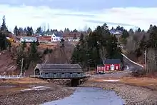
Gallery
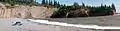 St. Martins' Caves
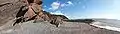 Fundy Trail
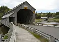 Twin covered bridges
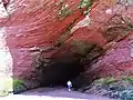 St Martins Sea Cave
Further reading
- Hebb, Ross M., Quaco - St. Martins: A Brief History, 1997. Fredericton, NB: Quaco/Springhill Press. ISBN 0-9682579-0-9
See also
References
- "Census Profile, 2016 Census: St. Martins, Village [Census subdivision], New Brunswick". Statistics Canada. Retrieved September 29, 2019.
- List of Lights, Pub. 110: Greenland, The East Coasts of North and South America (Excluding Continental U.S.A. Except the East Coast of Florida) and the West Indies (PDF). List of Lights. United States National Geospatial-Intelligence Agency. 2015.
- "Southern New Brunswick". The Lighthouse Directory. University of North Carolina at Chapel Hill. Retrieved 29 March 2017.
- "Quaco Head, NB". Lighthouse Friends. Retrieved 29 March 2017.
- "Living History". Retrieved 14 September 2017.
- "Village of St. Martins". Retrieved 14 September 2017.
- "St. Martins Sea Caves". Retrieved September 14, 2017.
- "Tidal Harbour". Retrieved September 14, 2017.
- "Awe-inspiring Fundy Trail". Retrieved September 14, 2017.
- "Quaco Museum". Quaco Historical & Library Society. Retrieved September 14, 2017.
- "Fundy Trail Parkway". Retrieved September 29, 2019.
External links
- Aids to Navigation Canadian Coast Guard
| Wikimedia Commons has media related to St. Martins, New Brunswick. |