List of earthquakes in Oklahoma
The following is a list of historical earthquakes with epicenters located within the boundaries of Oklahoma. Only earthquakes of greater than or equal to magnitude 4.5 are included. Information pertaining to time, magnitude, epicenter, and depth is retrieved from the United States Geological Survey or, when USGS information is unavailable, the Oklahoma Geological Survey where applicable. All times are given in Coordinated Universal Time (UTC) rather than local time (CT).
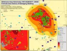
Seismic hazard and seismicity map for Oklahoma and vicinity in 2017 – incorporates hazard from induced seismicity
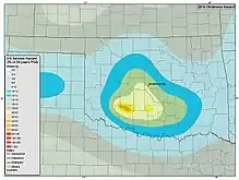
Oklahoma portion of 2014 National Seismic Hazard Map – does not incorporate hazard from induced seismicity
Earthquakes
| Date (UTC) | Time (UTC) |
Area | Magnitude | Epicenter | Depth (km) |
Article link | Source |
|---|---|---|---|---|---|---|---|
| ~1,100 years ago | Unknown | Meers Fault | ~7 M | Unknown | Unknown | N/A | [1] |
| October 22, 1882 | Unknown | Fort Gibson, Muskogee County | Unknown | Unknown | Unknown | N/A | [2] |
| April 9, 1952 | 16:29:28 | El Reno, Canadian County | 5.5 Ms, mb | 35.4°N 97.8°W | 10 | N/A | [3][4][5] |
| February 15, 1974 | 13:33:49 | Huntoon, Ochiltree County, TX | 4.5 mb | 36.500°N 100.693°W | 24.0 | N/A | [6] |
| September 6, 1997 | 23:38:00 | Lula, Pontotoc County | 4.5 mbLg | 34.660°N 96.435°W | 5.0 | N/A | [7] |
| November 5, 2011 | 07:12:45 | Sparks, Lincoln County | 4.8 Mwr | 35.550°N 96.764°W | 3.1 | N/A | [8] |
| November 6, 2011 | 03:53:10 | Prague, Lincoln County | 5.7 Mww | 35.532°N 96.765°W | 5.2 | 2011 Oklahoma earthquake | [9] |
| November 8, 2011 | 02:46:57 | Sparks, Lincoln County | 4.8 Mwr | 35.531°N 96.788°W | 5.0 | N/A | [10] |
| December 7, 2013 | 18:10:24 | Edmond, Oklahoma County | 4.5 Mwr | 35.607°N 97.386°W | 8.4 | N/A | [11] |
| July 27, 2015 | 18:12:15 | Crescent, Logan County | 4.5 Mwr | 35.989°N 97.572°W | 5.0 | N/A | [12] |
| November 19, 2015 | 07:42:12 | Cherokee, Alfalfa County | 4.7 Mwr | 36.660°N 98.459°W | 5.9 | N/A | [13] |
| November 30, 2015 | 09:49:12 | Cherokee, Alfalfa County | 4.7 Mwr | 36.751°N 98.056°W | 5.6 | N/A | [14] |
| January 7, 2016 | 04:27:57 | Fairview, Major County | 4.7 Mww | 36.496°N 98.725°W | 4.1 | N/A | [15] |
| February 13, 2016 | 17:07:06 | Fairview, Major County | 5.1 Mww | 36.490°N 98.709°W | 8.3 | N/A | [16] |
| September 3, 2016 | 12:02:44 | Pawnee, Pawnee County | 5.8 Mww | 36.425°N 96.929°W | 5.6 | 2016 Oklahoma earthquake | [17] |
| November 2, 2016 | 04:26:54 | Pawnee, Pawnee County | 4.5 Mwr | 36.308°N 96.647°W | 2.6 | N/A | [18] |
| November 7, 2016 | 01:44:24 | Cushing, Payne County | 5.0 Mww | 35.984°N 96.798°W | 5.0 | N/A | [19] |
| April 7, 2018 | 12:16:01 | Perry, Noble County | 4.6 Mww | 36.290°N 97.517°W | 5.8 | N/A | [20] |
| April 9, 2018 | 10:22:20 | Perry, Noble County | 4.6 Mww | 36.219°N 97.574°W | 4.9 | N/A | [21] |
See also
References
- Walsh, F. Rall III; Zoback, Mark D. (June 18, 2015). "Oklahoma's recent earthquakes and saltwater disposal". Science. American Association for the Advancement of Science. 1 (5): e1500195. doi:10.1126/sciadv.1500195. PMC 4640601. PMID 26601200. Retrieved October 3, 2016.
- Luza, Kenneth V. (2016). "Earthquakes". Encyclopedia of Oklahoma History & Culture. Oklahoma Historical Society. Retrieved October 1, 2016.
- "OGS 4.0+ Magnitude Earthquake Catalog". Oklahoma Geological Survey. September 2016. Retrieved October 1, 2016.
- Lawson, James E., Jr.; Luza, Kenneth V.; Brown, Raymon L.; Moss, Dan (April 1992). "Oklahoma Earthquakes, 1991". In Cooper, Christie (ed.). Oklahoma Geology (PDF) (Report). 52. Oklahoma Geological Survey. pp. 48–59. ISSN 0030-1736. Retrieved October 3, 2016.
- Stover, Carl W.; Coffman, Jerry L. (1993). Seismicity of the United States, 1568–1989 (Revised). U.S. Government Printing Office. p. 334.
- "M 4.5 - Oklahoma". United States Geological Survey. February 15, 1974. Retrieved October 1, 2016.
- "M 4.5 - Oklahoma". United States Geological Survey. September 6, 1997. Retrieved October 1, 2016.
- "M 4.8 - Oklahoma". United States Geological Survey. November 5, 2011. Retrieved October 1, 2016.
- "M 5.7 - Oklahoma". United States Geological Survey. November 5, 2011. Retrieved October 1, 2016.
- "M 4.8 - Oklahoma". United States Geological Survey. November 7, 2011. Retrieved October 1, 2016.
- "M 4.5 - 9km ESE of Edmond, Oklahoma". United States Geological Survey. December 7, 2013. Retrieved October 1, 2016.
- "M 4.5 - 4km NNE of Crescent, Oklahoma". United States Geological Survey. July 27, 2015. Retrieved October 1, 2016.
- "M 4.7 - 13km SW of Cherokee, Oklahoma". United States Geological Survey. November 19, 2015. Retrieved October 1, 2016.
- "M 4.7 - 26km E of Cherokee, Oklahoma". United States Geological Survey. November 30, 2015. Retrieved October 1, 2016.
- "M 4.7 - 33km NW of Fairview, Oklahoma". United States Geological Survey. January 6, 2016. Retrieved October 1, 2016.
- "M 5.1 - 31km NW of Fairview, Oklahoma". United States Geological Survey. February 13, 2016. Retrieved October 1, 2016.
- "M5.8 - 14km NW of Pawnee, Oklahoma". United States Geological Survey. September 3, 2016. Retrieved October 1, 2016.
- "M4.5 - 14km ESE of Pawnee, Oklahoma". United States Geological Survey. November 2, 2016. Retrieved November 2, 2016.
- "M5.0 - 2km W of Cushing, Oklahoma". United States Geological Survey. November 6, 2016. Retrieved November 6, 2016.
- "M 4.6 - 20km W of Perry, Oklahoma". United States Geological Survey. April 7, 2018. Retrieved August 14, 2019.
- "M 4.6 - 26km WSW of Perry, Oklahoma". United States Geological Survey. April 9, 2018. Retrieved August 14, 2019.
External links
- Magnitude 4.5+ Earthquakes in Oklahoma from the United States Geological Survey - List incomplete for older earthquakes.
 Media related to Earthquakes in Oklahoma at Wikimedia Commons
This article is issued from Wikipedia. The text is licensed under Creative Commons - Attribution - Sharealike. Additional terms may apply for the media files.