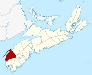
List of historic places in Digby County, Nova Scotia
List of historic places
| Name | Address | Coordinates | IDF | IDP | IDM | Image | |
|---|---|---|---|---|---|---|---|
| All Saints Anglican Church and Cemetery | 10219 Route 217, Rossway, NS | 44°35′05″N 65°54′10″W | 6236 |  | |||
| Bayside Farm | 580 Fort Point Road, Weymouth North, NS | 44°27′11″N 66°00′09″W | 1315 | | |||
| Bayview United Church | 1074 Lighthouse Road, Bay View, NS | 44°40′40″N 65°46′25″W | 1316 | | |||
| Bear River Lighthouse | Evangeline Trail, Digby, NS | 44°37′06″N 65°41′19″W | 20771 | | |||
| Boars Head Lighthouse | Boars Head Road, Tiverton, NS | 44°24′14″N 66°12′55″W | 21194 | | |||
| Cape St. Marys Lighthouse | Lighthouse Road, Clare, NS | 44°05′09″N 66°12′39″W | 20893 | | |||
| Centreville United Church | 34 Trout Cove Road, Centreville, NS | 44°32′46″N 66°00′47″W | 1319 | | |||
| Captain Cheney's Homestead | 86 Shore Road, Little River, NS | 44°26′39″N 66°08′23″W | 1314 | | |||
| Church of the Nativity | 321 Sandy Cove Road, Sandy Cove, NS | 44°29′25″N 66°05′32″W | 1318 | | |||
| Culloden Baptist Church | 1643 Culloden Road, Culloden, NS | 44°39′19″N 65°50′02″W | 1338 | | |||
| Dickson Residence (Captain John Squires Eldridge House) | 46 Bayshore Road, Sandy Cove, NS | 44°29′32″N 66°05′22″W | 1372 | | |||
| Fitzgerald House | 74 Fort Point Road, Weymouth, NS | 44°26′18″N 65°59′54″W | 1340 | | |||
| Former Saint Thomas Anglican Church | 4668 Main Street, Weymouth, NS | 44°24′49″N 65°59′46″W | 1373 | | |||
| Former Southville Church of Christ | 807 Langford Road, Southville, NS | 44°21′09″N 65°53′59″W | 1379 | | |||
| Gardenia Lodge-Savary House | No. 101 Highway, Plympton, NS | 44°30′41″N 65°54′23″W | 7992 | | |||
| Gilbert's Cove Lighthouse | 244 Lighthouse Road, Gilbert's Cove, NS | 44°29′39″N 65°57′08″W | 1261 |  | |||
| Haight Residence | 1721 Ridge Road, Hillgrove, NS | 44°31′35″N 65°48′08″W | 1374 | | |||
| Isaac LeBlanc House | 33 Isaac LeBlanc Chemain, Church Point, NS | 44°19′31″N 66°07′10″W | 5388 | | |||
| Little River United Baptist Church | Highway 217, Little River, NS | 44°26′34″N 66°08′57″W | 1339 | | |||
| Oddfellows Hall | 7 Second Street, Westport, NS | 44°15′42″N 66°21′11″W | 1343 | | |||
| Payson House | 4458 No. 1 Highway, Weymouth, NS | 44°24′17″N 65°59′56″W | 6494 | 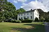 | |||
| Stephen Payson Homestead | 4471 Highway Number one, Weymouth, NS | 44°24′19″N 65°59′55″W | 1383 | 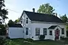 | |||
| Pointe à Major Cemetery | 245 Doucette Point Road, Belliveau's Cove, NS | 44°23′04″N 66°04′47″W | 16023 | | |||
| Prim Point Lighthouse | Lighthouse Road, Digby, NS | 44°41′28″N 65°47′11″W | 20770 | | |||
| St. John the Baptist Church | No. 340 Highway, Corberrie, NS | 44°14′07″N 65°55′45″W | 6238 | | |||
| Sainte Marie Church | 1713 Highway No. 1, Church Point, NS | 44°20′02″N 66°06′58″W | 5390 |  | |||
| Saint Peter's Church | 5 Fort Point Branch, Weymouth North, NS | 44°26′19″N 65°59′40″W | 1377 | | |||
| Sandy Cove United Baptist Church | 350 Sandy Cove Road, Sandy Cove, NS | 44°29′25″N 66°05′24″W | 1381 | | |||
| Smith's Cove Baptist Meeting House and Temperance Hall | Highway No. 1, Smith's Cove, NS | 44°36′40″N 65°42′24″W | 3077 | | |||
| Smith's Cove United Church | 660 Highway No.1, Smith's Cove, NS | 44°36′45″N 65°42′10″W | 1384 | | |||
| Trinity Anglican Church National Historic Site of Canada | 87 Queen Street, Digby, NS | 44°37′09″N 65°45′24″W | 10584 | 7266 | | ||
| Ward House | 215 Trout Cove Road, Centreville, NS | 44°32′48″N 66°01′41″W | 1375 | | |||
| Westport United Baptist Church | 50 Wellington Street, Westport, NS | 44°15′40″N 66°21′15″W | 4098 | | |||
| Westway Inn | 5 French Road, Plympton, NS | 44°30′16″N 65°54′58″W | 1385 | | |||
| Weymouth Trading Post (Campbell's Store) | 4613 Highway Number One, Weymouth, NS | 44°24′40″N 65°59′46″W | 1317 | 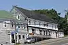 | |||
| Zion United Church | 325 Sandy Cove Road, Sandy Cove, NS | 44°29′27″N 66°05′32″W | 1382 | |
See also
| Wikimedia Commons has media related to Cultural heritage monuments in Digby County. |
- List of historic places in Nova Scotia
- List of National Historic Sites of Canada in Nova Scotia
- Heritage Property Act (Nova Scotia)
This article is issued from Wikipedia. The text is licensed under Creative Commons - Attribution - Sharealike. Additional terms may apply for the media files.