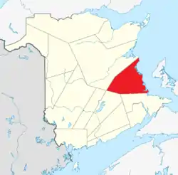
List of historic places in Kent County, New Brunswick
This article is a list of historic places in Kent County, New Brunswick entered on the Canadian Register of Historic Places, whether they are federal, provincial, or municipal.
List of historic places
| Name | Address | Coordinates | IDF | IDP | IDM | Image | |
|---|---|---|---|---|---|---|---|
| Albert, Allain, Robitaille et Cormier House | 8 Bellevue Street, Bouctouche, NB | 46°28′25″N 64°43′13″W | 7925 |  | |||
| Télesphore Arsenault Residence | 9446 Main Street, Richibucto, NB | 46°41′14″N 64°51′49″W | 15704 | | |||
| Ballast Heaps | In the Richibucto River, Richibucto, NB | 46°41′16″N 64°51′17″W | 16346 | | |||
| MLA James Barnes's House | 53 Acadie Avenue, Bouctouche, NB | 46°27′59″N 64°42′35″W | 5384 | | |||
| Birthplace of Louis J. Robichaud | 4 Camille Avenue, Saint-Antoine, NB | 46°21′43″N 64°45′09″W | 7291 | | |||
| Bonar Law House | 31 Bonar Law Avenue (Route 116), Rexton, NB | 46°38′38″N 64°52′50″W | 6215 | 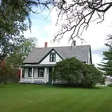 | |||
| Bordage General Store | 10520 Principale Street, Saint-Louis-de-Kent, NB | 46°44′11″N 64°58′20″W | 5909 | | |||
| Camille Bordage Pharmacie | 9382 Main Street, Richibucto, NB | 46°40′56″N 64°51′46″W | 15762 | | |||
| Bouctouche Seaport | Irving Boulevard, Bouctouche, NB | 46°28′21″N 64°43′09″W | 5410 | | |||
| Bouctouche Train Station Site | De la Riviere Street, Bouctouche, NB | 46°28′15″N 64°43′17″W | 8692 | | |||
| Bourque-Robichaud House | 9398 Main Street, Richibucto, NB | 46°41′01″N 64°51′44″W | 15744 | | |||
| Brait House | 1 School Street, Rexton, NB | 46°38′33″N 64°52′13″W | 5240 | | |||
| Brideau House | 10 542 Principale Street, Saint-Louis-de-Kent, NB | 46°44′15″N 64°58′26″W | 7905 | | |||
| Burns Mill Site | 44 Sunset Drive, Rexton, NB | 46°38′29″N 64°52′41″W | 5448 | | |||
| Camille Vautour Presbytery | 24 de l'Eglise Avenue, Saint-Antoine, NB | 46°21′48″N 64°45′18″W | 7342 | | |||
| Carrefour de la culture acadienne | de l'Eglise Avenue, Saint-Antoine, NB | 46°21′48″N 64°45′15″W | 7096 | | |||
| The Cedars | 78 Main Street, Rexton, NB | 46°39′08″N 64°52′40″W | 4136 | | |||
| Church of the Immaculate Conception | 8 School Street, Rexton, NB | 46°38′29″N 64°52′15″W | 4143 | | |||
| Church of the Immaculate Conception Cemetery | 16 School Street, Rexton, NB | 46°38′25″N 64°52′14″W | 5541 | | |||
| Convent of the Immaculate Conception | 150 du Couvent Road, Bouctouche, NB | 46°28′50″N 64°41′57″W | 2498 | | |||
| Cradle of the Acadian Flag | Located at the corner of Principale Street and Cote Nord Road, Saint-Louis-de-Kent, NB | 46°44′31″N 64°58′53″W | 6156 | | |||
| Lestock DesBrisay House | 9388 Main Street, Richibucto, NB | 46°40′56″N 64°51′45″W | 15705 | | |||
| First Stella-Maris Hospital | 127 Du Couvent Road, Bouctouche, NB | 46°28′44″N 64°42′07″W | 8312 | | |||
| The Forge | 10 610 Principale Street, Saint-Louis-de-Kent, NB | 46°44′28″N 64°58′49″W | 7904 | | |||
| Former Bouctouche Railway Route | Yvon Street, Saint-Antoine, NB | 46°21′48″N 64°45′01″W | 7396 | | |||
| Former Home of MP Gilbert Girouard | 20 Bellevue Street, Bouctouche, NB | 46°28′27″N 64°43′13″W | 5525 | | |||
| Former Railway Station | 10617 Principale Street, Saint-Louis-de-Kent, NB | 46°44′33″N 64°58′49″W | 6635 | | |||
| Founders' Site | 17 Caissie Street, Saint-Antoine, NB | 46°21′42″N 64°45′50″W | 7357 | | |||
| Grotto and Calvary | Principale Street, Saint-Louis-de-Kent, NB | 46°44′21″N 64°58′40″W | 5960 | | |||
| Higho de Cocagne Institutional Centre | 98 de l'Eglise Avenue, Saint-Antoine, NB | 46°21′48″N 64°45′49″W | 7358 | | |||
| Jardine's Inn | 104 Main Street, Rexton, NB | 46°38′57″N 64°52′35″W | 4852 | | |||
| John Jardine House | 30 King Street, Rexton, NB | 46°38′44″N 64°51′53″W | 4493 | | |||
| Kent Northern Hotel | 125 Main Street, Rexton, NB | 46°38′50″N 64°52′27″W | 5415 | | |||
| Lanigan and Bowser Mill Site | At the end of North Street, Rexton, NB | 46°38′52″N 64°52′10″W | 4489 | | |||
| LeBlanc House | 4511 Principale Street, Saint-Antoine, NB | 46°21′41″N 64°45′00″W | 7364 | | |||
| Gilbert Léger Store | 4543 Principale Street, Saint-Antoine, NB | 46°21′47″N 64°45′09″W | 7378 | | |||
| Léger Brothers Mill Site | 7 Champ Dore Road, Saint-Antoine, NB | 46°22′13″N 64°45′39″W | 7393 | | |||
| The Lilacs | 33 Sunset Drive, Rexton, NB | 46°38′26″N 64°52′33″W | 4491 | | |||
| Masonic Hall | 9378 Main Street, Richibucto, NB | 46°40′53″N 64°51′45″W | 15745 | | |||
| Dr. Lawrence McLaren House | 15 Acadie Street, Richibucto, NB | 46°40′31″N 64°52′04″W | 15703 | | |||
| McLeod-Mundle House | 9420 Main Street, Richibucto, NB | 46°41′04″N 64°51′44″W | 15706 | | |||
| François-Xavier Michaud Manse | 157 chemin du Couvent, Bouctouche, NB | 46°28′21″N 64°43′20″W | 5351 | | |||
| Monument to the Founding Families of Bouctouche | between 70 and 76 Acadie Avenue, Bouctouche, NB | 46°27′57″N 64°42′28″W | 5405 | | |||
| Old Bouctouche Post Office | 59 Irving Boulevard, Bouctouche, NB | 46°28′17″N 64°43′20″W | 5344 | | |||
| Old Kingston Hall | 79 Main Street, Rexton, NB | 46°39′07″N 64°52′35″W | 4106 | | |||
| Daniel O'Leary Property | 92 Acadie Street, Richibucto, NB | 46°40′54″N 64°51′52″W | 15748 | | |||
| Henry O'Leary House | 9402 Main Street, Richibucto, NB | 46°41′01″N 64°51′44″W | 15761 | | |||
| de Olloqui House | 12 Sunset Drive, Rexton, NB | 46°38′32″N 64°52′20″W | 4748 | | |||
| Palmer's Store | 125 Main Street, Rexton, NB | 46°38′49″N 64°52′29″W | 5540 | | |||
| Picnic Grounds | Corner of Principale Street and Cape Road, Saint-Louis-de-Kent, NB | 46°44′12″N 64°58′17″W | 5959 | | |||
| Pioneers' Cemetery | 69 de l'Eglise Avenue, Saint-Antoine, NB | 46°21′46″N 64°45′41″W | 7361 | | |||
| Pointe-à-Jacquot | Du Couvent Road, Bouctouche, NB | 46°28′44″N 64°41′47″W | 9470 | | |||
| Post Office of 1897 | 119 Main Street, Rexton, NB | 46°38′51″N 64°52′27″W | 5546 | | |||
| Presbyterian Church | 59 Acadie Street, Richibucto, NB | 46°40′45″N 64°51′57″W | 15773 | | |||
| Renzetta Residence | 21 Court Street, Richibucto, NB | 46°40′49″N 64°51′51″W | 15702 | | |||
| Rexton Bridge | 135 Route 134, Rexton, NB | 46°38′41″N 64°52′24″W | 16145 | | |||
| Richibucto Marine Hospital | 36 Indian Rock Lane, Rexton, NB | 46°39′35″N 64°52′07″W | 1943 | | |||
| Royal Bank | 9393 Main Street, Richibucto, NB | 46°40′57″N 64°51′44″W | 15770 | | |||
| Sacré-Cœur Chapel | 150 chemin du Couvent, Bouctouche, NB | 46°28′50″N 64°42′01″W | 5409 | | |||
| St. Andrew's United Church | 21 Water Street, Rexton, NB | 46°38′55″N 64°52′20″W | 4740 | 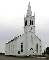 | |||
| St. Andrew's United Church Cemetery | 22 North Street, Rexton, NB | 46°38′56″N 64°52′17″W | 5416 | | |||
| Saint-Antoine l'Ermite Church | 28 de l'Eglise Avenue, Saint-Antoine, NB | 46°21′47″N 64°45′18″W | 7366 | | |||
| Saint-Jean-Baptiste Church | 21 Irving Boulevard, Bouctouche, NB | 46°28′25″N 64°43′14″W | 5404 | 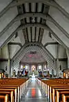 | |||
| Saint-Jean-Baptiste Parish Manse | 19 Irving Boulevard, Bouctouche, NB | 46°28′24″N 64°43′15″W | 6615 | | |||
| St. John the Evangelist Anglican Church | 2 Queen Street, Rexton, NB | 46°38′34″N 64°52′08″W | 1968 | | |||
| St. Lawrence Anglican Church | 42 Acadie Street, Bouctouche, NB | 46°28′04″N 64°42′38″W | 2574 | 6613 | | ||
| Saint-Louis College Site | 8 Cote Nord Road, Saint-Louis-de-Kent, NB | 46°44′30″N 64°58′53″W | 6834 | | |||
| Saint-Louis-de-Gonzague Church | 9440 Main Street, Richibucto, NB | 46°41′14″N 64°51′49″W | 15750 | 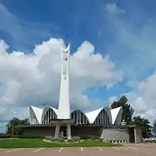 | |||
| Sisters of the Congregation of Notre-Dame Convent | 9 Soleil-Couchant Street, Saint-Louis-de-Kent, NB | 46°44′15″N 64°58′33″W | 7906 | | |||
| Site of the Former Agricultural Society Establishments | 124 Irving Boulevard, Bouctouche, NB | 46°28′08″N 64°43′33″W | 9959 | | |||
| Site of the Old Butter Factory | 10 575 Principale Street, Saint-Louis-de-Kent, NB | 46°44′25″N 64°58′37″W | 5910 | | |||
| Soy-Irving House | 1 Water Street, Rexton, NB | 46°38′56″N 64°52′35″W | 10629 | | |||
| John Stevenson House | 9336 Main Street, Richibucto, NB | 46°40′42″N 64°51′49″W | 15707 | | |||
| H. O. Stewart General Store | 127 Main Street, Rexton, NB | 46°38′49″N 64°52′27″W | 5431 | | |||
| Tower | Caissie Point, Dundas, NB | 46°19′12″N 64°30′45″W | 4668 | | |||
| Wolastoq National Historic Site of Canada | Entire watershed of Saint John River, central and western New Brunswick, parts of southeastern Quebec, NB | 46°19′43″N 65°37′08″W | 18954 | 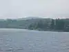 More images | |||
| The Yard | 45,47,49 River Street, Rexton, NB | 46°38′47″N 64°51′56″W | 4668 | |
See also
| Wikimedia Commons has media related to Cultural heritage monuments in New Brunswick. |
This article is issued from Wikipedia. The text is licensed under Creative Commons - Attribution - Sharealike. Additional terms may apply for the media files.