Saint-Louis-de-Kent, New Brunswick
Saint-Louis-de-Kent is a Canadian village in Kent County, New Brunswick.
Saint-Louis-de-Kent | |
|---|---|
Village | |
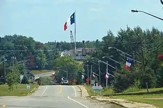 A huge Acadian flag dominates St-Louis' skyline | |
Seal | |
| Motto(s): Le berceau du drapeau acadien | |
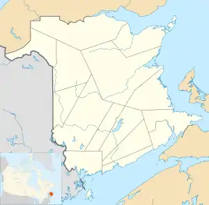 Saint-Louis-de-Kent Location within New Brunswick | |
| Coordinates: 46.738°N 64.974°W | |
| Country | |
| Province | New Brunswick |
| County | Kent County |
| Founded | 1797 |
| Incorporated | November 9, 1966 |
| Government | |
| • Mayor | Danielle Andrée Dugas |
| • Governing Body | Saint-Louis-de-Kent Village Council |
| Area | |
| • Total | 2.01 km2 (0.78 sq mi) |
| Population (2016)[1] | |
| • Total | 856 |
| • Density | 426.3/km2 (1,104/sq mi) |
| Time zone | UTC−4 (AST) |
| • Summer (DST) | UTC−3 (ADT) |
| Area code(s) | 506 |
Often shortened to simply Saint-Louis, the village is situated on the Kouchibouguacis River at the main entrance to Kouchibouguac National Park. It is considered as the birthplace of the Acadian Flag. A local park, parc des forgeron, celebrates the birth of this flag in 1884.
History
Saint-Louis-de-Kent was founded by Joseph Babineau in 1797.[2] L'Académie Saint-Louis was founded in 1874 by Father Marcel-François Richard. The Congregation of Notre-Dame of Montréal founded a convent in 1879. The academy became a college in 1876, but it was closed in 1882 by Bishop James Rogers. Additional facilities included a telephone line between Quebec and Halifax.
A religious Grotto and Calvary was erected next to the Kouchibouguacis River between 1878 and 1882, and remains an important Acadian pilgrimage site. It was declared a Heritage Site in 2005.[3] The Saint-Louis Caisse Populaire was founded in 1938. L'École Mgr-Marcel-François-Richard was opened in 1978.
Demographics
| Census | Population | Change (%) |
|---|---|---|
| 2016 | 856 | |
| 2011 | 930 | |
| 2006 | 960 | |
| 2001 | 991 | |
| 1996 | 1,015 | |
| 1991 | 1,009 | |
| 1986 | 1,101 | |
| 1981 | 1,166 | N/A |
|
Religious make-up (2001)
|
Income (2006)
|
Mother tongue language (2011)
|
Notable people
See also
References
- "Census Profile, 2016 Census Saint-Louis de Kent, Village [Census subdivision], New Brunswick". Statistics Canada. Retrieved September 13, 2019.
- "The Village's Foundation". Saint-Louis-de-. Archived from the original on 2011-07-06. Retrieved 2009-09-28.
- Historica.ca Grotto and Calvary. Accessed July 15, 2019.
- CBC News (23 November 2012). Saint-Louis-de-Kent bridge to be replaced. Accessed July 15, 2019.
- News Release (1 September 2016). "New bridge open on Route 134". Government of New Brunswick. Retrieved 1 August 2019.
- Statistics Canada: 1996, 2001, 2006 census
External links
| Wikimedia Commons has media related to Saint-Louis-de-Kent. |