Saint-Antoine, New Brunswick
Saint-Antoine is a village in Kent County, New Brunswick, Canada. It is 35 km north of Moncton and 18 km Southwest of Bouctouche. Saint-Antoine's residents are Acadian; most speak French in its local variant, Chiac. Saint-Antoine is on Route 115 and Route 525. The village is called St. Anthony by English area residents.
Saint-Antoine
St. Anthony | |
|---|---|
Village | |
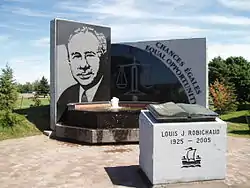 Louis J. Robichaud memorial | |
 Coat of arms | |
| Motto(s): "P'tite ville en campagne" | |
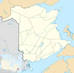 Saint-Antoine The location of Saint-Antoine within New Brunswick. | |
| Coordinates: 46.36286°N 64.75260°W | |
| Country | |
| Province | New Brunswick |
| County | Kent County |
| Founded | 1832 |
| Incorporated | November 9, 1966 |
| Government | |
| • Mayor | Ricky Gautreau |
| • Governing Body | Saint-Antoine Village Council |
| Area | |
| • Total | 6.32 km2 (2.44 sq mi) |
| Population (2016)[1] | |
| • Total | 1,733 |
| • Density | 274.3/km2 (710/sq mi) |
| Time zone | UTC−4 (AST) |
| • Summer (DST) | UTC−3 (ADT) |
| Area code(s) | 506 |
History
The village is named in honour of Anthony the Great. From 1966, it was called St. Anthony until it was changed to Saint-Antoine in 1969. The village was originally called Higho Settlement. Saint-Antoine was the birthplace of Louis Robichaud, Canada's first elected Acadian provincial premier.
Demographics
|
Religious make-up (2001)
|
Income (2006)
|
Mother tongue (2011)[3]
|
Notable people
See also
References
- "Census Profile, 2016 Census Saint-Antoine, Village [Census subdivision], New Brunswick". Statistics Canada. Retrieved September 13, 2019.
- Statistics Canada: 1996, 2001, 2006 census
- Statistics Canada: 2011 census
External links
This article is issued from Wikipedia. The text is licensed under Creative Commons - Attribution - Sharealike. Additional terms may apply for the media files.
