List of listed buildings in Biggar, South Lanarkshire
List
| Name | Location | Date Listed | Grid Ref. [note 1] | Geo-coordinates | Notes | LB Number [note 2] | Image |
|---|---|---|---|---|---|---|---|
| 4 Kirkstyle | 55°37′28″N 3°31′31″W | Category B | 22253 |  | |||
| 8 Kirkstyle | 55°37′28″N 3°31′31″W | Category C(S) | 22255 | | |||
| Moat Park Church Kirkstyle | 55°37′29″N 3°31′35″W | Category B | 22259 | | |||
| 27 And 29 High Street | 55°37′23″N 3°31′37″W | Category C(S) | 22176 | | |||
| 55 High Street | 55°37′25″N 3°31′34″W | Category C(S) | 22185 | | |||
| Part Of 81 High Street, & 83 High Street, In Wynd To Rear | 55°37′29″N 3°31′28″W | Category C(S) | 22196 | | |||
| 97 & 99 High Street | 55°37′28″N 3°31′25″W | Category C(S) | 22199 | | |||
| 105 & 107 High Street | 55°37′29″N 3°31′24″W | Category B | 22200 | | |||
| Crown Hotel, (109 & 111) High Street | 55°37′29″N 3°31′24″W | Category B | 22201 | | |||
| 125, 127 And 129 High Street | 55°37′29″N 3°31′22″W | Category B | 22202 | | |||
| 135 High Street (At Rear Of 133) (Smith's Close) | 55°37′29″N 3°31′21″W | Category C(S) | 22204 | | |||
| Elphinstone Hotel, High Street | 55°37′30″N 3°31′18″W | Category B | 22207 | | |||
| 169 High Street | 55°37′30″N 3°31′16″W | Category C(S) | 22213 | | |||
| 213 High Street | 55°37′33″N 3°31′11″W | Category C(S) | 22217 | | |||
| 10, 12 And 14 High Street | 55°37′21″N 3°31′38″W | Category C(S) | 22222 | | |||
| 94 & 96 High Street | 55°37′27″N 3°31′24″W | Category C(S) | 22233 | | |||
| Braebourne 182 High Street | 55°37′33″N 3°31′09″W | Category B | 22248 | | |||
| Lindsaylands | 55°37′12″N 3°32′47″W | Category B | 6461 | | |||
| Biggar Park South Lodge, Including Walls, Gatepiers And Railings | 55°37′05″N 3°32′10″W | Category C(S) | 5100 | | |||
| Station Road, Former Railway Station, Including Principal Building With Wash House, Signal Box, Outbuilding And Goods Shed | 55°37′10″N 3°31′36″W | Category B | 44553 | 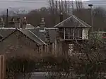 | |||
| St Mary's Church Kirkstyle | 55°37′30″N 3°31′31″W | Category A | 22257 | 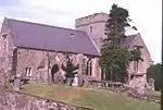 | |||
| St Mary's Church-Graveyard Kirkstyle | 55°37′31″N 3°31′31″W | Category B | 22258 | | |||
| Kirkhouse, Carwood Road | 55°37′40″N 3°31′33″W | Category B | 22269 | | |||
| Station Road, 1 And 2 Station Cottages | 55°37′10″N 3°31′41″W | Category C(S) | 22270 | | |||
| The Camb 4 Coulter Road | 55°37′18″N 3°31′46″W | Category B | 22169 | | |||
| 25. High Street | 55°37′22″N 3°31′38″W | Category C(S) | 22175 | | |||
| 43. High Street | 55°37′23″N 3°31′36″W | Category B | 22179 | | |||
| 51A High Street | 55°37′25″N 3°31′35″W | Category C(S) | 22184 | | |||
| 61 High Street (Manse) | 55°37′27″N 3°31′36″W | Category C(S) | 22187 | | |||
| 63 & 65 High Street | 55°37′26″N 3°31′31″W | Category C(S) | 22188 | | |||
| 32 High Street | 55°37′23″N 3°31′34″W | Category B | 22226 | | |||
| 74, 76 & 78 High Street | 55°37′26″N 3°31′26″W | Category C(S) | 22230 | | |||
| 98 & 100 High Street | 55°37′27″N 3°31′23″W | Category C(S) | 22234 | | |||
| Royal Bank Of Scotland 104 High Street | 55°37′27″N 3°31′23″W | Category B | 22235 | | |||
| 164 And 166 High Street | 55°37′30″N 3°31′10″W | Category C(S) | 22244 | | |||
| High House Of Edmonston | 55°39′50″N 3°28′45″W | Category B | 636 | | |||
| Edmonston | 55°39′53″N 3°28′40″W | Category B | 637 | | |||
| 2 North Back Road | 55°37′28″N 3°31′31″W | Category C(S) | 22260 | | |||
| 71 High Street | 55°37′27″N 3°31′29″W | Category C(S) | 22190 | | |||
| 85 & 87 High Street | 55°37′28″N 3°31′27″W | Category C(S) | 22197 | | |||
| 131 And 133 High Street | 55°37′29″N 3°31′21″W | Category B | 22203 | | |||
| Fleming Arms, High Street | 55°37′30″N 3°31′20″W | Category B | 22206 | | |||
| 153 High Street | 55°37′30″N 3°31′18″W | Category C(S) | 22209 | | |||
| 205 High Street | 55°37′32″N 3°31′12″W | Category C(S) | 22215 | | |||
| 8 High Street | 55°37′20″N 3°31′39″W | Category B | 22221 | | |||
| 80, 82 & 84 High Street | 55°37′26″N 3°31′25″W | Category C(S) | 22231 | | |||
| 86 & 88 High Street | 55°37′27″N 3°31′25″W | Category C(S) | 22232 | | |||
| Buildings To Rear Of 136, 138 High Street | 55°37′28″N 3°31′15″W | Category C(S) | 22241 | | |||
| 162 High Street | 55°37′30″N 3°31′10″W | Category C(S) | 22243 | | |||
| 168 High Street | 55°37′31″N 3°31′10″W | Category C(S) | 22245 | | |||
| Cormiston House And Steading | 55°37′10″N 3°34′24″W | Category B | 6585 | | |||
| Lindsaylands, Lodge And Gatepiers | 55°37′11″N 3°32′32″W | Category B | 6462 | | |||
| Lindsaylands, Stables | 55°37′14″N 3°32′46″W | Category B | 6463 | | |||
| Brownsbank Cottage | 55°39′41″N 3°28′19″W | Category A | 640 | | |||
| Building At Rear Of Brookside, The Wynd, | 55°37′29″N 3°31′42″W | Category C(S) | 22266 | | |||
| 8 The Wynd | 55°37′22″N 3°31′42″W | Category C(S) | 22267 | | |||
| 37 And 39 High Street | 55°37′23″N 3°31′36″W | Category B | 22178 | | |||
| 57 High Street | 55°37′25″N 3°31′33″W | Category C(S) | 22186 | | |||
| 77 & 79 High Street | 55°37′28″N 3°31′28″W | Category C(S) | 22193 | | |||
| Part Of 81 High Street, In Wynd To Rear | 55°37′29″N 3°31′28″W | Category B | 22195 | | |||
| 20 High Street | 55°37′21″N 3°31′37″W | Category C(S) | 22224 | | |||
| 34 And 36 High Street | 55°37′23″N 3°31′34″W | Category C(S) | 22227 | | |||
| 116, 118 & 120 High Street | 55°37′28″N 3°31′20″W | Category C(S) | 22239 | | |||
| 7 Kirkstyle | 55°37′26″N 3°31′33″W | Category C(S) | 22251 | | |||
| 2 Kirkstyle | 55°37′28″N 3°31′31″W | Category B | 22252 | | |||
| Biggar Mill And Millhouse | 55°37′36″N 3°31′39″W | Category B | 6371 | | |||
| Langlees Road, Langlees House And Lodge | 55°37′30″N 3°32′29″W | Category B | 5101 | | |||
| 6 Kirkstyle | 55°37′28″N 3°31′31″W | Category B | 22254 | | |||
| 16 South Back Road | 55°37′26″N 3°31′16″W | Category C(S) | 22261 | | |||
| 5 Smiths Close | 55°37′30″N 3°31′21″W | Category C(S) | 22263 | | |||
| 4 James Square Smiths Close | 55°37′30″N 3°31′22″W | Category C(S) | 22264 | | |||
| 2, Gasworks Road | 55°37′24″N 3°31′39″W | Category A | 22171 | | |||
| Cadger's Brig High Street | 55°37′21″N 3°31′41″W | Category A | 22173 | 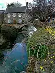 | |||
| 33 And 35 High Street | 55°37′23″N 3°31′36″W | Category B | 22177 | | |||
| 45. High Street | 55°37′24″N 3°31′35″W | Category B | 22180 | | |||
| 47. High Street | 55°37′24″N 3°31′34″W | Category B | 22181 | | |||
| Gable End Between Elphinstone Hotel And 153 High Street | 55°37′30″N 3°31′19″W | Category C(S) | 22208 | | |||
| 165 High Street | 55°37′30″N 3°31′16″W | Category B | 22212 | | |||
| 201 High Street | 55°37′32″N 3°31′12″W | Category C(S) | 22214 | | |||
| 207, 209 High Street | 55°37′32″N 3°31′11″W | Category C(S) | 22216 | | |||
| 215 High Street | 55°37′33″N 3°31′11″W | Category B | 22218 | | |||
| 30 High Street | 55°37′22″N 3°31′35″W | Category B | 22225 | | |||
| 180 High Street | 55°37′32″N 3°31′09″W | Category C(S) | 22247 | | |||
| Biggar Park Mansion House | 55°37′07″N 3°32′19″W | Category B | 5098 | | |||
| Boghall Castle | 55°37′01″N 3°31′29″W | Category B | 635 | | |||
| 24 South Back Road | 55°37′25″N 3°31′24″W | Category B | 22262 | | |||
| 49. High Street | 55°37′24″N 3°31′34″W | Category B | 22182 | | |||
| 69 High Street | 55°37′27″N 3°31′31″W | Category C(S) | 22189 | | |||
| 73 High Street | 55°37′27″N 3°31′29″W | Category C(S) | 22191 | | |||
| 89, 91 & 93 High Street | 55°37′28″N 3°31′26″W | Category B | 22198 | | |||
| 155 High Street | 55°37′30″N 3°31′18″W | Category B | 22210 | | |||
| 72 High Street | 55°37′26″N 3°31′28″W | Category B | 22229 | | |||
| 114 High Street | 55°37′28″N 3°31′21″W | Category C(S) | 22237 | | |||
| Doocot At Rear Of 116 - 120 High Street | 55°37′26″N 3°31′20″W | Category C(S) | 22238 | | |||
| 160 High Street | 55°37′30″N 3°31′11″W | Category C(S) | 22242 | | |||
| Biggar Park, Stables And Outbuildings | 55°37′05″N 3°32′23″W | Category B | 5099 | | |||
| Carwood House | 55°38′42″N 3°31′47″W | Category B | 639 | | |||
| Building To Rear Of 8 The Wynd | 55°37′23″N 3°31′42″W | Category C(S) | 22268 | | |||
| Crosskeys Hotel, High Street | 55°37′22″N 3°31′40″W | Category C(S) | 22174 | | |||
| Davaar, High Street | 55°37′28″N 3°31′29″W | Category B | 22192 | | |||
| 81 High Street | 55°37′28″N 3°31′27″W | Category B | 22194 | | |||
| 137 And 139 High Street | 55°37′29″N 3°31′20″W | Category C(S) | 22205 | | |||
| 219 High Street | 55°37′33″N 3°31′10″W | Category B | 22219 | | |||
| 16 High Street | 55°37′21″N 3°31′38″W | Category C(S) | 22223 | | |||
| Royal Bank Of Scotland 58 High Street | 55°37′25″N 3°31′31″W | Category C(S) | 22228 | | |||
| 178 High Street | 55°37′32″N 3°31′09″W | Category C(S) | 22246 | | |||
| Mossdale, 184 High Street | 55°37′33″N 3°31′09″W | Category B | 22249 | | |||
| Ross Square At Rear Of 182 High Street | 55°37′32″N 3°31′09″W | Category C(S) | 22250 | | |||
| Edmonston Mill | 55°39′36″N 3°28′26″W | Category B | 638 | | |||
| Church Hall, Kirkstyle | 55°37′28″N 3°31′33″W | Category C(S) | 22256 | | |||
| Brookside, The Wynd | 55°37′22″N 3°31′42″W | Category C(S) | 22265 | | |||
| Gas Showrooms, Gasworks Road | 55°37′24″N 3°31′40″W | Category A | 22170 | 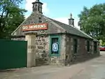 | |||
| Biggar Gasworks | 55°37′24″N 3°31′41″W | Category A | 22172 | 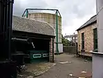 | |||
| 51. High Street | 55°37′24″N 3°31′35″W | Category B | 22183 | | |||
| 161 And 163 High Street | 55°37′30″N 3°31′17″W | Category C(S) | 22211 | | |||
| 2, 4 And 6 High Street | 55°37′20″N 3°31′39″W | Category B | 22220 | | |||
| 110 High Street | 55°37′27″N 3°31′21″W | Category C(S) | 22236 | | |||
| Biggar Corn Exchange, High Street | 55°37′28″N 3°31′18″W | Category B | 22240 | |
Key
The scheme for classifying buildings in Scotland is:
- Category A: "buildings of national or international importance, either architectural or historic; or fine, little-altered examples of some particular period, style or building type."[1]
- Category B: "buildings of regional or more than local importance; or major examples of some particular period, style or building type, which may have been altered."[1]
- Category C: "buildings of local importance; lesser examples of any period, style, or building type, as originally constructed or moderately altered; and simple traditional buildings which group well with other listed buildings."[1]
In March 2016 there were 47,288 listed buildings in Scotland. Of these, 8% were Category A, and 50% were Category B, with the remaining 42% being Category C.[2]
Notes
- Sometimes known as OSGB36, the grid reference (where provided) is based on the British national grid reference system used by the Ordnance Survey.
• "Guide to National Grid". Ordnance Survey. Retrieved 12 December 2007.
• "Get-a-map". Ordnance Survey. Retrieved 17 December 2007. - Historic Environment Scotland assign a unique alphanumeric identifier to each designated site in Scotland, for listed buildings this always begins with "LB", for example "LB12345".
References
- All entries, addresses and coordinates are based on data from Historic Scotland. This data falls under the Open Government Licence
- "What is Listing?". Historic Environment Scotland. Retrieved 29 May 2018.
- Scotland's Historic Environment Audit 2016 (PDF). Historic Environment Scotland and the Built Environment Forum Scotland. pp. 15–16. Retrieved 29 May 2018.
This article is issued from Wikipedia. The text is licensed under Creative Commons - Attribution - Sharealike. Additional terms may apply for the media files.