List of listed buildings in Lanark, South Lanarkshire
List
| Name | Location | Date Listed | Grid Ref. [note 1] | Geo-coordinates | Notes | LB Number [note 2] | Image |
|---|---|---|---|---|---|---|---|
| Bankhead Farm, Including Farmhouse, Steading And Boundary Walls | 55°39′56″N 3°46′33″W | Category C(S) | 43024 |  | |||
| New Lanark, Mill No 1 | 55°39′49″N 3°46′58″W | Category A | 37051 | 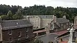 | |||
| New Lanark, Scottish Wildlife Trust Visitor Centre (Former Foundry, Later Dyeworks) | 55°39′42″N 3°46′49″W | Category A | 37055 | | |||
| Sisters Of Charity Convent, St Vincent Place | 55°40′22″N 3°46′23″W | Category C(S) | 37063 | | |||
| Gates To St Mary's Precinct, St Vincent Place | 55°40′22″N 3°46′22″W | Category C(S) | 37064 | | |||
| 2 And 4 Wellgate, Clydesdale Bank | 55°40′24″N 3°46′48″W | Category C(S) | 37071 | | |||
| 16 And 18 Wellgate | 55°40′23″N 3°46′46″W | Category C(S) | 37075 | | |||
| 20-26 (Even Numbers Only) Wellgate | 55°40′23″N 3°46′46″W | Category C(S) | 37076 | | |||
| 7 West Port | 55°40′26″N 3°46′59″W | Category C(S) | 37086 | | |||
| 39 West Port | 55°40′27″N 3°47′04″W | Category C(S) | 37090 | | |||
| 25, 27, 29 High Street | 55°40′26″N 3°46′46″W | Category C(S) | 36987 | | |||
| 47 And 49 High Street | 55°40′25″N 3°46′44″W | Category C(S) | 36993 | | |||
| 4, 6, 8 And 10 Hope Street | 55°40′27″N 3°46′54″W | Category C(S) | 37012 | | |||
| 1 And 3 Hyndford Place | 55°40′24″N 3°46′50″W | Category C(S) | 37019 | | |||
| Cemetery Chapel, Hyndford Road | 55°40′10″N 3°46′06″W | Category A | 37029 | 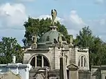 | |||
| New Lanark Road, Braxfield House, Stables | 55°40′08″N 3°47′15″W | Category B | 37036 | | |||
| New Lanark 1-10 (Inclusive Nos) Braxfield Row | 55°39′54″N 3°47′02″W | Category A | 37038 | | |||
| New Lanark, 9-16 (Inclusive Nos) Caithness Row With Garages (Former Abattoir) | 55°39′45″N 3°46′46″W | Category A | 37040 | | |||
| New Lanark, 1-14 (Inclusive Nos) Long Row | 55°39′53″N 3°47′01″W | Category A | 37043 | | |||
| New Lanark, New Buildings | 55°39′50″N 3°46′52″W | Category A | 37045 | 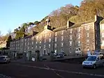 | |||
| 19 And 21 Bannatyne Street | 55°40′26″N 3°46′29″W | Category C(S) | 36927 | | |||
| 4 And 6 Bloomgate | 55°40′26″N 3°46′50″W | Category B | 36937 | | |||
| 4-16 (Even Nos Only) Broomgate | 55°40′25″N 3°46′52″W | Category C(S) | 36951 | | |||
| 13 & 15 Castlegate | 55°40′24″N 3°46′49″W | Category C(S) | 36966 | | |||
| 56 And 58 Castlegate | 55°40′19″N 3°46′57″W | Category C(S) | 36973 | | |||
| St Nicholas Parish Church High Street | 55°40′25″N 3°46′50″W | Category B | 36981 | 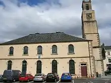 | |||
| Baronald (Cartland Bridge Hotel), Stable Block And Walled Garden | 55°40′51″N 3°47′38″W | Category C(S) | 13344 | | |||
| Road To Bonnington Mains And Robbiesland, Cast-Iron Bridge, Over Former Lanark-Muirkirk Railway | 55°39′47″N 3°45′06″W | Category B | 13069 | | |||
| New Lanark, Water Houses | 55°39′48″N 3°46′59″W | Category A | 46471 | | |||
| Hyndford Road, Former Lady Hozier Convalescent Home And Boundary Walls | 55°40′12″N 3°45′45″W | Category C(S) | 47972 | | |||
| 46A, 48 And 48A Bannatyne Street, Lanark Bingo, Former Regal Cinema And Shops | 55°40′23″N 3°46′26″W | Category C(S) | 51103 | | |||
| New Lanark, Education Centre (Formerly The School) | 55°39′45″N 3°46′49″W | Category A | 37050 | 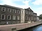 | |||
| 2 Park Place | 55°40′32″N 3°47′10″W | Category B | 37060 | | |||
| St Mary's Rc Church, St Vincent Place | 55°40′20″N 3°46′24″W | Category A | 37062 | .jpg.webp) | |||
| St Mary's Church Hall, St Vincent Place | 55°40′21″N 3°46′25″W | Category A | 37065 | | |||
| 6-8 Wellgate | 55°40′24″N 3°46′47″W | Category B | 37072 | | |||
| 10 Wellgate | 55°40′24″N 3°46′47″W | Category C(S) | 37073 | | |||
| 28 And 30 Wellgate | 55°40′23″N 3°46′45″W | Category C(S) | 37077 | | |||
| 34 And 36 Wellgate | 55°40′22″N 3°46′45″W | Category B | 37079 | | |||
| 42 Wellgate | 55°40′22″N 3°46′44″W | Category C(S) | 37081 | | |||
| 44-48(Even Numbers Only) Wellgate | 55°40′22″N 3°46′44″W | Category B | 37082 | | |||
| 28 Wellgate Head | 55°40′19″N 3°46′36″W | Category C(S) | 37085 | | |||
| 9, 11 And 13 West Port | 55°40′26″N 3°47′00″W | Category B | 37087 | | |||
| 20 West Port | 55°40′28″N 3°47′01″W | Category C(S) | 37092 | | |||
| New Lanark, New Lanark Road, K6 Telephone Kiosk | 55°39′50″N 3°46′53″W | Category B | 37104 | | |||
| 19, 21 And 23 High Street | 55°40′25″N 3°46′47″W | Category C(S) | 36986 | | |||
| 18 And 20 High Street | 55°40′24″N 3°46′45″W | Category C(S) | 36999 | | |||
| 25 Hope Street | 55°40′31″N 3°46′54″W | Category B | 37010 | | |||
| Hope Bank 18 Hope Street | 55°40′29″N 3°46′53″W | Category C(S) | 37014 | | |||
| Hyndford Road, Gates, Gatepiers And Railings At Auction Room And Cattle Market | 55°40′14″N 3°46′05″W | Category A | 37024 | | |||
| 2Nd Auction Room And Hyndford Road Auction Market | 55°40′16″N 3°46′14″W | Category C(S) | 37025 | | |||
| Mousemill Road, Clydesholm Bridge | 55°40′32″N 3°48′02″W | Category A | 37032 | 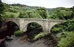 | |||
| 1A, Old Bridgend, Kirkfieldbank | 55°40′34″N 3°47′59″W | Category C(S) | 37033 | | |||
| New Lanark, 1-8 (Inclusive Nos) Caithness Row And The Counting House | 55°39′47″N 3°46′47″W | Category A | 37039 | | |||
| New Lanark, Rosedale Street, 5-12 (Inclusive Nos) Double Row, Known As Water Row | 55°39′52″N 3°47′00″W | Category A | 37042 | | |||
| New Lanark, 1-11 (Inclusive Nos) Nursery Buildings | 55°39′48″N 3°46′48″W | Category A | 37046 | | |||
| 52 Bloomgate | 55°40′27″N 3°46′56″W | Category B | 36946 | | |||
| 28 And 30 Broomgate | 55°40′24″N 3°46′53″W | Category B | 36952 | | |||
| 32 Broomgate | 55°40′23″N 3°46′54″W | Category B | 36953 | | |||
| 38 Broomgate | 55°40′23″N 3°46′54″W | Category B | 36955 | | |||
| 40 Broomgate | 55°40′23″N 3°46′55″W | Category C(S) | 36956 | | |||
| 53 And 55 Castlegate | 55°40′21″N 3°46′53″W | Category C(S) | 36970 | | |||
| 7, 9 And 13 High Street | 55°40′25″N 3°46′48″W | Category C(S) | 36984 | | |||
| Cartland Bridge | 55°40′50″N 3°48′03″W | Category B | 13054 | | |||
| Orchard Dell, Now Sorisdale | 55°40′44″N 3°48′05″W | Category B | 13063 | | |||
| 86 Mousebank Road, Ridge Park Home Including Walled Garden And Conservatory | 55°40′51″N 3°47′12″W | Category B | 13066 | | |||
| Bonnington Linn, Footbridge | 55°38′47″N 3°46′31″W | Category B | 46900 | | |||
| Falls Of Clyde, Stonebyres Power Station With Tank And Pipes | 55°40′38″N 3°49′48″W | Category A | 51719 | | |||
| 7 North Vennel | 55°40′28″N 3°46′57″W | Category C(S) | 37057 | | |||
| Lanark Memorial Hall, St Leonard Street | 55°40′28″N 3°46′31″W | Category B | 37061 | | |||
| St Mary's Presbytery St Vincent Place | 55°40′20″N 3°46′22″W | Category A | 37066 | | |||
| 13, 15 And 17 Wellgate Head | 55°40′20″N 3°46′36″W | Category C(S) | 37084 | | |||
| 35 And 37 West Port | 55°40′27″N 3°47′02″W | Category C(S) | 37088 | | |||
| Eu Church West Port | 55°40′27″N 3°47′04″W | Category C(S) | 37089 | | |||
| 22 West Port | 55°40′28″N 3°47′02″W | Category C(S) | 37093 | | |||
| Wheatpark Cottage, 5 Wheatpark Road | 55°40′35″N 3°47′00″W | Category B | 37098 | | |||
| Smyllum Park, Whitelees Road | 55°40′24″N 3°45′40″W | Category B | 37101 | | |||
| 43 And 45 High Street D W Brown And Son | 55°40′25″N 3°46′44″W | Category C(S) | 36992 | | |||
| 14 And 16 High Street | 55°40′24″N 3°46′46″W | Category B | 36998 | | |||
| 13 Hope Street Mervyn | 55°40′29″N 3°46′55″W | Category C(S) | 37006 | | |||
| 6 Market End | 55°40′23″N 3°46′52″W | Category C(S) | 37031 | | |||
| New Lanark Road, Braxfield House | 55°40′08″N 3°47′20″W | Category B | 37035 | | |||
| New Lanark, Community Hall (Former New Lanark Church) With Gatepiers, Railings And Boundary Walls | 55°39′52″N 3°46′54″W | Category A | 37037 | 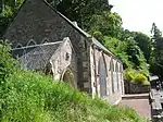 | |||
| 12, 14, 16 Bloomgate | 55°40′26″N 3°46′51″W | Category C(S) | 36939 | | |||
| 30 And 32 Bloomgate | 55°40′26″N 3°46′53″W | Category B | 36941 | | |||
| 42 Bloomgate | 55°40′26″N 3°46′54″W | Category C(S) | 36943 | | |||
| 48 Bloomgate | 55°40′27″N 3°46′56″W | Category C(S) | 36945 | | |||
| Castlepark Lodge Broomgate | 55°40′18″N 3°47′00″W | Category B | 36958 | | |||
| 9 & 11 Castlegate | 55°40′24″N 3°46′49″W | Category C(S) | 36965 | | |||
| 38 Castlegate | 55°40′21″N 3°46′55″W | Category B | 36969 | | |||
| 101 Castlegate | 55°40′15″N 3°47′01″W | Category B | 36975 | | |||
| Former Tollhouse, 201 Hyndford Road | 55°39′52″N 3°44′56″W | Category B | 13469 | | |||
| The Lee, South Lodge | 55°40′50″N 3°48′20″W | Category B | 13058 | | |||
| Mousemill House | 55°40′40″N 3°47′59″W | Category C(S) | 13062 | 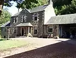 | |||
| 64, 66 Hall Road, Nemphlar | 55°40′47″N 3°49′19″W | Category B | 13068 | | |||
| New Lanark, Visitor Centre (Formerly New Institution For The Formation Of Character And Engine House) | 55°39′48″N 3°46′51″W | Category A | 37049 | 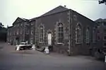 | |||
| New Lanark, Mill No 3 | 55°39′48″N 3°46′55″W | Category A | 37053 | | |||
| New Lanark, Former Mechanics' Workshop | 55°39′42″N 3°46′48″W | Category A | 37054 | 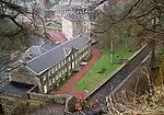 | |||
| 11 North Vennel | 55°40′28″N 3°46′57″W | Category C(S) | 37059 | | |||
| 39 Wellgate | 55°40′23″N 3°46′43″W | Category B | 37069 | | |||
| 32 Wellgate | 55°40′23″N 3°46′45″W | Category C(S) | 37078 | | |||
| 50 Wellgate | 55°40′22″N 3°46′43″W | Category B | 37083 | | |||
| 28 West Port | 55°40′28″N 3°47′02″W | Category C(S) | 37095 | | |||
| Gatepiers, 52 Wheatpark Road | 55°40′31″N 3°47′09″W | Category B | 37100 | | |||
| Chapel, Smyllum Park, Whitelees Road | 55°40′24″N 3°45′41″W | Category B | 37102 | | |||
| Institute Smyllum Park, Whitelees Road | 55°40′25″N 3°45′37″W | Category B | 37103 | | |||
| 51 High Street | 55°40′25″N 3°46′43″W | Category C(S) | 36994 | | |||
| The Portvaults Public House 116 High Street | 55°40′25″N 3°46′33″W | Category C(S) | 37001 | | |||
| 20 Hope Street | 55°40′29″N 3°46′53″W | Category B | 37015 | | |||
| Hyndford Road Auction Room Cattle Market | 55°40′15″N 3°46′09″W | Category B | 37023 | | |||
| New Lanark, 5 And 7 Rosedale Street, David Dale's House | 55°39′51″N 3°46′56″W | Category A | 37048 |  | |||
| Ymca Bloomgate | 55°40′26″N 3°46′57″W | Category B | 36935 | | |||
| 8 And 10 Bloomgate | 55°40′26″N 3°46′50″W | Category B | 36938 | | |||
| 5 Broomgate | 55°40′25″N 3°46′51″W | Category C(S) | 36948 | | |||
| Wampherflatt Braxfield Road | 55°40′15″N 3°46′38″W | Category B | 36960 | | |||
| Hyndford Bridge | 55°39′16″N 3°43′35″W | Category A | 13055 | 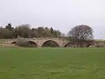 | |||
| The Lee | 55°41′55″N 3°49′29″W | Category B | 13056 | | |||
| Baronald (Cartland Bridge Hotel) | 55°40′55″N 3°47′35″W | Category A | 12967 | | |||
| Bonnington Mains | 55°39′31″N 3°45′47″W | Category B | 51427 | | |||
| Mansefield House, West Port | 55°40′30″N 3°47′02″W | Category B | 37096 | | |||
| 7 Hope Street | 55°40′27″N 3°46′55″W | Category C(S) | 37004 | | |||
| Hope Street Former Council Chambers Clerk's Office And Sheriff Court | 55°40′30″N 3°46′52″W | Category B | 37016 | | |||
| Hope Street Christ Church Episcopal Church | 55°40′32″N 3°46′51″W | Category B | 37018 | | |||
| Hyndford House 5 Hyndford Place | 55°40′24″N 3°46′51″W | Category B | 37020 | | |||
| 5 And 7 Hyndford Road | 55°40′19″N 3°46′30″W | Category B | 37022 | | |||
| 1 New Lanark Road | 55°39′58″N 3°46′31″W | Category B | 37034 | | |||
| New Lanark, Rosedale Street, 1- 4 (Inclusive Nos) Double Row, Also Known As Wee Row | 55°39′51″N 3°46′58″W | Category A | 37041 | 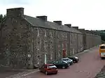 | |||
| Clydesdale Hotel 13 & 15 Bloomgate | 55°40′25″N 3°46′53″W | Category B | 36933 | | |||
| Castle Park 80 Broomgate | 55°40′19″N 3°47′02″W | Category B | 36959 | | |||
| 54 Castlegate | 55°40′19″N 3°46′57″W | Category C(S) | 36972 | | |||
| 13 Friars Lane, Friarsview, Including Boundary Walls | 55°40′22″N 3°47′00″W | Category C(S) | 36980 | | |||
| 15 And 17 High Street Wrights | 55°40′26″N 3°46′47″W | Category C(S) | 36985 | | |||
| Hyndford Road, Lanark Racecourse, Tote Tower | 55°39′53″N 3°44′47″W | Category B | 46519 | | |||
| New Lanark Road, Braxfield House, Walled Garden | 55°40′00″N 3°47′25″W | Category C(S) | 51429 | | |||
| Falls Of Clyde, Stonebyres Power Station Weir And Bridge | 55°40′34″N 3°49′20″W | Category A | 51720 | | |||
| Falls Of Clyde, Bonnington Power Station Weir And Bridge | 55°40′34″N 3°49′20″W | Category A | 51728 | | |||
| New Lanark, Retort House Chimney | 55°39′40″N 3°46′50″W | Category A | 37056 | 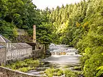 | |||
| 1 Wellgate | 55°40′24″N 3°46′47″W | Category B | 37067 | | |||
| 41, 43 And 45 Wellgate | 55°40′22″N 3°46′43″W | Category C(S) | 37070 | | |||
| 2 West Port | 55°40′27″N 3°46′58″W | Category B | 37091 | | |||
| 31 High Street | 55°40′25″N 3°46′46″W | Category C(S) | 36988 | | |||
| 37 And 39 High Street | 55°40′25″N 3°46′45″W | Category C(S) | 36990 | | |||
| Hope Street St Kentigern's Church (Church Of Scotland) | 55°40′29″N 3°46′55″W | Category B | 37007 | | |||
| Crown Tavern 17 Hope Street | 55°40′30″N 3°46′55″W | Category C(S) | 37008 | | |||
| Linsay Institute, Hope Street | 55°40′28″N 3°46′54″W | Category B | 37013 | | |||
| 12-22 (Even Nos) Lockhart Drive, Former William Smellie Memorial Hospital | 55°40′39″N 3°47′27″W | Category B | 37030 | | |||
| The Royal Oak Tree Bannatyne Street | 55°40′25″N 3°46′26″W | Category C(S) | 36928 | | |||
| 7 Bloomgate And 2 Broomgate | 55°40′25″N 3°46′52″W | Category C(S) | 36932 | | |||
| Cairns Church Of Scotland Bloomgate | 55°40′26″N 3°46′57″W | Category B | 36936 | | |||
| 18 And 20 Bloomgate | 55°40′26″N 3°46′52″W | Category C(S) | 36940 | | |||
| 36 Bloomgate | 55°40′26″N 3°46′54″W | Category C(S) | 36942 | | |||
| 44 And 46 Bloomgate | 55°40′27″N 3°46′56″W | Category B | 36944 | | |||
| 7 Broomgate | 55°40′24″N 3°46′51″W | Category C(S) | 36949 | | |||
| 34 And 36 Broomgate | 55°40′23″N 3°46′54″W | Category B | 36954 | | |||
| Castlegate, Lodge To Castlebank Park Including Boundary Walls, Gatepiers And Gates | 55°40′15″N 3°47′04″W | Category C(S) | 36976 | | |||
| Ryber Lodge, Cleghorn Road | 55°40′45″N 3°46′42″W | Category C(S) | 36979 | | |||
| The Lee, Dovecote | 55°41′49″N 3°49′30″W | Category B | 13057 | | |||
| Holmfoot | 55°42′01″N 3°51′53″W | Category B | 13059 | | |||
| The Roman Bridge | 55°40′41″N 3°47′58″W | Category B | 13061 | | |||
| Hyndford Road At A70, Winston Barracks, Officers' Mess | 55°39′48″N 3°43′47″W | Category C(S) | 46981 | | |||
| New Lanark Road, Braxfield House, Dairy | 55°40′08″N 3°47′17″W | Category C(S) | 51428 | | |||
| Falls Of Clyde, Bonnington Power Station With Tank And Pipes | 55°39′13″N 3°46′25″W | Category A | 51727 | | |||
| New Lanark, Weir, Tunnel And Lade | 55°39′33″N 3°46′48″W | Category A | 44552 | | |||
| 9 North Vennel | 55°40′28″N 3°46′57″W | Category C(S) | 37058 | | |||
| 3 And 5 Wellgate | 55°40′24″N 3°46′46″W | Category B | 37068 | | |||
| Wheatpark, Wheatpark Road | 55°40′34″N 3°47′03″W | Category B | 37097 | | |||
| 41 High Street | 55°40′25″N 3°46′45″W | Category C(S) | 36991 | | |||
| 61 High Street | 55°40′25″N 3°46′42″W | Category C(S) | 36996 | | |||
| Royal Bank Of Scotland 88 High Street | 55°40′24″N 3°46′37″W | Category C(S) | 37000 | | |||
| Crosslaw House, Home Street | 55°40′11″N 3°45′42″W | Category B | 37002 | | |||
| 5 Hope Street | 55°40′27″N 3°46′55″W | Category C(S) | 37003 | | |||
| 11 Hope Street | 55°40′28″N 3°46′55″W | Category B | 37005 | | |||
| Hope Street Former County Police Station | 55°40′31″N 3°46′51″W | Category B | 37017 | | |||
| 7-13 Hyndford Place (Odd Numbers Only) | 55°40′24″N 3°46′51″W | Category C(S) | 37021 | | |||
| Lanark Grammar School, Hyndford Road | 55°40′17″N 3°46′31″W | Category B | 37027 | | |||
| Railway Station, Bannatyne Street, Lanark, Including Platform Shelter | 55°40′25″N 3°46′23″W | Category B | 36930 | | |||
| Bank Of Scotland 21 Bloomgate | 55°40′26″N 3°46′55″W | Category C(S) | 36934 | | |||
| 54 Bloomgate | 55°40′27″N 3°46′57″W | Category B | 36947 | | |||
| Castlebank House, Including Stable Court Range | 55°40′16″N 3°47′17″W | Category B | 36961 | | |||
| Castlebar 32 & 34 Castlegate | 55°40′21″N 3°46′55″W | Category C(S) | 36967 | | |||
| 57 And 57A Castlegate | 55°40′21″N 3°46′53″W | Category C(S) | 36971 | | |||
| Greenside, Cleghorn Road, Lanark | 55°40′35″N 3°46′48″W | Category B | 36978 | | |||
| Mousemill Bridge | 55°40′41″N 3°48′00″W | Category B | 13060 | | |||
| Hyndford Road At A70, Winston Barracks, Accommodation Block | 55°39′42″N 3°43′49″W | Category B | 46978 | | |||
| Hyndford Road At A70, Winston Barracks, Sergeants' Mess | 55°39′40″N 3°43′44″W | Category B | 46982 | | |||
| 7 Wellgate | 55°40′24″N 3°46′46″W | Category C(S) | 49589 | | |||
| 2 New Lanark Road | 55°39′58″N 3°46′31″W | Category B | 51430 | | |||
| New Lanark, Mill No 2 | 55°39′48″N 3°46′56″W | Category A | 37052 | | |||
| 12 And 14 Wellgate, Maize's Bar | 55°40′24″N 3°46′47″W | Category C(S) | 37074 | | |||
| 38 And 40 Wellgate | 55°40′22″N 3°46′44″W | Category C(S) | 37080 | | |||
| 24 And 26 West Port | 55°40′28″N 3°47′02″W | Category C(S) | 37094 | | |||
| Former Lodge To Wheatpark, 52 Wheatpark Road | 55°40′32″N 3°47′08″W | Category B | 37099 | | |||
| 35 High Street | 55°40′25″N 3°46′45″W | Category C(S) | 36989 | | |||
| 57 High Street | 55°40′26″N 3°46′43″W | Category B | 36995 | | |||
| 2-8 High Street | 55°40′25″N 3°46′46″W | Category B | 36997 | | |||
| 21 Hope Street, Lanark, Including Boundary Walls And Railings | 55°40′30″N 3°46′54″W | Category C(S) | 37009 | | |||
| 35 Hope Street, Lanark, Including Outbuilding And Boundary Walls | 55°40′33″N 3°46′53″W | Category B | 37011 | | |||
| Muirglen, Hyndford Road | 55°40′13″N 3°45′50″W | Category C(S) | 37026 | | |||
| St Kentigern's Church, Hyndford Road | 55°40′12″N 3°46′11″W | Category B | 37028 | | |||
| New Lanark, 1 And 3 Rosedale Street, Robert Owen's House | 55°39′50″N 3°46′54″W | Category A | 37047 | 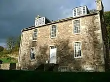 | |||
| The Caledonian Hotel Banatyne Street | 55°40′23″N 3°46′25″W | Category C(S) | 36929 | | |||
| 1, 3 And 5 Bloomgate | 55°40′25″N 3°46′51″W | Category C(S) | 36931 | | |||
| 9 Broomgate | 55°40′23″N 3°46′52″W | Category C(S) | 36950 | | |||
| Broomgate House, 42 And 44 Broomgate | 55°40′22″N 3°46′55″W | Category B | 36957 | | |||
| Castlebank House, Garden Terraces | 55°40′13″N 3°47′18″W | Category C(S) | 36962 | | |||
| 5 & 7 Castlegate | 55°40′24″N 3°46′49″W | Category C(S) | 36964 | | |||
| 36 Castlegate | 55°40′21″N 3°46′55″W | Category C(S) | 36968 | | |||
| 68 And 72 Castlegate | 55°40′18″N 3°46′58″W | Category C(S) | 36974 | | |||
| 1 High Street | 55°40′25″N 3°46′49″W | Category C(S) | 36982 | | |||
| 3 High Street, The Cross Cafe | 55°40′25″N 3°46′49″W | Category C(S) | 36983 | | |||
| Jerviswood | 55°41′25″N 3°46′38″W | Category A | 13053 | | |||
| Mouse Mill | 55°40′42″N 3°48′05″W | Category B | 13064 | | |||
| Corra Linn, Bonnington Pavilion | 55°39′14″N 3°46′26″W | Category A | 13065 | | |||
| Mousebank Road, Ridge Park Lodge And Gatepiers | 55°40′49″N 3°47′15″W | Category C(S) | 13067 | | |||
| Baronald Estate (Cartland Bridge Hotel), Lodge | 55°40′49″N 3°47′43″W | Category B | 12968 | | |||
| Hyndford Road At A70, Winston Barracks, Guardhouse And Museum, Including Gates, Gatepiers And Railings | 55°39′41″N 3°43′56″W | Category C(S) | 46979 | |
Key
The scheme for classifying buildings in Scotland is:
- Category A: "buildings of national or international importance, either architectural or historic; or fine, little-altered examples of some particular period, style or building type."[1]
- Category B: "buildings of regional or more than local importance; or major examples of some particular period, style or building type, which may have been altered."[1]
- Category C: "buildings of local importance; lesser examples of any period, style, or building type, as originally constructed or moderately altered; and simple traditional buildings which group well with other listed buildings."[1]
In March 2016 there were 47,288 listed buildings in Scotland. Of these, 8% were Category A, and 50% were Category B, with the remaining 42% being Category C.[2]
Notes
- Sometimes known as OSGB36, the grid reference (where provided) is based on the British national grid reference system used by the Ordnance Survey.
• "Guide to National Grid". Ordnance Survey. Retrieved 2007-12-12.
• "Get-a-map". Ordnance Survey. Retrieved 2007-12-17. - Historic Environment Scotland assign a unique alphanumeric identifier to each designated site in Scotland, for listed buildings this always begins with "LB", for example "LB12345".
References
- All entries, addresses and coordinates are based on data from Historic Scotland. This data falls under the Open Government Licence
- "What is Listing?". Historic Environment Scotland. Retrieved 29 May 2018.
- Scotland's Historic Environment Audit 2016 (PDF). Historic Environment Scotland and the Built Environment Forum Scotland. pp. 15–16. Retrieved 29 May 2018.
This article is issued from Wikipedia. The text is licensed under Creative Commons - Attribution - Sharealike. Additional terms may apply for the media files.