List of listed buildings in Rutherglen, South Lanarkshire
List
| Name | Location | Date Listed | Grid Ref. [note 1] | Geo-coordinates | Notes | LB Number [note 2] | Image |
|---|---|---|---|---|---|---|---|
| 1-5 (Inclusive Nos) Blairbeth Terrace And 76 Blairbeth Road | 55°48′56″N 4°12′12″W | Category B | 33703 | 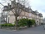 | |||
| 14 Burnside Road, The Ingle, Including Gateway, Quadrants, Piers, Gates, Railings, Coach House/Stable Block And Summer House | 55°48′44″N 4°12′01″W | Category B | 33704 | 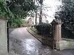 | |||
| 152, 154 Main Street, Rutherglen, Kirkwood Street, St Columbkille's RC Church And Presbytery | 55°49′39″N 4°12′50″W | Category A | 33567 | 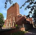 | |||
| King Street, Burgh Primary School With Boundary Walls, Railings And Gatepiers | 55°49′45″N 4°13′02″W | Category B | 50135 | _2016-02-28.jpg.webp) | |||
| 141 -147 (Odd Nos) Main Street, Rutherglen | 55°49′43″N 4°12′51″W | Category C(S) | 33565 | 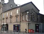 | |||
| Melrose Avenue, Rutherglen, Stonelaw High School (Main Block) | 55°49′31″N 4°12′34″W | Category B | 33568 | 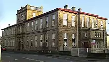 | |||
| Mill Street, Overtoun Park, Bandstand | 55°49′18″N 4°12′48″W | Category B | 33569 | 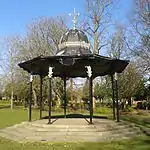 | |||
| Mill Street, Overtoun Park, Gateway | 55°49′22″N 4°12′58″W | Category B | 33570 | 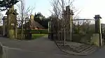 | |||
| 153 Stonelaw Road, Stonelaw Parish Church Including Gatepiers And Railings | 55°49′25″N 4°12′30″W | Category B | 33573 | 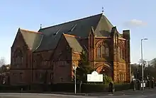 | |||
| 20-24 Queen Street And 115 King Street, Masonic Hall | 55°49′44″N 4°12′58″W | Category C(S) | 50134 | 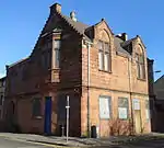 | |||
| 209 Main Street, Bower Bar | 55°49′44″N 4°12′42″W | Category C(S) | 50136 | _2018-03-24.jpg.webp) | |||
| 73 Blairbeth Road, Duncraggan, Including Gatepiers And Boundary Walls | 55°48′59″N 4°12′10″W | Category B | 33702 |  | |||
| 18 Farmeloan Road, Rutherglen, Former Rutherglen East Church | 55°49′44″N 4°12′36″W | Category B | 33554 | 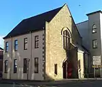 | |||
| Main Street Rutherglen, Mercat Cross | 55°49′43″N 4°12′48″W | Category C(S) | 33558 | 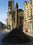 | |||
| 131, 139 Main Street, Rutherglen, District Council Offices (Originally Town Hall) | 55°49′43″N 4°12′53″W | Category A | 33564 | 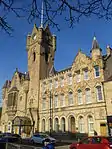 | |||
| Mill Street, Overtoun Park, Queen Victoria Jubilee Fountain | 55°49′19″N 4°12′48″W | Category B | 33571 | 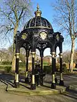 | |||
| 56,58 And 60 Main Street, Mecca Bingo (Former Vogue Cinema) | 55°49′40″N 4°13′02″W | Category C(S) | 50139 | _2016-02-28.jpg.webp) | |||
| 3 Western Avenue, Rutherglen West Parish Church (Munro Church) Church Of Scotland | 55°49′45″N 4°13′14″W | Category B | 33700 | 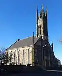 | |||
| Main Street Rutherglen, Old Parish Churchyard Including Kirk Port And Gateways | 55°49′42″N 4°12′57″W | Category B | 33561 | .jpg.webp) | |||
| 34 Broomieknow Road, Blairtum Park House Including Gatepiers | 55°49′01″N 4°12′39″W | Category C(S) | 33550 | 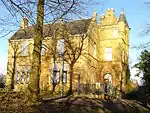 | |||
| Main Street Rutherglen, Queen Street Rutherglen Old Parish Church | 55°49′43″N 4°12′57″W | Category B | 33562 | 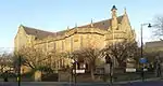 | |||
| 159, 161, 163 Main Street, Rutherglen, Post Office And Library | 55°49′43″N 4°12′50″W | Category B | 33566 |  | |||
| 53 Overtoun Drive, Mill Street, Overtoun Park, Superintendent's House | 55°49′21″N 4°12′55″W | Category B | 33572 | 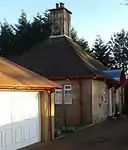 | |||
| Dalmarnock Road, Dalmarnock Bridge | 55°50′14″N 4°12′34″W | Category B | 33551 | 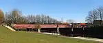 | |||
| Main Street, Rutherglen Tower And Fragments Of Old Church | 55°49′43″N 4°12′55″W | Category A | 33563 | 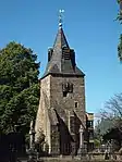 | |||
| 41 Dalmarnock Road, Rutherglen, And 1, 3 Baronald Street Including Tennents Bar | 55°50′01″N 4°12′28″W | Category C(S) | 33875 | _2016-02-28.jpg.webp) | |||
| 84, 86 Hamilton Road, Rutherglen, Cairn Hall | 55°49′35″N 4°12′23″W | Category C(S) | 33555 | 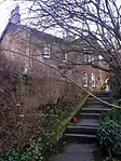 | |||
| Maccallum Avenue, Rutherglen, Stonelaw High School, Gallowflat Annexe (East Block) | 55°49′37″N 4°12′20″W | Category B | 33557 | | |||
| 63, 65 Main Street, Rutherglen, Narplan House | 55°49′43″N 4°13′02″W | Category C(S) | 33559 | 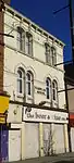 | |||
| Main Street, Rutherglen, Statue To Dr Gorman | 55°49′42″N 4°12′58″W | Category B | 33560 | 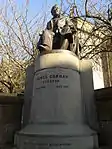 |
Key
The scheme for classifying buildings in Scotland is:
- Category A: "buildings of national or international importance, either architectural or historic; or fine, little-altered examples of some particular period, style or building type."[1]
- Category B: "buildings of regional or more than local importance; or major examples of some particular period, style or building type, which may have been altered."[1]
- Category C: "buildings of local importance; lesser examples of any period, style, or building type, as originally constructed or moderately altered; and simple traditional buildings which group well with other listed buildings."[1]
In March 2016 there were 47,288 listed buildings in Scotland. Of these, 8% were Category A, and 50% were Category B, with the remaining 42% being Category C.[2]
Notes
- Sometimes known as OSGB36, the grid reference (where provided) is based on the British national grid reference system used by the Ordnance Survey.
• "Guide to National Grid". Ordnance Survey. Retrieved 12 December 2007.
• "Get-a-map". Ordnance Survey. Retrieved 17 December 2007. - Historic Environment Scotland assign a unique alphanumeric identifier to each designated site in Scotland, for listed buildings this always begins with "LB", for example "LB12345".
References
- All entries, addresses and coordinates are based on data from Historic Scotland. This data falls under the Open Government Licence
- "What is Listing?". Historic Environment Scotland. Retrieved 29 May 2018.
- Scotland's Historic Environment Audit 2016 (PDF). Historic Environment Scotland and the Built Environment Forum Scotland. pp. 15–16. Retrieved 29 May 2018.
External links
- Listed Buildings in Rutherglen Central and North Ward, South Lanarkshire at British Listed Buildings
- Listed Buildings in Rutherglen South Ward, South Lanarkshire at British Listed Buildings
This article is issued from Wikipedia. The text is licensed under Creative Commons - Attribution - Sharealike. Additional terms may apply for the media files.