Loganville, Georgia
Loganville is a city in Walton and Gwinnett counties, Georgia, United States. The population was 10,458 at the 2010 census,[5] up from 5,435 in 2000.
Loganville, Georgia | |
|---|---|
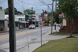 Downtown Loganville | |
| Motto(s): "Where people matter" | |
 Location in Walton County and the state of Georgia | |
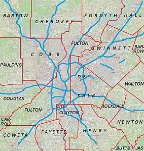 Loganville Location in Metro Atlanta | |
| Coordinates: 33°50′20″N 83°53′53″W | |
| Country | United States |
| State | Georgia |
| Counties | Walton, Gwinnett |
| Government | |
| • Mayor | Rey Martinez |
| Area | |
| • Total | 7.45 sq mi (19.29 km2) |
| • Land | 7.41 sq mi (19.18 km2) |
| • Water | 0.04 sq mi (0.12 km2) |
| Elevation | 1,001 ft (305 m) |
| Population (2010) | |
| • Total | 10,458 |
| • Estimate (2019)[2] | 12,880 |
| • Density | 1,739.37/sq mi (671.60/km2) |
| Time zone | UTC-5 (Eastern (EST)) |
| • Summer (DST) | UTC-4 (EDT) |
| ZIP code | 30052 |
| Area code(s) | 770 |
| FIPS code | 13-47196[3] |
| GNIS feature ID | 0356368[4] |
| Website | www |
History
An early variant name was "Buncombe".[6] The present name is after James Harvie Logan, an early settler.[7]
The Georgia General Assembly incorporated Loganville as a town in 1887.[8]
Geography
Loganville is in western Walton County, with the city limits extending west into southeastern Gwinnett County. U.S. Route 78 (Atlanta Highway) passes through the center of town, leading east 5 miles (8.0 km) to Monroe, the Walton County seat, and west 32 miles (51 km) to downtown Atlanta. Georgia State Route 20 leads northwest from Loganville 10 miles (16 km) to Lawrenceville, the Gwinnett County seat, and southwest 15 miles (24 km) to Conyers. Georgia State Route 81 leads northeast 16 miles (26 km) to Winder and south 18 miles (29 km) to Covington.
According to the United States Census Bureau, Loganville has a total area of 7.4 square miles (19.1 km2), of which 7.3 square miles (19.0 km2) is land and 0.04 square miles (0.1 km2), or 0.60%, is water.[5]
Demographics
| Historical population | |||
|---|---|---|---|
| Census | Pop. | %± | |
| 1880 | 242 | — | |
| 1890 | 338 | 39.7% | |
| 1900 | 431 | 27.5% | |
| 1910 | 600 | 39.2% | |
| 1920 | 711 | 18.5% | |
| 1930 | 631 | −11.3% | |
| 1940 | 627 | −0.6% | |
| 1950 | 699 | 11.5% | |
| 1960 | 926 | 32.5% | |
| 1970 | 1,318 | 42.3% | |
| 1980 | 1,841 | 39.7% | |
| 1990 | 3,180 | 72.7% | |
| 2000 | 5,435 | 70.9% | |
| 2010 | 10,458 | 92.4% | |
| 2019 (est.) | 12,880 | [2] | 23.2% |
| U.S. Decennial Census[9] | |||
As of the census of 2010, the population of Loganville was 10,458. The median age was 34.8. There were 3,825 households which represented a housing unit occupation rate of 91.6%. 69.6% of the occupied housing units were owner occupied.
The racial and ethnic composition of the population was 70.0% White, 22.1% Black, 0.3% Native American, 2.3% Asian, 0.1% Pacific Islander, 3.0% reporting some other race and 2.2% reporting two or more races. 6.8% of the population was Hispanic or Latino of any race.[10]
Education
Loganville is a part of the Walton County board of education. Loganville has a full complement of grade schools from primary to high school. Loganville High School recently moved into 8-AAAAA classification, based on student population.
Public schools
The following schools are part of the Walton County Public School System that serve the Loganville, Georgia area:
- Loganville High School (Loganville, GA)
- Walnut Grove High School (Loganville, GA)
- Performance Learning Center, duel enrollment school that serves Loganville High School and Monroe Area High School(Monroe, GA)
- Loganville Middle School (Loganville, GA)
- Youth Middle School (Loganville, GA)
- Loganville Elementary School (Loganville, GA)
- Youth Elementary School (Loganville, GA)
- Bay Creek Elementary School, formerly known as 'Loganville Primary School' (Loganville, GA)
- Walnut Grove Elementary School (Walnut Grove, GA)
- Sharon Elementary School (Loganville, GA)
- Blaine Street Elementary School (Monroe, GA) formally known as Monroe Primary School
The following schools are part of the Gwinnett County Public Schools System:
- Magill Elementary School
- Rosebud Elementary School
- Grace Snell Middle School
- McConnell Middle School (Loganville, GA)
- Grayson High School
Private schools
- Loganville Christian Academy
- Trinity Prep School
- Victory Baptist School
Points of interest
Notable people
- Bobby Byrd, singer in James Brown's band
- Kyle Chandler, actor
- Clint Frazier, Major League Baseball player
- Jon Langston, country singer
- Austin Meadows, Major League Baseball player
- Brandon Moss, Major League Baseball player
- Jordan Pruitt, pop singer
- Jeffrey Webb, former president of CONCACAF who was arrested in the 2015 FIFA corruption case in May 2015
- Wayne Gallman, NFL running back for the New York Giants
- Jordan Rager, country singer
References
- "2019 U.S. Gazetteer Files". United States Census Bureau. Retrieved July 9, 2020.
- "Population and Housing Unit Estimates". United States Census Bureau. May 24, 2020. Retrieved May 27, 2020.
- "U.S. Census website". United States Census Bureau. Retrieved 2008-01-31.
- "US Board on Geographic Names". United States Geological Survey. 2007-10-25. Retrieved 2008-01-31.
- "Geographic Identifiers: 2010 Demographic Profile Data (G001): Loganville city, Georgia". American Factfinder. U.S. Census Bureau. Retrieved November 30, 2016.
- U.S. Geological Survey Geographic Names Information System: Loganville, Georgia
- Krakow, Kenneth K. (1975). Georgia Place-Names: Their History and Origins (PDF). Macon, GA: Winship Press. p. 135. ISBN 0-915430-00-2.
- Acts Passed by the General Assembly of Georgia. J. Johnston. 1887. p. 508.
- "Census of Population and Housing". Census.gov. Retrieved June 4, 2015.
- 2010 general profile of population and housing characteristics for Loganville from the US Census.
External links
| Wikimedia Commons has media related to Loganville, Georgia. |
Municipalities and communities of Gwinnett County, Georgia, United States | ||
|---|---|---|
| Cities | 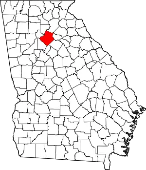 Map of Georgia highlighting Gwinnett County | |
| Towns | ||
| CDP | ||
| Unincorporated communities | ||
| Footnotes | ‡This populated place also has portions in an adjacent county or counties | |
| ||
Municipalities and communities of Walton County, Georgia, United States | ||
|---|---|---|
| Cities |  Map of Georgia highlighting Walton County | |
| Towns | ||
| Unincorporated communities | ||
| Footnotes | ‡This populated place also has portions in an adjacent county or counties | |
| ||
| Authority control |
|---|