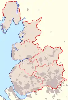
Lonsdale Hundred
The Lonsdale Hundred is an historic hundred of Lancashire, England.[2] Although named after the dale or valley of the River Lune, which runs through the city of Lancaster, for centuries it covered most of the northwestern part of Lancashire around Morecambe Bay, including the detached part around Furness. Ironically, only the detached part of North Lonsdale still remains partly within a British parliamentary constituency under the name of Lonsdale. It is part of the Westmorland and Lonsdale constituency.
| Hundred of Lonsdale | |
|---|---|
| Lancashire Hundred | |
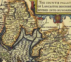 Lonsdale Hundred depicted in John Speed's 1610 map of Lancashire | |
| Area | |
| • 1831 | 1,237,970 acres (5,009.9 km2) |
| History | |
| • Created | Before 1168 |
| • Abolished | Mid-19th Century, however never formally abolished |
| • Succeeded by | North Lonsdale Rural District, Lancaster Rural District |
| Status | Ancient Hundred |
| • HQ | Lancaster |
| Subdivisions | |
| • Type | Parish(es) |
| • Units | South of the Sands Lancaster (part) • Cockerham (part) • Heysham; Halton • Bolton-Le-Sands • Warton • Burton (part) • Melling • Claughton • Tatham • Tunstall • Whittington • Thornton (part) North of the Sands Cartmel Furness • Dalton • Aldingham • Urswick • Pennington • Ulverston • Hawkshead • Colton • Kirkby Ireleth[1] |
Lonsdale was not recorded as a hundred in the Domesday Book, but the name does appear, in the returns for Yorkshire, apparently as a manor attached to Cockerham. 'in Lonsdale' has been appended to a number of places within the Lune's watershed. Kirkby Lonsdale, Burton-in-Lonsdale, Thornton-in-Lonsdale retain the name but Middleton, Sedbergh, Ingleton and Newby, near Clapham have previously been recorded with it. Following the creation of the hundred sometime during the late 11th or early 12th centuries, parts of the district were included in Westmorland and others in Craven within the West Riding of Yorkshire.[3] The hundred had been defined by 1168 and the bailiwick was granted to Adam de Kellet (of Nether Kellet) in 1199.[4]
Other places in the Lonsdale hundred included Lancaster, Bolton-le-Sands, Barrow-in-Furness, Dalton-in-Furness, Ulverston, and Morecambe. The Furness Peninsula was known as Lonsdale North of the Sands, the major part of which later constituted (from 1894 to 1974) the North Lonsdale Rural District.
In 1831, the population of males over twenty years old was given as 10,707,[5] meaning the total population would likely be over 20,000 during that year.
References
- http://www.british-history.ac.uk/vch/lancs/vol8/pp1-3
- A Vision of Britain through Time. "A vision of Lonsdale Hundred". Retrieved 2007-06-13.
- Farrer & Brownbill 1914, p. 1
- Farrer & Brownbill 1914, p. 2
- A Vision of Britain through Time. "Lonsdale Hundred: Total number of males aged 20 and over". Retrieved 2007-06-13.
- Farrer, William; Brownbill, John, eds. (1914), The Victoria History of the County of Lancaster Vol 8, Victoria County History - Constable & Co, OCLC 270761426