Loudervielle
Loudervielle is a commune in the Hautes-Pyrénées department in south-western France.
Loudervielle | |
|---|---|
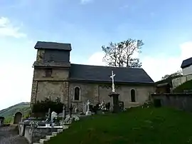 The church of Sainte-Marie-Madeleine | |
.svg.png.webp) Coat of arms | |
Location of Loudervielle 
| |
 Loudervielle  Loudervielle | |
| Coordinates: 42°48′35″N 0°25′19″E | |
| Country | France |
| Region | Occitanie |
| Department | Hautes-Pyrénées |
| Arrondissement | Bagnères-de-Bigorre |
| Canton | Neste, Aure et Louron |
| Government | |
| • Mayor (2020–2026) | Évelyne Bertranuc |
| Area 1 | 5.39 km2 (2.08 sq mi) |
| Population (2017-01-01)[1] | 54 |
| • Density | 10/km2 (26/sq mi) |
| Time zone | UTC+01:00 (CET) |
| • Summer (DST) | UTC+02:00 (CEST) |
| INSEE/Postal code | 65283 /65510 |
| Elevation | 1,038–2,034 m (3,406–6,673 ft) (avg. 1,150 m or 3,770 ft) |
| 1 French Land Register data, which excludes lakes, ponds, glaciers > 1 km2 (0.386 sq mi or 247 acres) and river estuaries. | |
Loudervielle sits in the Bigorre region, in the valley of the river Louron. The west side of the mountain pass Col de Peyresourde lies on the eastern edge of the commune.
The village's original Latin name, found in the church register of Comminges, was De Lodirvilla, and the name in Occitan is Lodervièla.[2]
Coat of arms of Loudervielle
The village arms are described as azure, a lion or, a chief argent with three crescents of the field, the largest in the middle.
Sights and monuments
- Church of Sainte-Marie-Madeleine
- 12th-century Tour de Moulor, the ruins of a medieval castle.
References
- "Populations légales 2017". INSEE. Retrieved 6 January 2020.
- Michel Grosclaude et Jean-François Le Nail, Dictionnaire toponymique des communes des Hautes-Pyrénées intégrant les travaux de Jacques Boisgontier, Conseil général des Hautes-Pyrénées, 2000.
| Wikimedia Commons has media related to Loudervielle. |
| Authority control |
|---|
This article is issued from Wikipedia. The text is licensed under Creative Commons - Attribution - Sharealike. Additional terms may apply for the media files.