Sarniguet
Sarniguet is a commune in the Hautes-Pyrénées department in southwestern France.
Sarniguet | |
|---|---|
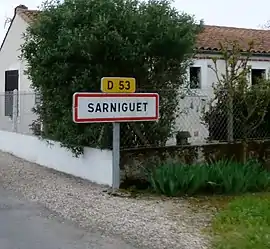 The road into Sarniguet | |
.svg.png.webp) Coat of arms | |
Location of Sarniguet 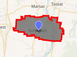
| |
 Sarniguet  Sarniguet | |
| Coordinates: 43°19′07″N 0°05′19″E | |
| Country | France |
| Region | Occitanie |
| Department | Hautes-Pyrénées |
| Arrondissement | Tarbes |
| Canton | Vic-en-Bigorre |
| Area 1 | 2.07 km2 (0.80 sq mi) |
| Population (2017-01-01)[1] | 255 |
| • Density | 120/km2 (320/sq mi) |
| Time zone | UTC+01:00 (CET) |
| • Summer (DST) | UTC+02:00 (CEST) |
| INSEE/Postal code | 65406 /65390 |
| Elevation | 248–257 m (814–843 ft) (avg. 252 m or 827 ft) |
| 1 French Land Register data, which excludes lakes, ponds, glaciers > 1 km2 (0.386 sq mi or 247 acres) and river estuaries. | |
Geography
Sarniguet is located on the left bank of the Adour River, which flows at highly variable rates through the vast and fertile plain of the same name. The commune of Sarniguet is 207 hectares (510 acres) in area and 11 km (6.8 mi) distant from the department capital, Tarbes. The patchwork terrain of Sarniguet consists heavily of plains surrounded by forested borders of alder and Italian poplar.
References
- "Populations légales 2017". INSEE. Retrieved 6 January 2020.
| Wikimedia Commons has media related to Sarniguet. |
| Authority control |
|---|
This article is issued from Wikipedia. The text is licensed under Creative Commons - Attribution - Sharealike. Additional terms may apply for the media files.