Lough Scur
Lough Scur (Irish: Loch an Scoir, meaning "the lake of the horses, pasturage, troop"[n 1]) is a freshwater lake in south County Leitrim, northwest Ireland. It is part of the Shannon–Erne Waterway. There have been Human settlements here since the New Stone Age. Modern features include quays and moorings. Protected features are Castle John, three Crannogs, and the causeway into Rusheen Island, though "Jail Island" is not protected. The ecology of Lough Scur, and indeed all county Leitrim lakes, is threatened by pollution and invasive species such as curly waterweed, zebra mussel, and freshwater clam.
| Lough Scur | |
|---|---|
 Location in Ireland | |
| Location | County Leitrim |
| Coordinates | 54°1′31″N 7°57′21″W |
| Lake type | Freshwater |
| Native name | Loch an Scoir (Irish) |
| Primary inflows | Aghacashlaun River, Shannon–Erne Waterway |
| Primary outflows | Shannon–Erne Waterway |
| Catchment area | 62.87 km2 (24.3 sq mi) |
| Basin countries | Ireland |
| Surface area | 1.14 km2 (0.44 sq mi) |
| Max. depth | 5 m (16 ft) |
| Surface elevation | 62 m (203 ft) |
| Islands | 2 |
| References | [1][2] |
Etymology
Fanciful folklore of the 19th century claimed Lough Scur was named from Oscar son of Oisín, and his grave lay at Aghascur, "the field of the Scur".[3] However, it is pointed out the word "Scur" (Irish: Scor, genitive scuir) has various meanings, and probably translates to "lake of the horse-stud". O’Donovan suggests 'Scuir' means "lake of the camp", and the placenames database of Ireland suggests Lough Scuir means "the lake of the horses, pasturage, troop".[3]
Geography
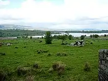
Lough Scur is about 1 kilometre (0.6 mi) northwest of Keshcarrigan. It covers an area of 1.14 square kilometres (0.4 sq mi).[2] Lough Scur is deep with generally a soft mud or compact peat bottom, the shallowest portion is the northern reach, between Driny and Drumcong, probably due to the large quantity of detritus carried into it by a mountain stream at Kiltubrid townland. Beyond the roscarbon shoal there is an isolated rock almost level with the summer water surface, nearly circular, measuring c. 10 – c. 15ft across. Lough Marrave might be considered a continuation of Lough Scur, as they share the same level and connected by a half-mile channel.[4] Keshcarrigan lough is connected to Lough scur by a small stream about 250 metres (820.2 ft) in length. Carrickaport Lough drains into Lough Scur by a 450 metres (1,476.4 ft) stream running through Drumcong townland.[5] Drumaleague Lough, lying 1 kilometre (0.6 mi) to the south west, is connected via the Shannon–Erne Waterway. Sub-glacial Rogen moraine landforms are evident in the valley between Slieve Anierin and Lough Scur, caused by ice age glaciers moving northeast to southwest over millions of years, the Morainic drift heaping up thousands of drumlins in the surrounding lowlands.[6][7]
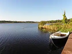 Lough Scur, Corglass. Looking west
.jpg.webp) Train at Lough Scur & Drumcong, Mar 14 1959
Train at Lough Scur & Drumcong, Mar 14 1959 Lough Scur, Corglass. Looking south
Ecology
Fish present in Lough Scur include "roach-bream hybrids" (54%), Roach (22%), Perch (9%), Bream (9%, including. Skimmers), Pike (6%), nine-spine stickleback, and Eel.[8][9] The large proportion of hybrids results from the Pike here preferring Roach (86%), Stickleback (9%), and Perch (4%) in their overall diet.[10] The pike population is the "native Irish strain" (Irish: liús meaning 'Irish Pike') not the other European Pike strain (Irish: gailliasc meaning 'strange or foreign fish').[11] Large pike have been caught here weighing 10 kg (22 lb) or more.[12] When surveyed in 2002, no zebra mussels were reported at the highest water level,[13][n 2] and in 2005 the water quality was rated as mesotrophic.[14][n 3]
Demography
Canal
Lough Scur forms part of the Shannon–Erne Waterway, lying at the summit of the canal connecting Lough Scur to the River Shannon, just south of Leitrim village. The original canal was constructed in the 1840s, fell into decline as the rail network prospered, but was reopened in 1994 to develop the region's tourism industry.[16] The levels of Lough Scur are controlled by Waterways Ireland via two Spillways. The recording of large numbers of ancient dug-out canoes from county Leitrim remind us that waterways have always been a key means of transport in Ireland.[17]
Villages
The primary human settlements at Lough Scur are the villages of Keshcarrigan and Drumcong.
Historical heritage
Stone Age
Mesolithic hunter-gatherers may have frequented Lough Scur sometime c. 8,000 – c. 4000BC.[18][n 4] Archaeological finds from Lough Scur include five Lithic flakes, a polished shale axe, a dolerite axe roughout, and a piece of leather under a dugout canoe.[18][n 5] The leather and canoe are not dated, but the flakes are probably Mesolithic.[18]
Raftery (1957) claimed small Stone Age crannogs were observed at Lough Scur. The pre-Bronze Age material were described as flat, circular sites of stones, 6-10m in diameter and 400 cm above the lake mud. The interiors often consisted of brushwood, irregularly sized stones and sometimes horizontal timbers, some charred. Charred animal bones were found on the surface,[19] indicating swine (wild boar, domestic pig) and oxen were part of the diet.[20]
Bronze Age
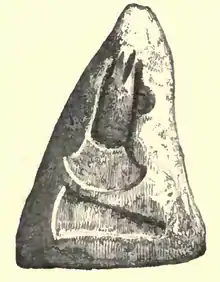
There was a Bronze Age human settlement at Lough-Scur c. 4,000 – c. 2,500BC. The "Lough-Scur Stone Mould" is an triangular coarse block of white sandstone found on the Lough-Scur crannog,[21] bearing matrices for casting Copper and Bronze flat axes or spear-heads,[22][23] and containing three moulds, one flat axe and one looped Palstave on obverse, with one flat axe on reverse.[24][25] These were fashioned before the lake dwellers became familiar with the use of Iron sourced from Sliabh an Iarainn for example.[26] The illustration shows the side with moulds for a plain Celt (tool) 7.5cm long and for a Celt 10cm long with cross strop and ring.[27] The mould is part of the Royal Irish Academy's Collection.
Iron Age
Lough Scur contains five or six crannogs (artificial lake dwellings).[28][29] Pre-Celtic archaeological remains from Lough Scur are preserved by the Royal Irish Academy museum and National Museum of Ireland-
- Five Lithic flakes, shale axe, dolerite axe roughout, piece of leather.[n 6]
- The Lough-Scur Stone Mould.[27][31]
- The Lough-Scur Quern-stone, perhaps the largest example in Ireland, discovered on the crannog.[31][32]
- The Kiltubrid Shield discovered on Kiltubrid townland nearby Lough Scur.
- The Keshcarrigan Bowl discovered in the canal between Lough Scur and Lough Marrave.[33]
- Approximately one cask of bones found on Lough Scur crannog.[31]
Aghascur Druid's Altar
An ancient stone monument, probably a Druids Altar,[34] is prominently located 400 yards south of the lake in a sloping pasture anciently named Irish: Aghascur, meaning "field of the Scur".[3] Set against the spectacular backdrop of Lough Scur and Slieve Anierin, it is marked "Dermot and Grania's Bed" on some maps.[35] Although two erect stones at the south have certainly been artificially set upright, this anomalous monument is extremely doubtful and, on the evidence, cannot be accepted as a megalithic tomb, but rather an attempt to split a rock outcrop from underlying bedrock.[36][n 7] It may have been a Druids altar before Christianity. There is also a Cist located here.
Castle O'Connor
In 1265AD, Aedh mac Felim Ó Conchobair constructed a fortified "castle" at Loch Scur.[37][n 7] Defending the Conmhaícne of Muintir Eolais from Norman conquest was a military objective, and in 1270AD his Lough Scur regiment and Conmhaicne forces both participated in the decisive Battle of Áth an Chip.
Castle of Lough Scur
Crannogs occurred at Lough Scur through the Middle Ages,[25] and the Irish Annals allude to a fortified crannog at Lough Scur.
- "1346: Four sons of Cathal, son of Mag Raghnaill the Blind-eye, were taken prisoners on Loch-in-sguir by Concobur Mag Raghnaill. And Tomaltach Mag Raghnaill took them with him to Caisel-Coscraigh and they were killed there, the saddest tale that was done in that time.[38]
- "1390: Manus O'Rourke, who had been imprisoned by O'Reilly in the castle of Lough Oughter, made his escape from it, and went to the castle of Lough-an Scuir; but the Clann-Murtough, being informed of this by his betrayers, they slew him as he was coming ashore out of a cot.[39]
In the 19th century, a portion of a heavy oak-frame, with mortices and cheeks cut into it, was found on a crannog here.[31][40]
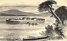
Castle Sean
In 1570 Sean Reynolds built a 'Castle' at Gowly townland on a peninsula called Castle Island.[41][n 8] Castle John was three stories high and surrounded by good rock land. Between c. 1570 – c. 1729 Castle Sean was residence to Sean Reynolds (d. 1619), Humphrey his son (d. 1661), Sean his grandson (captured and probably executed during the Irish Rebellion of 1641) and another grandson James (d. 1729), [n 9] who probably abandoned the Castle during his lifetime. Dilapidated ruins of Castle Sean (Irish: Caisleán Seóin) remain today, but are not preserved as national monument, tourist, or heritage site.[43] Some of the building collapsed c. 1908 but was repaired by a heritage preservation society.[44]
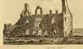 Castle Sean c. 1791
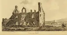 Castle & Jail view
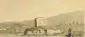 Jail Island c. 1791
Prison Island
On 6 April 1605, Sean and his son Humphrey were appointed gaoler of county Leitrim. They constructed a 'prison' on 'Jail island' (Irish: Oileán an phriosuiin) in Lough Scur. The jail cells were small with holes about six inches in diameter for air.[44] Tradition recalls many people being hanged on the island,[45] and that Sean was killed by a soldier from Longford avenging his sister's death there.[45][46] Prison Island was abandoned once Carrick-on-Shannon gaol became established. Dilapidated ruins of the prison remain but are not preserved for heritage.
Metalworking tradition
A tradition of metalworking at Lough Scur is recorded. Five Metalsmiths from "Lougheskure" obtained grants of pardons in the Elizabethan Fiants c. 1583 – c. 1586AD.[47]
- Gilla Gruma O'Flynn.
- Charles O'Flynn.
- Toole O'Fenane.
- Teige oge O'Fonan and Eoin O'Finan, named as Tinker metal workers.
Book of Lough Scur
In the early 20th century, a book or manuscript titled the “Book of Lough Scur", on the Reynolds family, supposedly existed in the library of an unidentified deceased person living near Keshcarrigan, co. Leitrim.[48]
"Book of LoughScur - A book or manuscript bearing this title, on the Reynolds family (ancient name MacRannal or Magrannal), co. Leitrim, was heard of about three years ago in the neighbourhood of Keshcarrigan, co. Leitrim, as having been seen in the library of a gentleman who had died a little while previously; but his name was not ascertained. Materials are being collected for a history of the Reynolds family, and information regarding this book or the loan of it would be much appreciated. [June 1st 1905]
".
[text: [49] query from [Henry F. Reynolds, 93, Denbigh Street, S.W.]
"I have never heard of the 'Book of Lough- scur,' but if it be in existence, it will probably be found either in Trinity College or the Royal Irish Academy, Dublin. [Oct 21, 1905]
".
[text: [48] response from [Baron Seton of Andria]
See also
- List of loughs in Ireland
- The Keshcarrigan Bowl
- Kiltubrid Shield
References and notes
Notes
- Scuir with an implied meaning of "troop" or "camp" might recall the garrison of Aodh O'Connor, whose castle stood here.
- White-clawed crayfish are typically not present where a zebra mussel infestation is found to exist; Carrickaport Lough nearby at Drumcong has zebra mussel infestation.
- Trophic states of "Oligotrophic" and "Mesotrophic" are desirable, but freshwater lakes rated 'Eutrophic' or 'Hypertrophic' indicates pollution.[15]
- The Mesolithic period began about 11,660 years BP ending with the introduction of farming.
- The term "roughout" means a work produced in rough or preliminary form.
- The Lough Scur canoe was probably destroyed. Wilde (1861) complained of the poor preservation of dugout boat discoveries, noting many had been broken up for firewood since their recovery.[30]
- Aghascur ('field of the camp' according to O'Donovan) is marked as Lough Scur ('lake of the camp') on modern maps. It is possible O'Connor of Connacht maintained his regiment at Aghascur ('field of the camp') c. 1265AD to defend the Conmaicne of south Leitrim from Norman conquest.
- The suggestion by Grose Castle Sean was erected by O’Rourke,[42] is unfounded.
- James's son, George Nugent Reynolds Senior, who probably never lived at Castle Sean, was shot and killed by Robert Keon on the morning of October 16, 1786. Keon was tried and executed in 1788 for murder.
Citations
- Joyce 1883, pp. 126.
- Haug 2007, pp. 54.
- Loch an Scoir, pp. Archival records.
- MacMahon 1845, pp. 22.
- MacMahon 1845, pp. 23.
- Moody 1976, pp. 48.
- McCabe 2008, pp. 65.
- Inland Fisheries Ireland 2014, pp. 20-25.
- discoverireland.ie 2017.
- Inland Fisheries Ireland 2014, pp. 15.
- Pedreschi, Kelly-Quinn, Caffrey, O’Grady, Mariani, Phillimore 2014.
- anglingireland.
- Minchin, Lucy, Sullivan 2002, pp. 10.
- Clenaghan, Clinton, Crowe 2005, pp. 97.
- Clenaghan, Clinton, Crowe 2005, pp. 8.
- iRBD 2008, pp. 56.
- O’Drisceoil, Leenane, Davis, Fitzgibbon, Teehan 2014, p. 3.
- Driscoll 2006, pp. 229.
- Fredengren 2013, pp. 130.
- Wilde 1854, pp. 332.
- Fredengren 2013, pp. 194.
- Munro 1890, pp. 370.
- Coffey 1913, pp. 9.
- Callander 1904, pp. 492.
- British Museum 1904, pp. 143.
- Dalton 1923, pp. 63.
- Wood-Martin 1886, pp. 72.
- Leitrim Observer 1970, pp. 3.
- Mulvany, Fraser, Roberts, Mulvany, O'Flaherty 1852, pp. xliii.
- O'Sullivan 2004, pp. 345.
- Mulvany, Fraser, Roberts, Mulvany, O'Flaherty 1852, pp. lx.
- Wood-Martin 1886, pp. 242.
- Mulvany, Fraser, Roberts, Mulvany, O'Flaherty 1852, pp. lix.
- De Valera, O'Nuallain 1972, pp. xvii.
- DeValera, O'Nuallain 1972, pp. 84.
- DeValera, O'Nuallain 1972, pp. 85.
- Hazard 2012, pp. 1.
- Bambury, Beechinor 2003, pp. U1343.3.
- AFM, pp. M1390.4.
- Munro 1890, pp. 365.
- Meehan 1906, pp. 144.
- Grose 1795, pp. 91.
- National Monuments Service 2009, pp. 1.
- Whelan 1938, pp. 385.
- Rowley 1937, pp. 268.
- An Clochar, Cara Droma Ruisc 1938, pp. 321.
- Rondelez 2014, p. 580.
- White 1907, pp. 429.
- Notes and Queries, Oxford Journals (Firm), page 334. https://books.google.com/books?id=S92ddIdH3UIC&pg=PA334
Sources
- Joyce, Patrick Weston (1883). The Geography of the Counties of Ireland. p. 127. Retrieved 5 Aug 2015.CS1 maint: ref=harv (link)
- anglingireland. "Lough Scur". Inland Fisheries Ireland. Retrieved 5 Aug 2015.CS1 maint: ref=harv (link)
- "Loch an Scoir". pp. Archival records.CS1 maint: ref=harv (link)
- Meehan, Joseph (1906). "Notes on the Mac Rannals of Leitrim and their Country". Journal of the Royal Society of Antiquaries of Ireland: 144–145. Retrieved 5 Aug 2015.CS1 maint: ref=harv (link)
- Golden, Anne (2007). The Shannon-Erne Navigation Architectural,Engineering and Industrial Heritage 2007 (PDF) (Report). Commissioned by Waterways Ireland and carried out by Headland Archaeology Ltd.CS1 maint: ref=harv (link)
- O'Laughlin, Michael C. (2002). Contributor: Irish Genealogical Foundation (US) (ed.). The Book of Irish Families, Great & Small. Volume 1 of Families of Ireland Series (illustrated, digital ed.). Irish Roots Cafe. ISBN 978-0940134096.CS1 maint: ref=harv (link)
- Inland Fisheries Ireland (2014). The Diet of Pike in Irish Watercourses (Report) (Layman's Report, Trophic flexibility and diet of pike (Esox lucius L.) in Ireland ed.).CS1 maint: ref=harv (link)
- National Monuments Service (2009). Leitrim (PDF) (Report). National Monuments in State Care: Ownership & Guardianship. Environment, Heritage and Local Government.CS1 maint: ref=harv (link)
- iRBD (2008). Environmental Report, North Western iRBD (PDF) (Report). Strategic Environmental Assessment for the Water Framework Directive River Basin Management Plans and Programmes of Measures. North Western International river basin district (INTERREG).CS1 maint: ref=harv (link)
- Pedreschi, D.; Kelly-Quinn, M.; Caffrey, J; O'Grady, M.; Mariani, S.; Phillimore, A. (2014), "Genetic structure of pike (Esox lucius) reveals a complex and previously unrecognized colonization history of Ireland", Journal of Biogeography, Journal of Biogeography, 41(3), 548–560., 41 (3): 548–560, doi:10.1111/jbi.12220, PMC 4238397, PMID 25435649CS1 maint: ref=harv (link)
- Haug, Per Ivar (2011). "Gazetteer of Ireland". Til Opplysning, A series of papers from the University Library in Trondheim, Nummer 16 (Second ed.). Hommelvik: UBiT, Universitetsbiblioteket i Trondheim. Cite journal requires
|journal=(help)CS1 maint: ref=harv (link) - discoverireland.ie (2017). "Coarse Angling Keshcarrigan".CS1 maint: ref=harv (link)
- Clenaghan, Conor; Clinton, Frank; Crowe, Matthew (2005). Phosphorus Regulations National Implementation Report (PDF) (Report). Environmental Protection Agency, Office of Environmental Enforcement.CS1 maint: ref=harv (link)
- Minchin; Lucy; Sullivan (2002). Monitoring of zebra mussels in the Shannon-Boyle navigation, other navigable regions and principal Irish lakes, 2000 & 2001.* (PDF) (Report). Marine Environment and Health Series, No. 5, 2002. Marine Institute.CS1 maint: ref=harv (link)
- Joyce, P. W. (Patrick Weston) (1913). Irish names of places (PDF). v.3. Dublin : Phoenix.CS1 maint: ref=harv (link)
- Rodelez, Paul (2014). Ironworking in late medieval Ireland, c. AD. 1200 to 1600 (Thesis). hdl:10468/1944.CS1 maint: ref=harv (link)
- MacMahon, John (1845). Correspondance relative to the navigation between Lough Erne and the River Shannon (Report). Parliamentary Papers, House of Commons and Command, Volume 45 (Digitized 2006 from original in Harvard University ed.). H.M. Stationery Office.CS1 maint: ref=harv (link)
- Munro, Robert (1890). The lake-dwellings of Europe: being the Rhind lectures in archaeology for 1888 (PDF). London [etc.]: Cassell & company, limited.CS1 maint: ref=harv (link)
- White, William (1907). Notes and Queries. Tenth series, Vol. VII (Number 158 ed.). Oxford University Press.CS1 maint: ref=harv (link)
- Grose, Francis (1795). The antiquities of Ireland (PDF). Vol. 2. Printed for S. Hooper.CS1 maint: ref=harv (link)
- O’Sullivan, Aidan (2004). The social and Ideological role of Crannogs in Early Medieval Ireland (PDF) (Thesis) (PhD. Thesis ed.). Department of Modern History, National University of Ireland, Manooth.CS1 maint: ref=harv (link)
- Dalton, John P. (1923). "Breifne before the Ui-Bruin" (PDF). The Breifny Antiquarian Society's Journal. Cavan: The Anglo Celt, Ltd. Printing Works. II (I): 57–82.CS1 maint: ref=harv (link)
- Driscoll, Killian (2006). The early prehistory in the west of Ireland: Investigations into the social archaeology of the Mesolithic, west of the Shannon, Ireland (PDF) (Thesis) (M.Litt. Thesis ed.). Department of Archaeology, National University of Ireland, Galway.CS1 maint: ref=harv (link)
- Wood-Martin, W. G. (William Gregory) (1886). The lake dwellings of Ireland: or, Ancient lacustrine habitations of Erin, commonly called crannogs (PDF). Dublin : Hodges, Figgis & co.,; [etc., etc.]CS1 maint: ref=harv (link)
- De Valera, Ruaidhri; O'Nuallain, Sean (1972). Survey of the Megalithic Tombs of Ireland (PDF). Vol. III. Dublin: Published by the Stationery office.CS1 maint: ref=harv (link)
- Callander, J. Graham (1904). "Stone mould for casting flat bronze axes" (PDF). Proceedings of the Society: 487–505. Cite journal requires
|journal=(help)CS1 maint: ref=harv (link) - Fredengren, Christina (2013). Crannogs (PDF) (Report). Stockholm University.CS1 maint: ref=harv (link)
- British Museum (1904). A guide to the antiquities of the Bronze Age (PDF). Dept. of British and Mediaeval Antiquities: [Oxford] Trustees of the B.M.CS1 maint: ref=harv (link)
- Coffey, George (1913). The Bronze Age in Ireland (PDF). Dublin, Hodges, Figgis, & co., limited; [etc., etc. ].CS1 maint: ref=harv (link)
- McCabe, A. Marshall (2008). Glacial Geology and Geomorphology: The Landscapes of Ireland (illustrated ed.). Dunedin. ISBN 978-1903765876.CS1 maint: ref=harv (link)
- Wilde, William (March 1854). "The food of the Irish, part II". Dublin University Magazine: A Literary and Philosophic Review. Vol. 43 no. 255. Curry. pp. 317–333.CS1 maint: ref=harv (link)
- Mulvany, W. T.; Fraser, William; Roberts, Samuel; Mulvany, Thomas J.; O'Flaherty, John (1852). Appendix No. V: Notices of Antiquities Presented to the Royal Irish Academy by W. T. Mulvany, Esq., M. R. I. A., on the Part of the Commissioners of Public Works. Proceedings of the Royal Irish Academy (Report). 5 (1850 - 1853). Royal Irish Academy. pp. xxxi–lxvi. JSTOR 20489812.CS1 maint: ref=harv (link)
- O'Drisceoil, C; Leenane, M; Davis, S; Fitzgibbon, B; Teehan, M (2014). THE BLACK PIG'S DYKE REGIONAL PROJECT REPORT (PDF) (Report). 1 of 2. Archived from the original (PDF) on 2017-02-18. Retrieved 2017-02-18.CS1 maint: ref=harv (link)
- Moody, Theodore William (1976). Theodore William Moody; Francis X. Martin; Francis John Byrne; Art Cosgrove (eds.). A New History of Ireland: Prehistoric and early Ireland. Volume 1 of A New History of Ireland: Prehistoric and Early Ireland, Ed. by Daibhi O Croinin, W. E. Vaughan (illustrated, reprint ed.). Oxford University Press. ISBN 978-0198217374.CS1 maint: ref=harv (link)
- Rowley, Thomas (1937). "Legend of Lough Scurr" (Online ed.). Drumrane, Co. Leitrim: Duchas. pp. 268–269.CS1 maint: ref=harv (link)
- Whelan, Thomas (1938). "Local ruins" (Online ed.). Rossy, Co. Leitrim: Duchas. pp. 384–5.CS1 maint: ref=harv (link)
- An Clochar, Cara Droma Ruisc (1938). "Lough Scur" (Online ed.). Carrick-on-Shannon, Co. Leitrim: Duchas. p. 312.CS1 maint: ref=harv (link)
- Leitrim Observer (1970). "Drumcong jamboree and dancing carnival". Leitrim Observer. Archived from the original on 2017-02-02.CS1 maint: ref=harv (link)
- Annals of the Four Masters, ed. & tr. John O'Donovan (1856). Annála Rioghachta Éireann. Annals of the Kingdom of Ireland by the Four Masters... with a Translation and Copious Notes. 7 vols (2nd ed.). Dublin: Royal Irish Academy. CELT editions. Full scans at Internet Archive: Vol. 1; Vol. 2; Vol. 3; Vol. 4; Vol. 5; Vol. 6; Indices.
- Bambury, Pádraig; Beechinor, Stephen (2003). "The Annals of Ulster" (Electronic edition compiled by the CELT Team (2003) ed.). CELT: Corpus of Electronic Texts: a project of University College Cork College Road, Cork, Ireland—http://www.ucc.ie/celt.CS1 maint: ref=harv (link)
- Hazard, Benjamin (2012). "Annales Dominicani de Roscoman, 1163—1314: Introduction". Corpus of Electronic Texts Edition.CS1 maint: ref=harv (link)
External links
- "Gowly Townland, Co. Leitrim".CS1 maint: ref=harv (link)
- "Gabhlaigh/Gowly".CS1 maint: ref=harv (link)
- "Loughscur Megalithic Tomb? - County Leitrim". 2002.CS1 maint: ref=harv (link)
Places in County Leitrim | ||
|---|---|---|
| Towns | 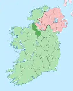 | |
| Villages | ||
| Townlands | ||
| Loughs | ||
| Mountains | ||
| Baronies | ||
| Parishes | ||
| ||