Lubusz Voivodeship
Lubusz Voivodeship, or Lubusz Province[3] (Polish: województwo lubuskie [vɔjɛˈvut͡stfɔ luˈbuskʲɛ], is a voivodeship (province) in western Poland.
Lubusz Voivodeship
Województwo lubuskie | |
|---|---|
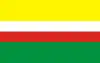 Flag 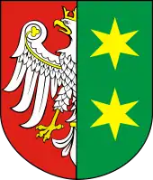 Coat of arms | |
.png.webp) Location within Poland | |
_-_PL.svg.png.webp) Division into counties | |
| Country | |
| Seats |
|
| Counties | |
| Government | |
| • Voivode | Władysław Dajczak (PiS) |
| • Marshal | Elżbieta Polak (PO) |
| Area | |
| • Total | 13,987.93 km2 (5,400.77 sq mi) |
| Population (2019-06-30[1]) | |
| • Total | 1,013,031 |
| • Density | 72/km2 (190/sq mi) |
| • Urban | 657,844 |
| • Rural | 355,187 |
| ISO 3166 code | PL-08 |
| Vehicle registration | F |
| HDI (2017) | 0.829[2] very high · 15th |
| Website | lubuskie.pl |
| |
It was created on January 1, 1999, out of the former Gorzów Wielkopolski and Zielona Góra Voivodeships, pursuant to the Polish local government reforms adopted in 1998. The province's name recalls the historic Lubusz Land[4] (Lebus or Lubus), although parts of the voivodeship belong to the historic regions of Silesia, Greater Poland and Lusatia. Until 1945, it mainly formed the Neumark within the Prussian Province of Brandenburg.
The functions of regional capital are shared between two cities: Gorzów Wielkopolski and Zielona Góra. Gorzów serves as the seat of the centrally appointed voivode or governor, while Zielona Góra is the seat of the elected regional assembly (sejmik) and the executive elected by that assembly, headed by a marshal (marszałek).
The region is mainly flat, with many lakes and woodlands. In the south, around Zielona Góra, grapes are cultivated.
Lubusz Voivodeship borders West Pomeranian Voivodeship to the north, Greater Poland Voivodeship to the east, Lower Silesian Voivodeship to the south, and Germany (Brandenburg and Saxony) to the west.
History

By conquest the first leaders of the Polans, Mieszko I and especially Boleslaw I added a number of surrounding territories to the newly established core Polish state, and Lebus Land or Lubusz in Lusatia came under Polish rule. Part of the historic province was located on the western bank of the Oder River, where the main settlement Lubusz, later known as the German town of Lebus, was located.
In 1226 Lebus Land came under direct jurisdiction of the Holy Roman Empire, and around 1250 it was acquired by the Ascanian margraves of Brandenburg. The Lebus Land stayed with Brandenburg throughout (as Electorate within the Holy Roman Empire until 1806, as Prussian Province of Brandenburg since 1815, with Prussia as part of the new Empire of Germany since 1871 and thereafter as a part of the newly created Weimar Republic.
In 1945, the conquest of eastern Germany by the Soviet Red Army was followed by the redrawing of Poland's borders. The eastern part of the Lubusz (Lebus) region was transferred to Poland and became part of the so-called "Regained" or "Recovered Territories". The German-speaking population which had not fled west of the Oder was subsequently expelled, and replaced by Poles from central and former eastern Poland.
In the administrative reforms of 1998, the original proposals made no provision for a separate Lubusz voivodeship – Gorzów would have been part of West Pomeranian Voivodeship, Zielona Góra would have been in Lower Silesian Voivodeship, and other parts of the region were assigned to Greater Poland Voivodeship. However, as a result of popular protests, these proposals were eventually amended to increase the number of voivodeships to 16, leading to the creation of Lubusz Voivodeship.
In 1998, the government of Jerzy Buzek decided to introduce an administrative reform. The biggest changes were the restoration of counties and a reduction in the number of provinces. According to the authors of the reform, only 12 large voivodships were to remain instead of 49 that existed from 1975. Zielona Góra, along with Krosno, Nowa Sól, Żagań, Gubin and Żary, were planned to be part of Lower Silesia Voivodeship while Gorzów, Międzyrzecz, Świebodzin, Słubice and Sulechów were planned to become part of Greater Poland Voivodeship. This caused enormous resistance, especially in the old voivodeship centers prior to the 1975 reform. Protests broke in Bydgoszcz, Koszalin, Opole, Kielce. Opponents of the reform long opted for a solution to maintain 25 voivodeships, including in Gorzów. Finally, the breakthrough was the Paradyż Agreement, concluded on March 13, 1998 in Paradyż. Following public pressure, a separate, Lubusz Voivodeship was created.[5]
Geography
The Lubusz Voivodeship is a land of forests and lakes; forests cover 48% of the area. The river Oder, flowing through the voivodeship, is one of the few large European rivers retaining broadleaved and riparian forests. Areas with the highest natural values are protected as wildlife reserves, national parks (the Drawieński National Park and the Warta Estuary National Park) and landscape parks. The 19th century Mużakowski Park, located on both sides of the Polish-German border, has entered the UNESCO World Heritage List. The voivodeship abounds in lakes, especially in its central and northern parts; around those lakes numerous bathing resorts, holiday centres and farms offering tourist services have been established.[6]
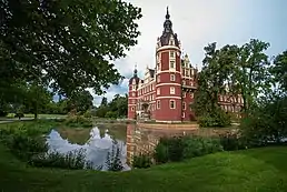
Cities and towns


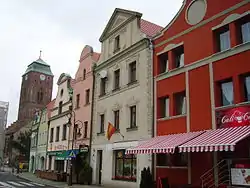
.jpg.webp)
The voivodeship contains 43 cities and towns. These are listed below in descending order of population (as of 2019):[1]
- Zielona Góra (140,874)
- Gorzów Wielkopolski (123,691)
- Nowa Sól (38,763)
- Żary (37,502)
- Żagań (25,731)
- Świebodzin (21,736)
- Międzyrzecz (17,994)
- Kostrzyn nad Odrą (17,778)
- Sulechów (16,831)
- Słubice (16,705)
- Gubin (16,619)
- Lubsko (13,921)
- Wschowa (13,875)
- Szprotawa (11,820)
- Krosno Odrzańskie (11,319)
- Drezdenko (10,122)
- Sulęcin (10,117)
- Strzelce Krajeńskie (9,950)
- Skwierzyna (9,671)
- Kożuchów (9,432)
- Witnica (6,747)
- Rzepin (6,529)
- Nowogród Bobrzański (5,165)
- Zbąszynek (5,020)
- Sława (4,321)
- Jasień (4,309)
- Bytom Odrzański (4,307)
- Czerwieńsk (4,041)
- Ośno Lubuskie (3,951)
- Babimost (3,926)
- Iłowa (3,892)
- Kargowa (3,769)
- Małomice (3,467)
- Dobiegniew (3,061)
- Gozdnica (3,036)
- Nowe Miasteczko (2,756)
- Cybinka (2,749)
- Torzym (2,526)
- Łęknica (2,478)
- Trzciel (2,391)
- Lubniewice (2,059)
- Otyń (1,615)
- Szlichtyngowa (1,278)
Administrative division
Lubusz Voivodeship is divided into 14 counties (powiats): 2 city counties and 12 land counties. These are further divided into 82 gminas.
The counties are listed in the following table (ordering within categories is by decreasing population).
| English and Polish names |
Area (km2) |
Population (2019) |
Seat | Other towns | Total gminas |
| City counties | |||||
| Zielona Góra | 279 | 140,871 | 1 | ||
| Gorzów Wielkopolski | 86 | 123,691 | 1 | ||
| Land counties | |||||
| Żary County powiat żarski |
1,393 | 96,496 | Żary | Lubsko, Jasień, Łęknica | 10 |
| Nowa Sól County powiat nowosolski |
771 | 86,284 | Nowa Sól | Kożuchów, Bytom Odrzański, Nowe Miasteczko | 8 |
| Żagań County powiat żagański |
1,131 | 79,297 | Żagań | Szprotawa, Iłowa, Małomice, Gozdnica | 9 |
| Zielona Góra County powiat zielonogórski |
1,350 | 75,626 | Zielona Góra* | Sulechów, Nowogród Bobrzański, Babimost, Czerwieńsk, Kargowa | 9 |
| Gorzów County powiat gorzowski |
1,213 | 71,669 | Gorzów Wielkopolski* | Kostrzyn nad Odrą, Witnica | 7 |
| Międzyrzecz County powiat międzyrzecki |
1,388 | 57,851 | Międzyrzecz | Skwierzyna, Trzciel | 6 |
| Świebodzin County powiat świebodziński |
937 | 55,753 | Świebodzin | Zbąszynek | 6 |
| Krosno Odrzańskie County powiat krośnieński |
1,390 | 55,018 | Krosno Odrzańskie | Gubin | 7 |
| Strzelce-Drezdenko County powiat strzelecko-drezdenecki |
1,248 | 49,156 | Strzelce Krajeńskie | Drezdenko, Dobiegniew | 5 |
| Słubice County powiat słubicki |
1,000 | 47,018 | Słubice | Rzepin, Ośno Lubuskie, Cybinka | 5 |
| Wschowa County powiat wschowski |
625 | 38,960 | Wschowa | Sława, Szlichtyngowa | 3 |
| Sulęcin County powiat sulęciński |
1,177 | 35,238 | Sulęcin | Torzym, Lubniewice | 5 |
| * seat not part of the county | |||||
Economy
The Gross domestic product (GDP) of the province was 10.8 billion euros in 2018, accounting for 2.2% of Polish economic output. GDP per capita adjusted for purchasing power was 17,600 euros or 58% of the EU27 average in the same year. The GDP per employee was 67% of the EU average.[7]
Protected areas
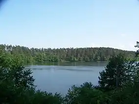
.jpg.webp)
Protected areas in Lubusz Voivodeship include two National Parks and eight Landscape Parks. These are listed below.
- Drawa National Park (partly in Greater Poland and West Pomeranian Voivodeships)
- Ujście Warty National Park
- Ujście Warty Landscape Park (partly in West Pomeranian Voivodeship)
- Barlinek-Gorzów Landscape Park (partly in West Pomeranian Voivodeship)
- Gryżyna Landscape Park
- Krzesin Landscape Park
- Łagów Landscape Park
- Muskau Bend Landscape Park (UNESCO World Heritage Site)
- Przemęt Landscape Park (partly in Greater Poland Voivodeship)
- Pszczew Landscape Park (partly in Greater Poland Voivodeship)
References
- "Population. Size and structure and vital statistics in Poland by territorial divison in 2019. As of 30th June". stat.gov.pl. Statistics Poland. 2019-10-15. Retrieved 2020-03-25.
- "Sub-national HDI - Area Database - Global Data Lab". hdi.globaldatalab.org. Retrieved 2018-09-13.
- Arkadiusz Belczyk,Tłumaczenie polskich nazw geograficznych na język angielski Archived 2016-03-03 at the Wayback Machine [Translation of Polish Geographical Names into English], 2002-2006.
- It is likely that it was a response to the names of some German military units; they have been named after lands that since at least 1945 belong to Poland and the very city of Lubusz is located just outside the Polish border in Germany.
- "Warto było? Oni tworzyli nasze województwo".
- Związek Województw Rzeczypospolitej Polskiej (Union of the Voivodeships of the Republic of Poland) (2010). Polska — Rozwój Regionów.
- "Regional GDP per capita ranged from 30% to 263% of the EU average in 2018". Eurostat.
External links
- Polish Government Link, Lands conquered by Mieszko I and Boleslaw I
- Official website of Lubusz Voivodeship
- - Tourism in Lubuskie - TURYSTYKA
Places adjacent to Lubusz Voivodeship | |
|---|---|
| City counties |
| |
|---|---|---|
| Land counties | ||
| Authority control |
|---|