Lugarno, New South Wales
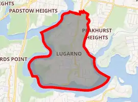
Lugarno is a suburb in southern Sydney, in the state of New South Wales, Australia. The common misconception is that Lugarno is a part of the Sutherland Shire; however, Lugarno is located in the local government area of the Georges River Council, 23 kilometres south of the Sydney central business district and is part of the St George area.
| Lugarno Sydney, New South Wales | |||||||||||||||
|---|---|---|---|---|---|---|---|---|---|---|---|---|---|---|---|
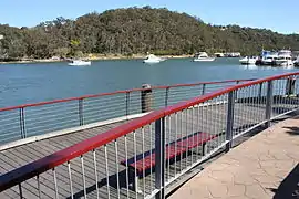 Boardwalk and Lugarno Marina on Georges River | |||||||||||||||
| |||||||||||||||
| Population | 5,606 (2016 census)[1] | ||||||||||||||
| Postcode(s) | 2210 | ||||||||||||||
| Location | 23 km (14 mi) south of Sydney CBD | ||||||||||||||
| LGA(s) | Georges River Council | ||||||||||||||
| State electorate(s) | Oatley | ||||||||||||||
| Federal Division(s) | Banks | ||||||||||||||
| |||||||||||||||
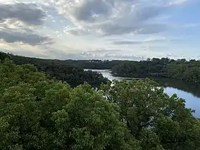
Situated on the northern bank of the Georges River, Lugarno is known for its large areas of bushland. Peakhurst and Peakhurst Heights, to the north, are the only adjacent suburbs. Nearby suburbs include Alfords Point, Illawong (on the other side of the Georges River), Padstow Heights (on the other side of Salt Pan Creek) and Oatley (on the other side of Lime Kiln Bay).
History
Lugarno was named after Lake Lugano, Switzerland by surveyors Major Sir Thomas Livingstone Mitchell (1792-1855) and William Govett (1807-1848) in 1843. An extra 'r' was added for the suburb name. Thomas Lawrence was granted 120 acres (0.49 km2) of land in 1831, on the western side of the peninsula near Salt Pan Creek. Land grants to the east and north were made in 1856 to T.G.Lee with 113 acres (0.46 km2), Frewin Sleath with 45 acres (180,000 m2), John Lushy with 41 acres (170,000 m2) and J.P. Henning with 40 acres (160,000 m2).[2]
The whole area between Arncliffe and Lugarno was originally heavily timbered. Illawarra Road was built by convicts in 1841 and it ran through Gannon’s Forest, down to the Georges River. The road from Arncliffe was later known as Gannon's Forest Road and today is known as Forest Road. The name has been retained in Old Illawarra Road, over the river in Menai and Lucas Heights.
A punt operated from Lugarno across the river from 1843. An established ferry serviced the area from 1887 to 1974, closing with the opening of the Alfords Point Bridge.[3] The suburb was developed into mainly residential in the 1960s when land was released for home sites.
Parks and waterways
- Georges River National Park, CF Williams Reserve, HV Evatt Park, Taylors Reserve
- Georges River, Salt Pan Creek, Soily Bottom Point, Gertrude Point, Edith Bay, Boggywell Creek, Lime Kiln Bay
Churches
St Stephens Anglican Church, Lugarno-Peakhurst Uniting Church and Church of Samoa Parish of Sydney.
Commercial area
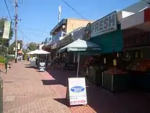
Lugarno has two small sets of shops. At Chivers Hill shops there is a newsagency, IGA supermarket, deli, chemist, a cafe, an Italian restaurant, florist, hairdressers, chicken shop, Chinese take-away, bakery and a dry cleaners. At Lime Kiln shops there is a personal training studio, dental and medical centre, dance studio, real estate agent, and Thai restaurant.
Public transport
Two revenue bus services operate out of Lugarno,[4] both operated by Punchbowl Bus Company. The 943 service runs between Lugarno and Hurstville via Penshurst, while the 942 service operates between Lugarno and Campsie via Riverwood, Roselands, Wiley Park, Lakemba and Belmore.
Sport and recreation
Gannons Park is the home ground of 2 soccer clubs, Lugarno F.C. and Forest Rangers F.C. Evatt Park is the home ground of the St George Junior Baseball Club, Penshurst RSL Rugby League Club, and the Oatley Rugby Union Club. The Lugarno-Peakhurst Uniting Church organises a netball competition which takes place at Olds Park, Penshurst.
Lugarno is home to the Lugarno Football Club, one of the most prominent and respected clubs in the St George Football Association. In the most recent football season the club fielded some 42 teams (20 competition and 22 non-competition teams) and had more than 500 registered players and 102 team officials covering the age groups from the under 6’s to the over 45’s. The Club fields teams across both genders.
Population
At the time of the 2006 census, the population of Lugarno stood at 5,707. 19.1% of census respondents stated they were born overseas with the top countries of birth being United Kingdom 3.1%, China 1.9% and Greece 1.5%. English was stated as the only language spoken at home by 76.0% of residents and the most common other languages spoken were Greek 6.3%, Arabic 2.6% and Cantonese 2.2%. The most common responses for religious affiliation were Catholic 30.2%, Anglican 22.7% and Orthodox 11.9%.[5]
Education
Lugarno is home to only one educational institution, Lugarno Public School.[6]
References
- Australian Bureau of Statistics (27 June 2017). "Lugarno (State Suburb)". 2016 Census QuickStats. Retrieved 19 March 2018.

- The Book of Sydney Suburbs, Compiled by Frances Pollon, Angus & Robertson Publishers, 1990, Published in Australia ISBN 0-207-14495-8, page 158
- National Trust Archived 16 May 2009 at the Wayback Machine
- Punchbowl Bus
- http://www.censusdata.abs.gov.au
- http://www.lugarno-p.schools.nsw.edu.au/
External links
| Wikimedia Commons has media related to Lugarno, New South Wales. |