Georges River Council
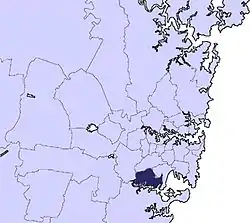
The Georges River Council is a local government area located in the St George region of Sydney located south of the CBD, in New South Wales, Australia. The Council was formed on 12 May 2016 from the merger of the Kogarah City Council and Hurstville City Council.[4]
| Georges River Council New South Wales | |||||||||||||||
|---|---|---|---|---|---|---|---|---|---|---|---|---|---|---|---|
 Location in Metropolitan Sydney | |||||||||||||||
| Coordinates | 33°58′S 151°08′E | ||||||||||||||
| Population |
| ||||||||||||||
| • Density | 3,828.0/km2 (9,914.4/sq mi) | ||||||||||||||
| Established | 12 May 2016 | ||||||||||||||
| Area | 38.36 km2 (14.8 sq mi)[3] | ||||||||||||||
| Mayor | Kevin Greene | ||||||||||||||
| Council seat | Civic Centre, Hurstville | ||||||||||||||
| Region | Metropolitan Sydney | ||||||||||||||
| State electorate(s) | |||||||||||||||
| Federal Division(s) | |||||||||||||||
 | |||||||||||||||
| Website | Georges River Council | ||||||||||||||
| |||||||||||||||
The Council comprises an area of 38.36 square kilometres (14.81 sq mi)[3] and as at the 2016 census had a population of 146,841.[1]
The inaugural mayor of Georges River Council is Kevin Greene, who was elected unopposed by his fellow councillors on 25 September 2017.[5]
Suburbs and localities in the local government area
Suburbs in the Georges River Council area are:[3]
- Allawah
- Beverley Park
- Beverly Hills (parts are located within the City of Canterbury-Bankstown)
- Blakehurst
- Carlton (parts are located within Bayside Council)
- Carss Park
- Connells Point
- Hurstville
- Hurstville Grove
- Kingsgrove (parts are located both within the City of Canterbury-Bankstown and Bayside Council areas)
- Kogarah (parts are located within Bayside Council)
- Kogarah Bay
- Kyle Bay
- Lugarno
- Mortdale
- Mortdale Heights
- Narwee (parts are located within the City of Canterbury-Bankstown)
- Oatley
- Peakhurst
- Peakhurst Heights
- Penshurst
- Ramsgate (parts are located within Bayside Council)
- Riverwood (parts are located within the City of Canterbury-Bankstown)
- Sans Souci (parts are located within Bayside Council)
- South Hurstville
Georges River Council also manages and maintains the following localities:
- Bald Face
- Boggywell Creek
- Carss Point
- Connells Bay
- Edith Bay
- Gertrude Point
- Gungah Bay
- Hurstville Bay
- Jew Fish Bay
- Jew Fish Point
- Harness Cask Point
- Kingsway
- Lime Kiln Bay
- Lime Kiln Head
- Neverfail Bay
- Oatley Bay
- Oatley West
- Shipwright Bay
- Soilybottom Point
- Tom Uglys Point
Demographics
At the 2016 census, there were 146,841 people resident in the Georges River local government area; of these 48.9 per cent were male and 51.1 per cent were female. Aboriginal and Torres Strait Islander people made up 0.5 per cent of the population; significantly below the NSW and Australian averages of 2.9 and 2.8 per cent respectively. The median age of people in Georges River Council was 37 years; marginally lower than the national median of 38 years. Children aged 0 – 14 years made up 16.8 per cent of the population and people aged 65 years and over made up 15.3 per cent of the population. Of people in the area aged 15 years and over, 53.1 per cent were married and 9.1 per cent were either divorced or separated.[1]
At the 2016 census, the proportion of residents in the Georges River local government area who stated their ancestry as Australian or Anglo-Saxon approached 29 per cent of all residents. In excess of 51 per cent of all residents in Georges River Council nominated a religious affiliation with Christianity at the 2016 census, which was below the national average of 57.7 per cent. Meanwhile, as at the census date, compared to the national average, households in the Georges River local government area had a significantly higher than average proportion (56.1 per cent) where two or more languages are spoken (national average was 22.2 per cent); and a lower proportion (42.3 per cent) where English only was spoken at home (national average was 72.7 per cent).[1]
| Selected historical census data for Georges River Council local government area | ||||||
|---|---|---|---|---|---|---|
| Census year | 2016[1] | |||||
| Population | Estimated residents on census night | 146,841 | ||||
| LGA rank in terms of size within New South Wales | 19th | |||||
| % of New South Wales population | 1.96% | |||||
| % of Australian population | 0.63% | |||||
| Cultural and language diversity | ||||||
| Ancestry, top responses | Chinese | 22.8% | ||||
| English | 13.3% | |||||
| Australian | 12.6% | |||||
| Greek | 6.0% | |||||
| Irish | 4.8% | |||||
| Language, top responses (other than English) | Mandarin | 14.4% | ||||
| Cantonese | 9.9% | |||||
| Greek | 5.4% | |||||
| Arabic | 3.6% | |||||
| Nepali | 3.4% | |||||
| Religious affiliation | ||||||
| Religious affiliation, top responses | No religion, as described | 27.4% | ||||
| Catholic | 21.3% | |||||
| Eastern Orthodox | 10.0% | |||||
| Anglican | 8.7% | |||||
| Not stated | 7.5% | |||||
| Median weekly incomes | ||||||
| Personal income | Median weekly personal income | $640 | ||||
| % of Australian median income | 96.68% | |||||
| Family income | Median weekly family income | $1,817 | ||||
| % of Australian median income | 104.79% | |||||
| Household income | Median weekly household income | $1,654 | ||||
| % of Australian median income | 115.02% | |||||
Council

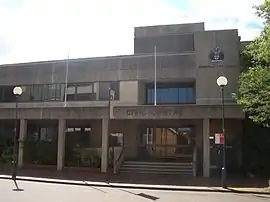
Georges River Council comprises fifteen Councillors elected proportionally, with three Councillors elected in five wards.[6][7] Councillors are elected for a fixed four-year term of office, with the first term to last for three years.[4] The Mayor is elected by Councillors for a period of two years, the Deputy Mayor is elected for one year.[8] The council first met in the Kogarah Civic Centre on 19 May 2016 and the new seat of the council is the Georges River Civic Centre (formerly Hurstville Civic Centre) in MacMahon Street, Hurstville.[9][10]
| Mayor | Term | Notes | |
|---|---|---|---|
| Administrator | John Rayner PSM | 12 May 2016 – 25 September 2017 | Shire Clerk/General Manager of Sutherland Shire 1982–2015[11][12][13] |
| Mayor | Kevin Greene | 25 September 2017 – date | MP for Georges River and Oatley 1999–2011 |
| Deputy Mayor | Kathryn Landsberry | 25 September 2017 – date | [5] |
| General Manager | Term | Notes | |
| Gail Connolly | 12 May 2016 – date | General Manager of Ryde 2015–2016[14][15][7] | |
Current composition
The most recent election was held on 9 September 2017, and the makeup of the Council by order of election, is as follows:

| Party | Councillors | |
|---|---|---|
| Australian Labor Party | 6 | |
| Liberal Party of Australia | 5 | |
| Independents | 3 | |
| Kogarah Residents' Association | 1 | |
| Total | 15 | |
| Ward | Councillor | Party | Notes | |
|---|---|---|---|---|
| Blakehurst Ward[16] | Sam Elmer | Liberal | ||
| Kathryn Landsberry | Labor | Deputy Mayor 2017–date, Kogarah Middle Ward Councillor 2004–2016 | ||
| Sandy Grekas | Independent | |||
| Hurstville Ward[17] | Vince Badalati | Labor | Mayor of Hurstville 2015–2016 | |
| Christina Wu | Liberal | Hurstville Penshurst Ward Councillor 2012–2016 | ||
| Nancy Liu | Independent | Hurstville Hurstville Ward Councillor 2008–2016 | ||
| Kogarah Bay Ward[18] | Nick Katris | Labor | Mayor of Kogarah 2007–2008 | |
| Stephen Agius | Liberal | Mayor of Kogarah 2013–2016 | ||
| Leesha Payor | Kogarah Residents' Association | |||
| Mortdale Ward[19] | Warren Tegg | Labor | ||
| Con Hindi | Liberal | Mayor of Hurstville 2014–2015 | ||
| Lou Konjarski | Independent | |||
| Peakhurst Ward[20] | Kevin Greene | Labor | Mayor 2017–date | |
| Rita Kastanias | Liberal | Hurstville Peakhurst Ward Councillor 2012–2016 | ||
| Colleen Symington | Labor | |||
Council logo
On 3 April 2017, Georges River Council adopted its new logo and branding as required by the NSW state government proclamation. The logo, one of three designed by council staff, was adopted following a community consultation process which looked at the three options. The successful choice, featuring a dragon (which is representative of the St George region and appeared on Hurstville council's logo and coat of arms[21]), was chosen due to "perceived meaning, diversity, relevance to the local area including connections to St George and the logo’s representation to the community including links to multiculturalism and sport".[22]
The consultations resulted in several changes before its unveiling, including changing the direction of the dragon, the adoption of the red colour from the interim council typeface logo used since amalgamation, and the addition of a Port Jackson fig tree leaf motif, to represent the indigenous heritage of the area.[22]
History
Early history
The traditional Aboriginal inhabitants of the land now in the Georges River Council area were thought to be the Cadigal and Biddegal indigenous people.[3]
Local government history
.jpg.webp)
The "Municipal District of Kogarah" was proclaimed on 23 December 1885 and the District’s boundaries commenced at the intersection of the Illawarra Railway Line with the northern shore of George’s River. The Municipal District was re-named the "Municipality of Kogarah" following the passage of the Municipalities Act, 1897 on 6 December 1897.[23] On 22 December 1916 and 1 January 1969, parts of Rockdale Municipality were transferred to Kogarah.[23] In 1993, following the passing of the new Local Government Act, the Municipality of Kogarah became known as "Kogarah Council". Kogarah Council was proclaimed a city in 2008.
In December 1920, Kogarah combined with the councils of Rockdale, Hurstville, and Bexley to form the St George County Council. The elected County Council was established to provide electricity to the Kogarah, Rockdale, Hurstville, and Bexley areas and ceased to exist when it was amalgamated with the Sydney County Council on 1 January 1980.[24][25]
On 25 March 1887 the NSW Government Gazette published a proclamation declaring the "Municipal District of Hurstville". On 28 June 1900, a further proclamation declared Bexley Ward of Hurstville be separated and named the Borough of Bexley.[26] On 28 June 1900 a new proclamation declared the "Municipality of Hurstville". On 2 August 1922, a part of Hurstville was transferred to the Sutherland Shire, on 5 December 1924 part of Canterbury Municipality was transferred to Hurstville, and on 1 January 1931 part of Hurstville was given to Kogarah Municipality. On 25 November 1988 Hurstville was proclaimed a city, becoming the "Hurstville City Council".[26]
Efforts to bring about a unified council for the St George area were raised regularly since 1901 and the 1946 Clancy Royal Commission into local government boundaries recommended the amalgamation of the municipalities of Hurstville, Kogarah, Rockdale and Bexley. In the following act of parliament passed in December 1948, the Local Government (Areas) Act 1948, the recommendations of the commission were modified, leading only to the merger of Bexley and Rockdale councils. A merger was again considered in the 1970s, but 1977 plebiscites run in Hustville and Kogarah rejected the idea. A further idea of amalgamating Kogarah and Hurstville with Sutherland Shire to the south was raised in 1999 but did not progress.[27]
Establishment of Georges River Council
A 2015 review of local government boundaries by the NSW Government Independent Pricing and Regulatory Tribunal recommended that Kogarah merge with Hurstville to form a new council with an area of 38 square kilometres (15 sq mi) and support a population of approximately 147,000.[28] However these proposals met with some opposition, including those in favour of a single "St George Council" combining Hurstville, Kogarah and Rockdale (which was to amalgamate with the City of Botany Bay).[29][30] Despite these concerns however, on 12 May 2016, with the release of the Local Government (Council Amalgamations) Proclamation 2016, the Georges River Council was formed from Hurstville and Kogarah city councils, with former Sutherland Shire General Manager, John Rayner as administrator.[7] The first meeting of the Georges River Council was held at Kogarah Civic Centre on 19 May 2016.
Heritage listings
The Georges River Council has a number of heritage-listed sites, including:
- Beverly Hills, East Hills railway: Beverly Hills railway station[31]
- Blakehurst, 9 Stuart Crescent: Thurlow House[32]
- Carss Park, 74 Carwar Avenue: Carss Cottage[33]
- Oatley, Illawarra railway: Oatley railway station[34]
- Oatley, over Georges River: Old Como railway bridge[35]
- Penshurst, 663-665 King Georges Road: West Maling[36]
- Penshurst, Laycock Road: Penshurst Reservoirs[37]
References
- Australian Bureau of Statistics (27 June 2017). "Georges River (A)". 2016 Census QuickStats. Retrieved 5 July 2017.

- "3218.0 – Regional Population Growth, Australia, 2017-18". Australian Bureau of Statistics. 27 March 2019. Retrieved 27 March 2019. Estimated resident population (ERP) at 30 June 2018.
- "Georges River Council". Community profile. id. 2017. Retrieved 22 July 2017.
- "Georges River Council". Stronger Councils. Government of New South Wales. 12 May 2016. Retrieved 15 May 2016.
- Beichert, Kahlia (25 September 2017). "Georges River Council elects first mayor". St George and Sutherland Shire Leader. Retrieved 26 September 2017.
- "Local government area and ward boundaries". Council elections. Georges River Council. Retrieved 22 July 2017.
- "Local Government (Council Amalgamations) Proclamation 2016 [NSW] - Schedule 6 - Provisions for Georges River Council" (PDF). Parliament of New South Wales. 12 May 2016. p. 18. Retrieved 8 October 2016.
- "Councillor information". Council elections. Georges River Council. Retrieved 22 July 2017.
- Trembath, Murray (17 May 2016). "Administrator John Rayner tells how new Georges River Council will work". St George and Sutherland Shire Leader. Retrieved 25 September 2017.
- Gainsford, Jim (28 January 2017). "Former Kogarah Council chambers up for lease". St George and Sutherland Shire Leader. Retrieved 25 September 2017.
- Gainsford, Jim (14 January 2015). "Sutherland Shire Council general manager John Rayner to retire after 33 years of service". St George and Sutherland Shire Leader. Retrieved 23 September 2017.
- Trembath, Murray (12 May 2016). "Hurstville and Kogarah councils merged - Rockdale still up in the air". St George and Sutherland Shire Leader. Retrieved 23 September 2017.
- "RAYNER, John Wilfred - Public Service Medal". It's an Honour database. Australian Government. 13 June 2016. Retrieved 25 September 2017.
For outstanding public service to local government in New South Wales.
- "Council Praises Former General Manager, Gail Connolly" (Media Release). City of Ryde. 19 May 2016. Retrieved 24 September 2017.
- Bastians, Kate (27 November 2014). "Gail Connolly will become the City of Ryde's first general manager". Northern District Times. Retrieved 24 September 2017.
- "Georges River - Blakehurst Ward". NSW Local Council Elections 2017. NSW Electoral Commission. Retrieved 24 September 2017.
- "Georges River - Hurstville Ward". NSW Local Council Elections 2017. NSW Electoral Commission. Retrieved 24 September 2017.
- "Georges River - Kogarah Bay Ward". NSW Local Council Elections 2017. NSW Electoral Commission. Retrieved 24 September 2017.
- "Georges River - Mortdale Ward". NSW Local Council Elections 2017. NSW Electoral Commission. Retrieved 24 September 2017.
- "Georges River - Peakhurst Ward". NSW Local Council Elections 2017. NSW Electoral Commission. Retrieved 24 September 2017.
- "INSIGNIA - COAT OF ARMS". Library Museum Gallery. Georges River Council. Archived from the original on 16 February 2017. Retrieved 25 September 2017.
- Gainsford, Jim (6 April 2017). "Meet the red dragon - Georges River Council launches new logo". St George and Sutherland Shire Leader. Retrieved 25 September 2017.
- "3802 Kogarah Council". State Records Archives Investigator. State Archives and Records Authority of New South Wales. Retrieved 25 September 2017.
- "3489 St George County Council". State Records Archives Investigator. State Archives and Records Authority of New South Wales. Retrieved 25 September 2017.
- Gainsford, Jim (3 October 2013). "Debate on council mergers revives memories". St George and Sutherland Shire Leader. Retrieved 25 October 2017.
- "2636 Hurstville City Council". State Records Archives Investigator. State Archives and Records Authority of New South Wales. Retrieved 25 September 2017.
- "Council > About Your Council > History of Georges River Council". Georges River Council. Retrieved 25 September 2017.
- "Merger proposal: Hurstville City Council, Kogarah City Council" (PDF). Government of New South Wales. January 2016. p. 7. Retrieved 28 February 2016.
- Galinovic, Maria (3 February 2016). "Kogarah and Hurstville Council amalgamation talks continue". St George and Sutherland Shire Leader. Retrieved 25 September 2017.
- Bliss, Raylene (8 March 2016). "BOTANY BAY, ROCKDALE, KOGARAH AND HURSTVILLE CALL FOR MINISTER TO QUASH AIRPORT COUNCIL MERGER PROPOSAL". Southern Courier. Retrieved 25 September 2017.
- "Beverly Hills Railway Station group". New South Wales State Heritage Register. Office of Environment and Heritage. H01086. Retrieved 18 May 2018.
- "Thurlow House". New South Wales State Heritage Register. Office of Environment and Heritage. H01980. Retrieved 18 May 2018.
- "Carss Cottage". New South Wales State Heritage Register. Office of Environment and Heritage. H00587. Retrieved 18 May 2018.
- "Oatley Railway Station group". New South Wales State Heritage Register. Office of Environment and Heritage. H01214. Retrieved 18 May 2018.
- "Como Rail Bridge". New South Wales State Heritage Register. Office of Environment and Heritage. H01624. Retrieved 18 May 2018.
- "West Maling (Revival Life Centre)". New South Wales State Heritage Register. Office of Environment and Heritage. H00269. Retrieved 18 May 2018.
- "Penshurst Reservoirs". New South Wales State Heritage Register. Office of Environment and Heritage. H01330. Retrieved 18 May 2018.